The viewpoints can all be reached by car and have a parking area or lay-by. The locations are shown on the map below and also given as Ordnance Survey grid references (see Easy Access Beaches).
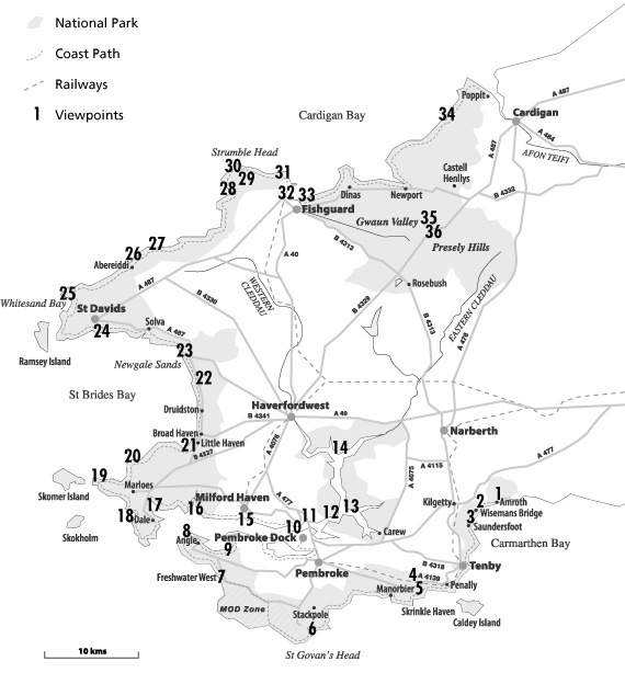
1 Amroth (SN170072 and SN162070)
2 Wiseman’s Bridge (SN146061)
3 Saundersfoot Harbour (SN137048)
4 Manorbier Dak lay-by (SS059976)
5 Manorbier Camp (SN084977)
6 Broad Haven South (SR976938)
7 Freshwater West (SR885998)
8 West Angle Bay (SM854033)
9 Angle Bay, former oil terminal (SM897021)
10 Hobbs Point (SM966042)
11 Cleddau Bridge (SM975047)
12 Burton (SM974053)
13 Lawrenny Quay (SN011061)
14 Picton Ferry (SN010122)
15 Milford Haven (SM009121)
16 Sandy Haven (SM855075)
17 The Gann, Dale (SM808067)
18 West Dale Bay (SM799060)
19 Martin’s Haven car park (SM761089)
20 St Brides (SM801109)
21 Strawberry Hill, Little Haven (SM851123)
22 Maidenhall car park (SM857201)
23 Newgale Sands (SM853211 and SM851216)
24 Caerfai (SM760243)
25 Whitesands Bay (SM734272)
26 Abereiddi (SM796310)
27 Porthgain (SM814326)
28 Pwllderi, seating area (SM894385)
29 Garn Fawr (SM898389)
30 Strumble Head (SM895414)
31 Goodwick, Harbour Heights (SM949391)
32 Goodwick Parrog car park (SM997380)
33 Fishguard Fort (SM962375)
34 Ceibwr (SN106458)
35 Waun Mawn (SN086345)
36 Bwlch Gwynt (SN075322)