array(7) {
["slot_text_override"]=>
string(0) ""
["theme"]=>
string(7) "theme_1"
["microsite_subtitle"]=>
string(39) "Pembrokeshire Coast Path National Trail"
["detail_top"]=>
array(9) {
[""]=>
NULL
["intro_text"]=>
string(71) "Facts and statistics about the Pembrokeshire Coast Path National Trail."
["row_1_text_left"]=>
string(641) "
- Name: Pembrokeshire Coast Path National Trail
- Location: Pembrokeshire, South West Wales
- Length: 186 miles. 299km (Route approved July 1953. Opened 16 May 1970)
- Users: 10% road, 7% MOD road alternative *, 2% high tide road alternative *, 0.3% boat. Off road: 77% footpath, 2.6% bridleway, 0.4% cycle track.
* Careful timing can avoid some road sections
- Number of days to complete: 10 to 15
- Highest Point: Pen yr Afr – 175m
- Lowest Point: Sandy Haven crossing – 2m above low water
- Total rise and fall over entire Trail: approximately 35,000 feet.
"
["row_1_text_right"]=>
string(376) "
Total stiles to cross:
- 540 in 1993
- 400 in 2001
- 298 in 2003
- 181 in 2006
- 108 in 2008
- 25 in 2020.
- Total gates (2018): 475
- Total bridges (2018): 149
- Total signposts (2018): 530
- Total flights of steps (2018): 273
- Total steps (2018): 3779.
"
["row_2_title"]=>
string(10) "Highlights"
["row_2_text"]=>
string(481) "
- Over 50 beaches
- Over 40 Iron Age promontory forts
- Norman/ Medieval castles/ towns (notably Tenby, Manorbier and Pembroke)
- Chain of Napoleonic and later forts
- Scores of lime kilns and other industrial archaeological remains
- Series of picturesque ports (eg Tenby, Solva, Porthgain)
- Innumerable secret coves
- Bosherston Lily Ponds
- Birds and flowers
- Bilingual culture / Landsker Line.
"
["row_2_image"]=>
array(24) {
["ID"]=>
int(6882)
["id"]=>
int(6882)
["title"]=>
string(14) "11. Mill Bay 2"
["filename"]=>
string(18) "11.-Mill-Bay-2.jpg"
["filesize"]=>
int(1462813)
["url"]=>
string(82) "https://www.pembrokeshirecoast.wales/wp-content/uploads/2019/10/11.-Mill-Bay-2.jpg"
["link"]=>
string(109) "https://www.pembrokeshirecoast.wales/things-to-do/walking-in-the-park/web-walks/dale-peninsula/11-mill-bay-2/"
["alt"]=>
string(106) "Plaque commemorating Henry Tudor's landing at Mill Bay, Dale in August 1485 en route to Battle of Bosworth"
["author"]=>
string(2) "48"
["description"]=>
string(106) "Plaque commemorating Henry Tudor's landing at Mill Bay, Dale in August 1485 en route to Battle of Bosworth"
["caption"]=>
string(106) "Plaque commemorating Henry Tudor's landing at Mill Bay, Dale in August 1485 en route to Battle of Bosworth"
["name"]=>
string(13) "11-mill-bay-2"
["status"]=>
string(7) "inherit"
["uploaded_to"]=>
int(6873)
["date"]=>
string(19) "2019-10-15 11:43:59"
["modified"]=>
string(19) "2019-10-15 11:45:03"
["menu_order"]=>
int(0)
["mime_type"]=>
string(10) "image/jpeg"
["type"]=>
string(5) "image"
["subtype"]=>
string(4) "jpeg"
["icon"]=>
string(73) "https://www.pembrokeshirecoast.wales/wp-includes/images/media/default.png"
["width"]=>
int(4000)
["height"]=>
int(3000)
["sizes"]=>
array(69) {
["thumbnail"]=>
string(90) "https://www.pembrokeshirecoast.wales/wp-content/uploads/2019/10/11.-Mill-Bay-2-150x150.jpg"
["thumbnail-width"]=>
int(150)
["thumbnail-height"]=>
int(150)
["medium"]=>
string(90) "https://www.pembrokeshirecoast.wales/wp-content/uploads/2019/10/11.-Mill-Bay-2-300x225.jpg"
["medium-width"]=>
int(300)
["medium-height"]=>
int(225)
["medium_large"]=>
string(90) "https://www.pembrokeshirecoast.wales/wp-content/uploads/2019/10/11.-Mill-Bay-2-768x576.jpg"
["medium_large-width"]=>
int(768)
["medium_large-height"]=>
int(576)
["large"]=>
string(91) "https://www.pembrokeshirecoast.wales/wp-content/uploads/2019/10/11.-Mill-Bay-2-1024x768.jpg"
["large-width"]=>
int(1024)
["large-height"]=>
int(768)
["1536x1536"]=>
string(82) "https://www.pembrokeshirecoast.wales/wp-content/uploads/2019/10/11.-Mill-Bay-2.jpg"
["1536x1536-width"]=>
int(1536)
["1536x1536-height"]=>
int(1152)
["2048x2048"]=>
string(82) "https://www.pembrokeshirecoast.wales/wp-content/uploads/2019/10/11.-Mill-Bay-2.jpg"
["2048x2048-width"]=>
int(2048)
["2048x2048-height"]=>
int(1536)
["featured-small-home"]=>
string(90) "https://www.pembrokeshirecoast.wales/wp-content/uploads/2019/10/11.-Mill-Bay-2-640x422.jpg"
["featured-small-home-width"]=>
int(640)
["featured-small-home-height"]=>
int(422)
["featured-medium-home"]=>
string(91) "https://www.pembrokeshirecoast.wales/wp-content/uploads/2019/10/11.-Mill-Bay-2-1280x844.jpg"
["featured-medium-home-width"]=>
int(1280)
["featured-medium-home-height"]=>
int(844)
["featured-large-home"]=>
string(91) "https://www.pembrokeshirecoast.wales/wp-content/uploads/2019/10/11.-Mill-Bay-2-1440x950.jpg"
["featured-large-home-width"]=>
int(1440)
["featured-large-home-height"]=>
int(950)
["featured-xlarge-home"]=>
string(92) "https://www.pembrokeshirecoast.wales/wp-content/uploads/2019/10/11.-Mill-Bay-2-1600x1086.jpg"
["featured-xlarge-home-width"]=>
int(1600)
["featured-xlarge-home-height"]=>
int(1086)
["featured-small"]=>
string(90) "https://www.pembrokeshirecoast.wales/wp-content/uploads/2019/10/11.-Mill-Bay-2-640x234.jpg"
["featured-small-width"]=>
int(640)
["featured-small-height"]=>
int(234)
["featured-medium"]=>
string(91) "https://www.pembrokeshirecoast.wales/wp-content/uploads/2019/10/11.-Mill-Bay-2-1280x468.jpg"
["featured-medium-width"]=>
int(1280)
["featured-medium-height"]=>
int(468)
["featured-large"]=>
string(91) "https://www.pembrokeshirecoast.wales/wp-content/uploads/2019/10/11.-Mill-Bay-2-1380x505.jpg"
["featured-large-width"]=>
int(1380)
["featured-large-height"]=>
int(505)
["featured-xlarge"]=>
string(91) "https://www.pembrokeshirecoast.wales/wp-content/uploads/2019/10/11.-Mill-Bay-2-1600x703.jpg"
["featured-xlarge-width"]=>
int(1600)
["featured-xlarge-height"]=>
int(703)
["gd-pem-small"]=>
string(90) "https://www.pembrokeshirecoast.wales/wp-content/uploads/2019/10/11.-Mill-Bay-2-640x480.jpg"
["gd-pem-small-width"]=>
int(640)
["gd-pem-small-height"]=>
int(480)
["gd-pem-medium"]=>
string(91) "https://www.pembrokeshirecoast.wales/wp-content/uploads/2019/10/11.-Mill-Bay-2-1024x768.jpg"
["gd-pem-medium-width"]=>
int(1024)
["gd-pem-medium-height"]=>
int(768)
["gd-pem-large"]=>
string(92) "https://www.pembrokeshirecoast.wales/wp-content/uploads/2019/10/11.-Mill-Bay-2-1380x1035.jpg"
["gd-pem-large-width"]=>
int(1380)
["gd-pem-large-height"]=>
int(1035)
["gd-pem-xlarge"]=>
string(92) "https://www.pembrokeshirecoast.wales/wp-content/uploads/2019/10/11.-Mill-Bay-2-1600x1200.jpg"
["gd-pem-xlarge-width"]=>
int(1600)
["gd-pem-xlarge-height"]=>
int(1200)
["profile"]=>
string(90) "https://www.pembrokeshirecoast.wales/wp-content/uploads/2019/10/11.-Mill-Bay-2-600x600.jpg"
["profile-width"]=>
int(600)
["profile-height"]=>
int(600)
["post-thumbnail"]=>
string(90) "https://www.pembrokeshirecoast.wales/wp-content/uploads/2019/10/11.-Mill-Bay-2-125x125.jpg"
["post-thumbnail-width"]=>
int(125)
["post-thumbnail-height"]=>
int(125)
["woocommerce_thumbnail"]=>
string(90) "https://www.pembrokeshirecoast.wales/wp-content/uploads/2019/10/11.-Mill-Bay-2-300x169.jpg"
["woocommerce_thumbnail-width"]=>
int(300)
["woocommerce_thumbnail-height"]=>
int(169)
["woocommerce_single"]=>
string(90) "https://www.pembrokeshirecoast.wales/wp-content/uploads/2019/10/11.-Mill-Bay-2-598x449.jpg"
["woocommerce_single-width"]=>
int(598)
["woocommerce_single-height"]=>
int(449)
["woocommerce_gallery_thumbnail"]=>
string(90) "https://www.pembrokeshirecoast.wales/wp-content/uploads/2019/10/11.-Mill-Bay-2-100x100.jpg"
["woocommerce_gallery_thumbnail-width"]=>
int(100)
["woocommerce_gallery_thumbnail-height"]=>
int(100)
}
}
["row_3_title"]=>
string(19) "Famous Associations"
["row_3_text"]=>
string(2086) "
- Hubba (Norse warrior defeated by King Alfred)
- Gerald Cambrensis
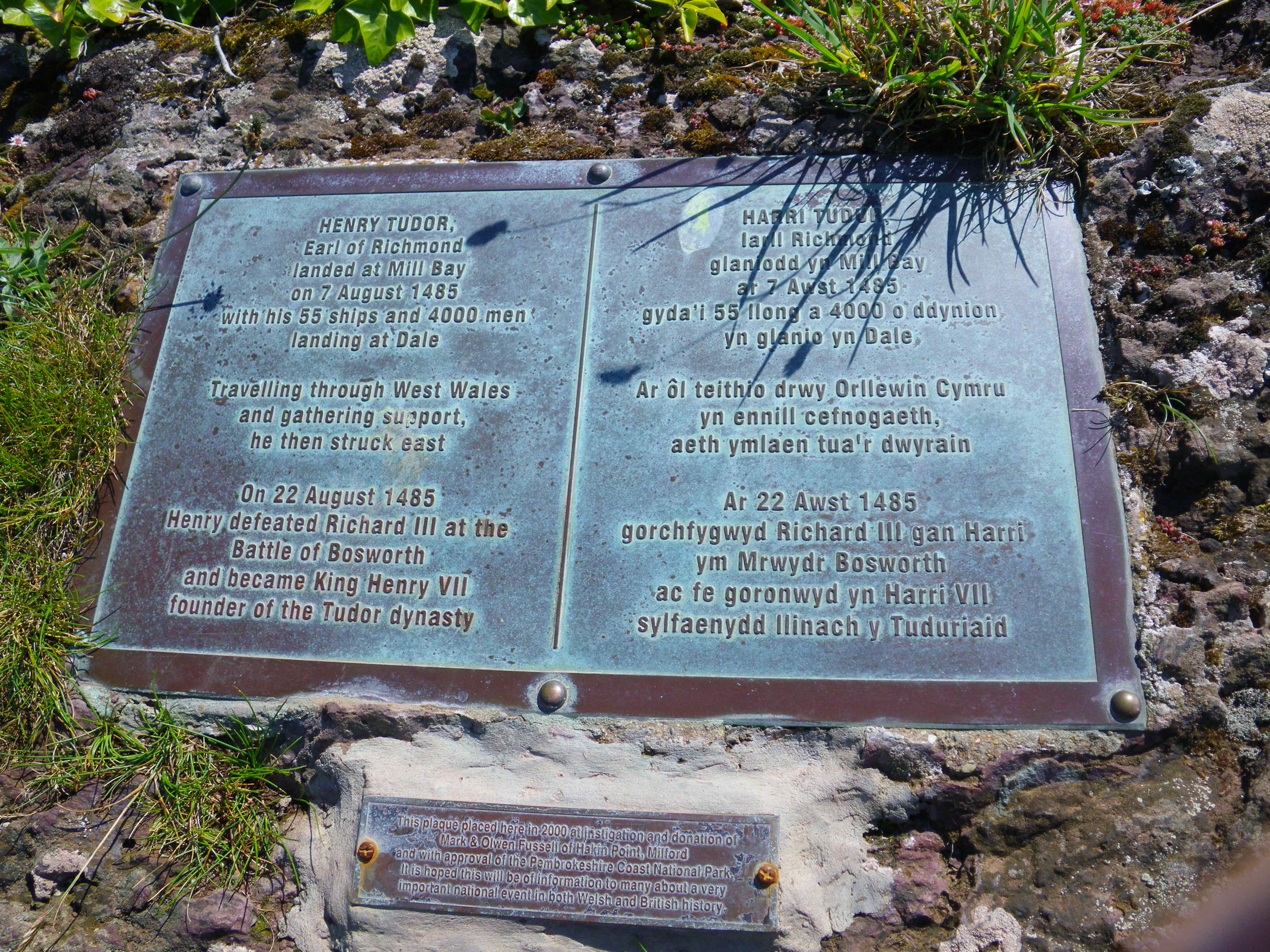
- Henry VII
- Black Bart (pirate)
- Last invasion of UK (1797)
- Admiral Nelson
- Gordon of Khartoum
- Isambard Kingdom Brunel
- First flight to Ireland
- RM Lockley
- First footfall of Prince Charles on Welsh sand (1955)
- Sea Empress.
Nearest Towns: Saundersfoot, Tenby, Pembroke, Pembroke Dock, Neyland Milford Haven, Broad Haven, Solva, Goodwick, Fishguard and Newport (Pembrokeshire) are all on the Trail.
The City of St David’s is one mile away, Haverfordwest six miles, Cardigan two miles, Carmarthen 30 miles Swansea 50 miles, Cardiff 90 miles.
Access: Roads – M4, A40 & A477. Cardiff to Carmarthen 2 hours by train (Cardiff to Tenby 2.5 hours, bus back to Amroth 40 mins). Trains also go to Haverfordwest, Pembroke Dock, Milford Haven and Fishguard Harbour.
Bus: Carmarthen to Amroth via Pendine –1 hour. Carmathen to Cardigan – 1.75 hours. More buses to parts of the Trail from Haverfordwest. Walker or service buses cover most of the coast. Details from website or Pembrokeshire County Council enquiry line 01437 775227.
Start-Finish Points: South – The bridge east of Amroth Castle. North – The slipway north of St Dogmaels, Cardigan (the north plaque is at Poppit Sands)
Information: National Trail guide by Brian John – Aurum Press ISBN =978-84513-563-8.
Part of the Wales Coast Path and the International Appalachian Trail.
Links to the Ceredigion Coast Path in the North and the Carmarthen Bay Coast Path in the South,
For more information contact us via Pembrokeshire Coast National Park, Llanion Park, Pembroke Dock, Pembrokeshire, SA726DY, call 01646 624800 or email pcp@pembrokeshirecoast.org.uk.
"
}
["row_4_image_left"]=>
bool(false)
["row_4_image_right"]=>
bool(false)
["block_chooser"]=>
array(2) {
[0]=>
array(7) {
["choose_block_type"]=>
string(21) "primary_message_block"
["call_to_action_block"]=>
array(7) {
["image"]=>
bool(false)
["title"]=>
string(0) ""
["text"]=>
string(0) ""
["internal_or_external_link"]=>
string(8) "internal"
["internal_link"]=>
NULL
["external_link"]=>
string(0) ""
["link_title"]=>
string(9) "Read More"
}
["combi_grid_block"]=>
array(6) {
["icon"]=>
bool(false)
["title"]=>
string(0) ""
["internal_or_external_link"]=>
array(4) {
["internal_or_external_link"]=>
string(8) "internal"
["internal_link"]=>
NULL
["external_link"]=>
string(0) ""
["link_title"]=>
string(9) "Read More"
}
["slot_rules"]=>
string(7) "small_4"
["slot_count"]=>
int(4)
["slots"]=>
array(4) {
["slot_population"]=>
string(4) "self"
["choose_parent_page"]=>
bool(false)
["slot_count"]=>
int(0)
["manual"]=>
bool(false)
}
}
["feature_content_block"]=>
array(7) {
["image"]=>
bool(false)
["title"]=>
string(0) ""
["intro_text"]=>
string(0) ""
["text"]=>
string(0) ""
["internal_or_external_link"]=>
array(4) {
["internal_or_external_link"]=>
string(8) "internal"
["internal_link"]=>
NULL
["external_link"]=>
string(0) ""
["link_title"]=>
string(9) "Read More"
}
["slot_count"]=>
int(6)
["slots"]=>
array(4) {
["slot_population"]=>
string(4) "self"
["choose_parent_page"]=>
bool(false)
["slot_count"]=>
int(0)
["manual"]=>
bool(false)
}
}
["primary_message_block"]=>
array(7) {
["slot_layout"]=>
string(4) "left"
["slot"]=>
string(4) "page"
["choose_page"]=>
int(9189)
["choose_parent_page"]=>
bool(false)
["manual"]=>
array(8) {
["image"]=>
bool(false)
["label"]=>
string(0) ""
["title"]=>
string(0) ""
["text"]=>
string(0) ""
["internal_or_external_link"]=>
string(8) "internal"
["internal_link"]=>
NULL
["external_link"]=>
string(0) ""
["link_title"]=>
string(9) "Read More"
}
["file"]=>
array(5) {
["image"]=>
bool(false)
["title"]=>
string(0) ""
["text"]=>
string(0) ""
["file"]=>
bool(false)
["link_title"]=>
string(8) "Download"
}
["cta"]=>
array(7) {
["image"]=>
bool(false)
["title"]=>
string(0) ""
["text"]=>
string(0) ""
["internal_or_external_link"]=>
string(8) "internal"
["internal_link"]=>
NULL
["external_link"]=>
string(0) ""
["link_title"]=>
string(9) "Read More"
}
}
["profile_grid_block"]=>
array(2) {
["title"]=>
string(0) ""
["profile"]=>
bool(false)
}
["mailchimp_block"]=>
array(4) {
["title"]=>
string(0) ""
["text"]=>
string(0) ""
["mailchimp_shortcode_english"]=>
string(0) ""
["mailchimp_shortcode_welsh"]=>
string(0) ""
}
}
[1]=>
array(7) {
["choose_block_type"]=>
string(16) "combi_grid_block"
["call_to_action_block"]=>
array(7) {
["image"]=>
bool(false)
["title"]=>
string(0) ""
["text"]=>
string(0) ""
["internal_or_external_link"]=>
string(8) "internal"
["internal_link"]=>
NULL
["external_link"]=>
string(0) ""
["link_title"]=>
string(9) "Read More"
}
["combi_grid_block"]=>
array(6) {
["icon"]=>
string(7) "icon_12"
["title"]=>
string(48) "Discover more about the Pembrokeshire Coast Path"
["internal_or_external_link"]=>
array(4) {
["internal_or_external_link"]=>
string(8) "internal"
["internal_link"]=>
NULL
["external_link"]=>
string(0) ""
["link_title"]=>
string(9) "Read More"
}
["slot_rules"]=>
string(7) "small_8"
["slot_count"]=>
string(1) "8"
["slots"]=>
array(4) {
["slot_population"]=>
string(6) "parent"
["choose_parent_page"]=>
int(9220)
["slot_count"]=>
string(1) "0"
["manual"]=>
bool(false)
}
}
["feature_content_block"]=>
array(7) {
["image"]=>
bool(false)
["title"]=>
string(0) ""
["intro_text"]=>
string(0) ""
["text"]=>
string(0) ""
["internal_or_external_link"]=>
array(4) {
["internal_or_external_link"]=>
string(8) "internal"
["internal_link"]=>
NULL
["external_link"]=>
string(0) ""
["link_title"]=>
string(9) "Read More"
}
["slot_count"]=>
int(6)
["slots"]=>
array(4) {
["slot_population"]=>
string(4) "self"
["choose_parent_page"]=>
bool(false)
["slot_count"]=>
int(0)
["manual"]=>
bool(false)
}
}
["primary_message_block"]=>
array(7) {
["slot_layout"]=>
string(4) "left"
["slot"]=>
string(4) "page"
["choose_page"]=>
bool(false)
["choose_parent_page"]=>
bool(false)
["manual"]=>
array(8) {
["image"]=>
bool(false)
["label"]=>
string(0) ""
["title"]=>
string(0) ""
["text"]=>
string(0) ""
["internal_or_external_link"]=>
string(8) "internal"
["internal_link"]=>
NULL
["external_link"]=>
string(0) ""
["link_title"]=>
string(9) "Read More"
}
["file"]=>
array(5) {
["image"]=>
bool(false)
["title"]=>
string(0) ""
["text"]=>
string(0) ""
["file"]=>
bool(false)
["link_title"]=>
string(8) "Download"
}
["cta"]=>
array(7) {
["image"]=>
bool(false)
["title"]=>
string(0) ""
["text"]=>
string(0) ""
["internal_or_external_link"]=>
string(8) "internal"
["internal_link"]=>
NULL
["external_link"]=>
string(0) ""
["link_title"]=>
string(9) "Read More"
}
}
["profile_grid_block"]=>
array(2) {
["title"]=>
string(0) ""
["profile"]=>
bool(false)
}
["mailchimp_block"]=>
array(4) {
["title"]=>
string(0) ""
["text"]=>
string(0) ""
["mailchimp_shortcode_english"]=>
string(0) ""
["mailchimp_shortcode_welsh"]=>
string(0) ""
}
}
}
}