Below are some of the most frequently asked questions about the Pembrokeshire Coast Path National Trail.
Each question is answered in detail lower down on this page but if you follow the ten steps below you may avoid some of the common problems walkers face on the Pembrokeshire Coast Path.
- Wear boots with a grip and ankle support.
- Carry spare clothing and waterproofs regardless of what the weather forecast says.
- Always check tide tables to ensure you don’t have to make unnecessary detours.
- Never climb cliffs without proper climbing equipment and the training and skills to use it.
- Carry water and some high energy food.
- Match what you are setting out to do with your abilities; build up to a challenge rather than trying for it on the first day.
- Always leave details of your proposed trip with a third party. Include start and finish points, time of departure and expected time of arrival, number of people etc. An alarm can be raised if you fail to turn up at the expected time or there is any kind of concern.
- Do not be tempted to stand or sit on the cliff edge to admire the view; it may crumble under your weight.
- Although GPS devices and apps can be helpful, an Ordnance Survey map can help you identify your location if you are in trouble on the Coast Path. It will assist the Emergency Services to locate you quickly if you can provide a Grid Reference of your position. You will also notice we have added location information on small white plaques approximately every quarter mile. If you get into trouble or are injured and require assistance on the Coast Path or beaches, ring 999 and ask for Coastguard.
- Dog walking: dogs can get into trouble whilst exploring, so always keep them on a lead near cliff edges and livestock. If they get struck on a ledge, in mud or swept out to sea, don’t go after them.
Frequently asked questions
1. How long will it take me to walk the full route?
The official guidebook recommends a 12 day route (at around 15 miles each day).
This is quite a challenging pace day after day, so it’s worth planning some rest days or taking longer and reducing the daily mileage.
Our ‘Planning Your Walk’ section divides the Path into 15 sections but also has information on inland path junctions so you can plan your own program.
You could even spread the walk over a series of visits and use the Coast Path Challenge leaflet to keep track of your progress.
2. OK – so how long is it really?
The Coast Path is 186 miles (299km) but with all the alternative routes for high tides, storm and firing ranges, the total maintained length is over 193 miles (312km). Along with detours to headlands, services and accommodation the figure will be considerably more.
3. How do I follow the Pembrokeshire Coast Path National Trail?
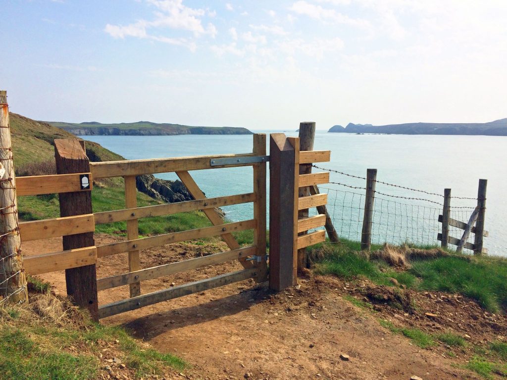
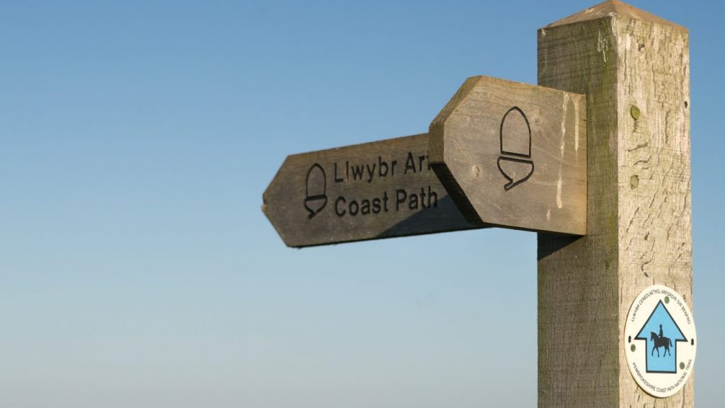
The Pembrokeshire Coast Path is well signposted throughout. You will see the distinctive acorn symbol on stiles, gates, signposts and lampposts through towns. This is the symbol used by all the English and Welsh National Trails.
The signposts may also include the words ‘Coast Path’ and distance and destination information or the Wales Coast Path logo which follows the same route through Pembrokeshire.
The Coast Path passes through a number of towns and villages. Although there are several routes you can take through towns and villages, the official route is signed with white acorn waymarks sometimes stuck high up on lampposts and other street furniture.
You will need to check your map carefully to make sure you leave the town on a road that leads onto the Path.
4. Can I use the Coast Path for short walks?
Yes. There are many sections that make a good circular or ‘there and back’ walk.
You can also make use of the coastal buses if you are travelling by car, why not drive to the end of your walk and catch a bus back to the start to complete the walk at your leisure. Elsewhere on the Pembrokeshire Coast National Park Authority website there are around 200 circular walks with free downloadable maps. Many of these routes are based on the Coast Path. Select ‘Coast Path’ from the Walk Type filter to view the circular walks that include a part of the Pembrokeshire Coast Path National Trail.
5. Are there guidebooks and maps I can use to help me plan my route?
Yes. There are many guidebooks available but the official guidebook (link opens TheTrailsShop website) by Brian John has colour extracts from the Ordnance Survey’s Explorer series at 1:25,000 showing points along the route cross-referenced to the text. The route is described from north to south. Other guides will describe the walk south to north so you can buy one to suit your direction of travel.
The Ordnance Survey (OS) Explorer Maps (1:25,000 scale with orange covers) is a perfect companion for walkers. They show footpaths, bridleways and trails, landscape features and places of interest. Pembrokeshire is covered by two maps, with the overlap at Newgale.
- Explorer OL35 North Pembrokeshire (view on Ordnance Survey website)
- Explorer OL36 South Pembrokeshire (view on Ordnance Survey website)
You can purchase guides and maps from many retailers including local book shops, the National Trail shop and the OS website, as well as from National Park Authority visitor centres at Oriel y Parc in St Davids, Carew Castle and Castell Henllys Iron Age Village.
6. How do I get to the Pembrokeshire Coast Path and around the area using public transport?
To Amroth (the southern end of the Coast Path) take a train to Kilgetty and then catch the 351 bus to Amroth (5km).
To St Dogmaels (the northern end of the Coast Path) get a train to Haverfordwest then the T5 bus to Cardigan or from Carmarthen bus station take the 460 bus to Cardigan. Then take the 405 walker bus (Poppit Rocket) or walk to St Dogmaels 1.5 miles (2.5km), you can stay on the Poppit Rocket bus to Poppit Sands to avoid extra road walking.
Trains on the northern line meet the Coast Path at Fishguard Harbour (Goodwick); on the western line at Milford Haven; on the southern line at Pembroke Dock, Penally and at Tenby.
All of the train lines mentioned go through Whitland Station, it may be cheaper to get a return ticket to Whitland and singles to from the destinations.
Visit the Pembrokeshire County Council website for information on local public transport, including route maps, timetables for services including the coastal buses.
Fflecsi Pembrokeshire is an on demand transport service. The fflecsi services run different routes each day to ensure that all people in the area can use the service. Trips must be booked in advance.
The different zones cover locations on the coast from Fishguard to Neyland. Visit the Fflecsi website for more information and to book the service.
7. Where can I park my car?
All parking is at your own risk and prices are subject to change.
Pembrokeshire County Council Car Parks
- The Pembrokeshire County Council website car parks page (opens in new window) shows the location and charging details for Council run car parks.
- The County Council run a ‘Parking Passport Permit’ scheme for some of their long stay car parks that enables you to park in the long stay section of some of their car parks. For further details visit the Parking passport permit page on the Pembrokeshire County Council website (opens in new window) please allow 14 days for permits to be issued.
- There is a small car park in St Dogmaels village where a weekly ticket can be purchased. The payment machines in the car park only accept a maximum of 30 coins in one go but you can also use PayByPhone to pay online (opens in new window).
National Park Authority Car Parks
- View our parking page to see the location of the 14 National Park Authority charging car parks. The charging season runs from 15 March to 7 November each year. Pay and display machines take cash or you can pay online via PayByPhone (opens in new window). Phone coverage is limited in some car parks but you can purchase using PayByPhone (opens in new window) en route. Please note purchasing before you arrive does not guarantee a parking space will be available.
- For those looking to park for a week there is a £30 weekly ticket transferable between National Park car parks which can be bought at the pay and display machine (not transferrable via PayByPhone). The National Park Authority also provides season tickets at £50 for any single nominated charging car park, or a £140 season ticket which enables you to move between all National Park car parks. Season tickets must be pre-purchased so ensure you allow time for processing and postage.
National Trust Car Parks
- The National Trust operate a number of car parks close to the Pembrokeshire Coast Path. For more details please visit the National Trust website (opens in new window).
- You can also purchase tickets for National Trust car parks online via PayByPhone (opens in new window).
Alternative options:
- Some accommodation providers or campsites around the coast will allow you to park a car for a small charge.
8. Are there ‘baggage transfer’ or ‘self-guided’ and ‘guided’ walks services?
Yes. Please note inclusion on the list is for general information only, it is not exhaustive and it does not constitute a recommendation.
Taxis and Baggage Transfer
Pembrokeshire Self Guided and Guided Walking Holidays from VIP Wales
Walkalongway | Walking Holidays in Pembrokeshire & West Wales
St Davids
- Morgan’s Taxis: 07788 292976
- Franks Cabs: 01437 721731 / 07974 391522
Haverfordwest
- Preseli Taxis / 01437 764050
- Clarks Taxis / 01437 710077
- Hughes Taxis / 07944 279 571
Self-guided walks (some including baggage transfer)
- VIP Wales 07496 057269/01239 920142
- Celtic Trails 01291 689 774
- Encounter Walking Holidays – 01208 871066
- HF Holidays 0845 470 8558
- Byways Breaks
- Contours Walking Holidays 01629 5741829
- Drover Holidays 01497 821134
- The Walking Holiday Company
- Absolute Escapes
- Mickledore
- Hillwalk Tours
- Walkalongway
- Discerning Traveller
- Discovery Travel
9. How can I find accommodation near the National Trail?
Pembrokeshire offers a host of accommodation options from contemporary hotels, B&Bs, self-catering cottages, bunkhouses, hostels, caravan and/or campsites. Accommodation varies from area to area with some having very limited options making it difficult to find last minute, so we would urge you to book ahead.
There are a couple of well positioned YHA hostels close to the trail at Poppit Sands, Newport, Pwll Deri, St Davids, Broadhaven and Manorbier. Visit the YHA website for further information.
Once you know what area you want to stay a quick web search may highlight more options. The National Trails website and Visit Pembrokeshire website show accommodation options on a map.
You might also consider staying in one location for a number of nights and using the coastal bus service to get around, but please note there are different winter and summer timetables. For the most up-to-date public transport timetables visit the Pembrokeshire County Council website.
10. Is wild camping allowed?
No. Nearly all the land the Coast Path passes through is in private ownership. Camping without the landowner’s permission (wild camping) is a trespass against the owner. There are many campsites along the Coast Path. Many are small so booking is essential if you intend to visit during bank holiday weekends or between June and September. Some sites will only be open for short periods during the summer months but they may not be widely promoted.
11. Is the Pembrokeshire Coast Path National Trail always open?
Most of the Coast Path is open all year round however there are times when access may be restricted.
Tides
Parts of the route will be impassable at high tide and as you walk the Coast Path you might also like to explore the many beaches and coves which are only be accessible at low tide.
The two main tidal crossings are between Dale and Milford Haven. One is at Sandy Haven and the other at Pickleridge/The Gann near Dale. Both are covered for over six hours every tide. There are alternative routes available but they involve a long walk along roads, so if possible, plan your trip to take this into account.
The Sandy Haven crossing is passable 2.5-3 hours each side of low tide, the Gann 3-3.5 hours each side of low tide. In order to be sure of walking safely across both tidal inlets in one go, you need to get to the first one as the tide is dropping from it and you then have 6 hours to get across the second one. The distance between the two crossings is just under 6 miles, so depending on the speed you walk, we would suggest you allow about 2 ½ hours between crossings. This will vary between neap and spring tides and will also be affected if weather conditions result in an intense low pressure system. If you start as the tide drops, you may just have to wait a little for it to be passable without getting wet.
There are also a number of minor tidal crossings which may be impassable for up to an hour or so on the highest Spring tides. It is best to just wait until the water level drops. These are:
- Between Iron Bridge, Newport and Newport Sands – only on the highest of spring tides.
- Quoits Mill just west of Monkton, Pembroke – road floods when the tide is over 6.5 metres. The flooded stretch is up to 200 metres long, the only alternative is a road, which we would not recommend for walkers. Best to plan your trip or wait for the tide to drop.
- Pwllcrochan, Hundleton – only on the highest Spring tides
- Point House Lane, Angle – only on Spring tides.
- Little Wick (South Hook) beach, west of Milford Haven – only on the highest Spring tides.
- Castle Pond Pembroke – only on the highest spring tides.
Take care as the tidal crossings may be slippery!
You can download the latest tide tables from the Port of Milford Haven website (Times are set to Greenwich Mean Time, so don’t forget to add one hour between the last Sunday in March and last Sunday in October). You can also find tide tables from April to October in our visitor newspaper Coast to Coast.
Access to military Ranges
The Coast Path passes through or around three military training areas where use by the public is sometimes restricted. Care must be exercised within these areas at all times – you must keep to the footpath, stay away from all installations and avoid approaching or touching any objects lying on the ground. Manorbier Range doesn’t affect the passage of walkers but Castlemartin and Penally ranges do.
- Access is normally available at the weekends, public holidays and throughout August but this can change so check the timetables to be sure. Timetables can be found up to two months in advance with a quick search for Penally Gallery Range or Castlemartin Range firing notices on the Gov.uk website.
- Please note that very occasionally Castlemartin may close at short notice so it is best to check with the recorded information on 01646 662367 the day before you travel.
- When closed, red flags will be flying and soldiers and sentry guards will patrol key access points.
Penally
There is a short and easy to follow alternative route for the National Trail.
Castlemartin
- Provided there is no night firing, Castlemartin Range will usually open by around 4.30pm on firing days.
- When the range is closed there is a permissive bridleway provided by the Ministry of Defence called the ‘Castlemartin Range Trail’ (marked with a tank waymark) it is open all year to provide a route around the perimeter of the range and is preferable to walking along the road. Details of the Range Trail route can be found on our website page Castlemartin Range Trail
- Castlemartin Range has some spectacular limestone cliffs, very popular with climbers. It is worth checking the firing notice to see if the section east of St Govan’s is available even if the St Govan’s to Stack Rocks section is closed so that you can walk part of the area.
Do not be overly concerned by the detours caused by the military ranges as good, signed alternative routes are available. More attention needs to be paid to the detours caused by the tidal inlets at Dale and Sandy Haven (see above).
Temporary diversions
Sometimes diversions are put in place while maintenance work is carried out on sections of the Coast Path. Visit the Trail News section of the website for details of substantial diversions.
12. When is the best time of year to walk the Pembrokeshire Coast Path?
The Pembrokeshire Coast Path has something to offer all the year round and many people prefer to walk when it’s cooler in spring or autumn, or even on exhilarating winter days.
The best time depends very much on you, your interests (see below) and whether you enjoy the busy holiday season or would prefer to come during the quieter months. Even in the busier months remote sections can still be very quiet.
In summer it can be difficult to find accommodation especially for single nights, so you are advised to book well in advance. During the winter months weather conditions can change rapidly with high winds during storms and lack of visibility due to rain and fog making for dangerous conditions on the cliff tops.
Seasonal highlights include:
Migrating birds – spring and autumn;
Breeding birds – spring and summer;
Wildflowers – at their best during April and May;
Seal pups – autumn.
13. Which direction should I walk?
Many people walk the route from St Dogmaels in the north to Amroth in the south. Most of the guidebooks are written this way, as is the ‘Planning your walk’ section of this website.
There is no right or wrong way – plenty of people enjoy walking it in the other direction, and there are guide books written in both directions. For more information visit our ‘North to south or south to north?’ page.
14. What equipment do I need?
Although the Coast Path is well signposted we recommend that you take a map or guidebook with you.
Proper walking boots with ankle support are recommended as the Coast Path is uneven and rugged in places and after rain can be muddy. Consider using walking poles to help on rough terrain.
The weather can change rapidly on the coast so it’s wise to be prepared. You’ll need good waterproofs including trousers, warm layers and a sun hat. Sunblock is advisable even on dull days. Take plenty of water (around a litre) as there are no refill options on some of the longer stretches.
We don’t recommend drinking from streams even with a filter.
If you are walking alone you may want to tell someone where you are going as mobile phone coverage can be unreliable. Ensure your phone is fully charged before setting off.
15. Can I bring my dog with me on the National Trail?
Your dog is welcome on the Coast Path as long as it is kept under close control. This is important for the welfare of your dog and the wildlife and farm animals on the Coast Path.
Unfortunately each year some dogs fall off the cliff edge, while chasing wildlife or livestock. Where a dog can be rescued this puts an additional strain on the Coastguard and RNLI.
We have changed many stiles to gates and installed dog gates on some stiles. However, there are 11 stiles that your dog will have to climb or be lifted over.
Be aware that some sections of the Coast Path pass through farms where livestock may be grazing. Sadly, there have been incidents of cattle and sheep being chased over the cliff edge by uncontrolled dogs so keeping your dog on a lead is the best precaution.
Some beaches have restrictions or partial restrictions from May-September; please see on-site signage for details or visit our Walking your dog page. Other reasons to keep you dog under control is to prevent disturbance to seals on beaches and avoid coming into contact with adders whose venomous bite can be very serious for small dogs.
16. Can I ride my horse or bike on the Pembrokeshire Coast Path National Trail?
In most places – no – the majority of the Coast Path is only available to people on foot. This is because nearly all of it is a public footpath rather than a public bridleway. Apart from the bridleway sections the Coast Path is not maintained for cycling and its unlawful use by cyclist is both a danger to the cyclists and other walkers due to the narrow paths and unguarded cliff.
The exceptions are the bridleway section between Stack Rocks and St Govans and parts of the Trail between Amroth and Saundersfoot which are cycleways.
17. Will I be able to get refreshments?
The towns and villages along the coast have a good selection of pubs, cafes, restaurants and shops. Some of these close in the winter. For more information on places to eat and drink see the Visit Pembrokeshire website.
There are some quite long sections without a sizeable village. It’s important to plan ahead and carry plenty of food and water on these sections.
Some public toilets along the coast provide drinking water either inside or on the outside of the buildings. To see the location of public toilets visit the Pembrokeshire County Council website.
You will also find a number of cafes, bars, restaurants, galleries, campsite and other businesses will be happy to fill up a bottle for free. A new water refill app has just been launched with a limited number of locations so far but it is growing. There will be many business not listed who are happy to refill a bottle. To download the app please visit the Refill website.
Please note that some water refill points may be unavailable due to Covid-19. Therefore it is more important than ever that you plan ahead to ensure you have plenty of water for your trip.
18. What is the record for running the Coast Path? I want to beat it!
Many people challenge themselves to complete the Path in the fastest time, but due to the uneven terrain, steep slopes and sheer cliffs we don’t actively promote running on the Coast Path. In order to protect walkers we have produced guidance for running on the Coast Path.
19. Who owns the Coast Path?
Most of the land that the Coast Path crosses is privately owned by many different individuals and estates. We estimate that if you walk the entire length you will pass through 180 separate land holdings.
The Coast Path runs along registered public rights of way for the most part. This means that you have a legal right to walk across the land as long as you and your dog keep to the Path. For further advice visit our Countryside Code page.
20. My mobile phone will get me out of trouble won’t it?
No it won’t! Walkers are advised that network coverage signal is unreliable on much of the coast. We would encourage visitors to rely on their own equipment and skills and to plan ahead as much as possible. In case of an emergency there is location information (grid reference numbers) on small plaques approximately every quarter mile attached to gates, stiles, signposts and sometimes fence posts. If you call the Coast Guard for assistance, this information will assist them to find you.
21. Can I claim a certificate for completing the whole Coast Path?
Before you start, print off our Coast Path Challenge leaflet or pick one up from the National Park Visitor Centre in St Davids.
Complete and return the form to the address on the leaflet and we will send you a free certificate. You can also choose to buy a special cloth badge at a cost of £5 only available to those completing the entire route of the Coast Path.