array(7) {
["slot_text_override"]=>
string(0) ""
["theme"]=>
string(7) "theme_1"
["microsite_subtitle"]=>
string(49) "along the Pembrokeshire Coast Path National Trail"
["detail_top"]=>
array(9) {
[""]=>
NULL
["intro_text"]=>
string(158) "The Pembrokeshire Coast Path winds its way across a variety of landscapes, from high cliff tops and secret coves to sweeping estuaries and wide sandy beaches."
["row_1_text_left"]=>
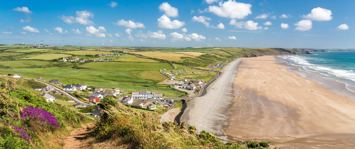
string(332) "
The highest point is at Pen yr Afr near Ceibwr Bay, where the sea-sprayed cliffs reach 1,500 feet. This northern stretch of the Path from St Dogmael’s to St David’s Head is the wildest and most remote section, with the occasional coastal community, such as those at Newport, Fishguard and Porthgain, adding to the charm.
"
["row_1_text_right"]=>
string(277) "
On the western-facing edge, Atlantic breakers crash onto the wide beaches of Newgale and Broad Haven in the curve of St Bride’s Bay. From this section of the Path the sky is big and there are often spectacular views to the bird-encircled islands of Ramsey and Skomer.
"
["row_2_title"]=>
string(0) ""
["row_2_text"]=>
string(979) "
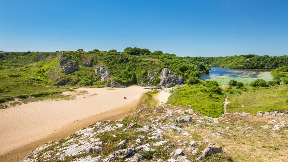
The Path along the Milford Haven estuary offers huge contrasts from the wild seascape at St Anne’s Head, through the industrial hub around Milford Haven to the calmer waters of the upper reaches of the waterway. This famous natural harbour is a ria – a drowned river valley formed as a result of rising sea levels at the end of the last Ice Age.
The southern section is the most used as it is closest to the popular holiday resorts of Tenby and Saundersfoot. But even along this south-facing rim there are miles of secluded cliff walks and sheltered beaches. Check out the lily ponds at Bosherston and the golden sands of Barafundle – frequently voted one of the best beaches in the world.
Inland from wherever you are along the Path you will see flat and gently undulating farmland. It may be just a step away from the coast but this agricultural countryside also has its own unique habitats and ecosystems giving walkers the best of both worlds.
"
["row_2_image"]=>
array(24) {
["ID"]=>
int(6580)
["id"]=>
int(6580)
["title"]=>
string(25) "58 - Broad Haven South 01"
["filename"]=>
string(42) "58-Broad-Haven-South-01-e1570535554308.jpg"
["filesize"]=>
int(164122)
["url"]=>
string(106) "https://www.pembrokeshirecoast.wales/wp-content/uploads/2019/10/58-Broad-Haven-South-01-e1570535554308.jpg"
["link"]=>
string(125) "https://www.pembrokeshirecoast.wales/things-to-do/walking-in-the-park/web-walks/bosherston-st-govans/58-broad-haven-south-01/"
["alt"]=>
string(51) "Bosherston Lily Ponds viewed from Broad Haven South"
["author"]=>
string(2) "48"
["description"]=>
string(98) "Bosherston Lily Ponds viewed from Broad Haven South, Pembrokeshire Coast National Park, Wales, UK."
["caption"]=>
string(51) "Bosherston Lily Ponds viewed from Broad Haven South"
["name"]=>
string(23) "58-broad-haven-south-01"
["status"]=>
string(7) "inherit"
["uploaded_to"]=>
int(6579)
["date"]=>
string(19) "2019-10-08 11:51:35"
["modified"]=>
string(19) "2019-10-08 11:52:10"
["menu_order"]=>
int(0)
["mime_type"]=>
string(10) "image/jpeg"
["type"]=>
string(5) "image"
["subtype"]=>
string(4) "jpeg"
["icon"]=>
string(73) "https://www.pembrokeshirecoast.wales/wp-includes/images/media/default.png"
["width"]=>
int(1100)
["height"]=>
int(618)
["sizes"]=>
array(69) {
["thumbnail"]=>
string(114) "https://www.pembrokeshirecoast.wales/wp-content/uploads/2019/10/58-Broad-Haven-South-01-e1570535554308-150x150.jpg"
["thumbnail-width"]=>
int(150)
["thumbnail-height"]=>
int(150)
["medium"]=>
string(114) "https://www.pembrokeshirecoast.wales/wp-content/uploads/2019/10/58-Broad-Haven-South-01-e1570535554308-300x169.jpg"
["medium-width"]=>
int(300)
["medium-height"]=>
int(169)
["medium_large"]=>
string(114) "https://www.pembrokeshirecoast.wales/wp-content/uploads/2019/10/58-Broad-Haven-South-01-e1570535554308-768x431.jpg"
["medium_large-width"]=>
int(768)
["medium_large-height"]=>
int(431)
["large"]=>
string(115) "https://www.pembrokeshirecoast.wales/wp-content/uploads/2019/10/58-Broad-Haven-South-01-e1570535554308-1024x575.jpg"
["large-width"]=>
int(1024)
["large-height"]=>
int(575)
["1536x1536"]=>
string(106) "https://www.pembrokeshirecoast.wales/wp-content/uploads/2019/10/58-Broad-Haven-South-01-e1570535554308.jpg"
["1536x1536-width"]=>
int(1100)
["1536x1536-height"]=>
int(618)
["2048x2048"]=>
string(106) "https://www.pembrokeshirecoast.wales/wp-content/uploads/2019/10/58-Broad-Haven-South-01-e1570535554308.jpg"
["2048x2048-width"]=>
int(1100)
["2048x2048-height"]=>
int(618)
["featured-small-home"]=>
string(114) "https://www.pembrokeshirecoast.wales/wp-content/uploads/2019/10/58-Broad-Haven-South-01-e1570535554308-640x422.jpg"
["featured-small-home-width"]=>
int(640)
["featured-small-home-height"]=>
int(422)
["featured-medium-home"]=>
string(106) "https://www.pembrokeshirecoast.wales/wp-content/uploads/2019/10/58-Broad-Haven-South-01-e1570535554308.jpg"
["featured-medium-home-width"]=>
int(1100)
["featured-medium-home-height"]=>
int(618)
["featured-large-home"]=>
string(106) "https://www.pembrokeshirecoast.wales/wp-content/uploads/2019/10/58-Broad-Haven-South-01-e1570535554308.jpg"
["featured-large-home-width"]=>
int(1100)
["featured-large-home-height"]=>
int(618)
["featured-xlarge-home"]=>
string(106) "https://www.pembrokeshirecoast.wales/wp-content/uploads/2019/10/58-Broad-Haven-South-01-e1570535554308.jpg"
["featured-xlarge-home-width"]=>
int(1100)
["featured-xlarge-home-height"]=>
int(618)
["featured-small"]=>
string(114) "https://www.pembrokeshirecoast.wales/wp-content/uploads/2019/10/58-Broad-Haven-South-01-e1570535554308-640x234.jpg"
["featured-small-width"]=>
int(640)
["featured-small-height"]=>
int(234)
["featured-medium"]=>
string(115) "https://www.pembrokeshirecoast.wales/wp-content/uploads/2019/10/58-Broad-Haven-South-01-e1570535554308-1100x468.jpg"
["featured-medium-width"]=>
int(1100)
["featured-medium-height"]=>
int(468)
["featured-large"]=>
string(115) "https://www.pembrokeshirecoast.wales/wp-content/uploads/2019/10/58-Broad-Haven-South-01-e1570535554308-1100x505.jpg"
["featured-large-width"]=>
int(1100)
["featured-large-height"]=>
int(505)
["featured-xlarge"]=>
string(100) "https://www.pembrokeshirecoast.wales/wp-content/uploads/2019/10/58-Broad-Haven-South-01-1200x703.jpg"
["featured-xlarge-width"]=>
int(1200)
["featured-xlarge-height"]=>
int(703)
["gd-pem-small"]=>
string(114) "https://www.pembrokeshirecoast.wales/wp-content/uploads/2019/10/58-Broad-Haven-South-01-e1570535554308-640x360.jpg"
["gd-pem-small-width"]=>
int(640)
["gd-pem-small-height"]=>
int(360)
["gd-pem-medium"]=>
string(115) "https://www.pembrokeshirecoast.wales/wp-content/uploads/2019/10/58-Broad-Haven-South-01-e1570535554308-1024x575.jpg"
["gd-pem-medium-width"]=>
int(1024)
["gd-pem-medium-height"]=>
int(575)
["gd-pem-large"]=>
string(106) "https://www.pembrokeshirecoast.wales/wp-content/uploads/2019/10/58-Broad-Haven-South-01-e1570535554308.jpg"
["gd-pem-large-width"]=>
int(1100)
["gd-pem-large-height"]=>
int(618)
["gd-pem-xlarge"]=>
string(106) "https://www.pembrokeshirecoast.wales/wp-content/uploads/2019/10/58-Broad-Haven-South-01-e1570535554308.jpg"
["gd-pem-xlarge-width"]=>
int(1100)
["gd-pem-xlarge-height"]=>
int(618)
["profile"]=>
string(114) "https://www.pembrokeshirecoast.wales/wp-content/uploads/2019/10/58-Broad-Haven-South-01-e1570535554308-600x600.jpg"
["profile-width"]=>
int(600)
["profile-height"]=>
int(600)
["post-thumbnail"]=>
string(114) "https://www.pembrokeshirecoast.wales/wp-content/uploads/2019/10/58-Broad-Haven-South-01-e1570535554308-125x125.jpg"
["post-thumbnail-width"]=>
int(125)
["post-thumbnail-height"]=>
int(125)
["woocommerce_thumbnail"]=>
string(114) "https://www.pembrokeshirecoast.wales/wp-content/uploads/2019/10/58-Broad-Haven-South-01-e1570535554308-300x169.jpg"
["woocommerce_thumbnail-width"]=>
int(300)
["woocommerce_thumbnail-height"]=>
int(169)
["woocommerce_single"]=>
string(114) "https://www.pembrokeshirecoast.wales/wp-content/uploads/2019/10/58-Broad-Haven-South-01-e1570535554308-598x336.jpg"
["woocommerce_single-width"]=>
int(598)
["woocommerce_single-height"]=>
int(336)
["woocommerce_gallery_thumbnail"]=>
string(114) "https://www.pembrokeshirecoast.wales/wp-content/uploads/2019/10/58-Broad-Haven-South-01-e1570535554308-100x100.jpg"
["woocommerce_gallery_thumbnail-width"]=>
int(100)
["woocommerce_gallery_thumbnail-height"]=>
int(100)
}
}
["row_3_title"]=>
string(0) ""
["row_3_text"]=>
string(0) ""
}
["row_4_image_left"]=>
bool(false)
["row_4_image_right"]=>
bool(false)
["block_chooser"]=>
array(1) {
[0]=>
array(7) {
["choose_block_type"]=>
string(16) "combi_grid_block"
["call_to_action_block"]=>
array(7) {
["image"]=>
bool(false)
["title"]=>
string(0) ""
["text"]=>
string(0) ""
["internal_or_external_link"]=>
string(8) "internal"
["internal_link"]=>
NULL
["external_link"]=>
string(0) ""
["link_title"]=>
string(9) "Read More"
}
["combi_grid_block"]=>
array(6) {
["icon"]=>
string(7) "icon_12"
["title"]=>
string(48) "Discover more about the Pembrokeshire Coast Path"
["internal_or_external_link"]=>
array(4) {
["internal_or_external_link"]=>
string(8) "internal"
["internal_link"]=>
NULL
["external_link"]=>
string(0) ""
["link_title"]=>
string(9) "Read More"
}
["slot_rules"]=>
string(7) "small_8"
["slot_count"]=>
string(1) "8"
["slots"]=>
array(4) {
["slot_population"]=>
string(6) "parent"
["choose_parent_page"]=>
int(9220)
["slot_count"]=>
string(1) "0"
["manual"]=>
bool(false)
}
}
["feature_content_block"]=>
array(7) {
["image"]=>
bool(false)
["title"]=>
string(0) ""
["intro_text"]=>
string(0) ""
["text"]=>
string(0) ""
["internal_or_external_link"]=>
array(4) {
["internal_or_external_link"]=>
string(8) "internal"
["internal_link"]=>
NULL
["external_link"]=>
string(0) ""
["link_title"]=>
string(9) "Read More"
}
["slot_count"]=>
int(6)
["slots"]=>
array(4) {
["slot_population"]=>
string(4) "self"
["choose_parent_page"]=>
bool(false)
["slot_count"]=>
int(0)
["manual"]=>
bool(false)
}
}
["primary_message_block"]=>
array(7) {
["slot_layout"]=>
string(4) "left"
["slot"]=>
string(4) "page"
["choose_page"]=>
bool(false)
["choose_parent_page"]=>
bool(false)
["manual"]=>
array(8) {
["image"]=>
bool(false)
["label"]=>
string(0) ""
["title"]=>
string(0) ""
["text"]=>
string(0) ""
["internal_or_external_link"]=>
string(8) "internal"
["internal_link"]=>
NULL
["external_link"]=>
string(0) ""
["link_title"]=>
string(9) "Read More"
}
["file"]=>
array(5) {
["image"]=>
bool(false)
["title"]=>
string(0) ""
["text"]=>
string(0) ""
["file"]=>
bool(false)
["link_title"]=>
string(8) "Download"
}
["cta"]=>
array(7) {
["image"]=>
bool(false)
["title"]=>
string(0) ""
["text"]=>
string(0) ""
["internal_or_external_link"]=>
string(8) "internal"
["internal_link"]=>
NULL
["external_link"]=>
string(0) ""
["link_title"]=>
string(9) "Read More"
}
}
["profile_grid_block"]=>
array(2) {
["title"]=>
string(0) ""
["profile"]=>
bool(false)
}
["mailchimp_block"]=>
array(4) {
["title"]=>
string(0) ""
["text"]=>
string(0) ""
["mailchimp_shortcode_english"]=>
string(0) ""
["mailchimp_shortcode_welsh"]=>
string(0) ""
}
}
}
}