array(6) {
["theme"]=>
string(7) "theme_1"
["microsite_subtitle"]=>
string(47) "St Dogmaels to Amroth or Amroth to St Dogmaels?"
["detail_top"]=>
array(9) {
[""]=>
NULL
["intro_text"]=>
string(219) "Most of the guides, are written as if one is walking from St Dogmael's to Amroth. The stiles and gates have numbers on with number one being near Pen Cemaes in the north. To walk this way gives a feeling of conformity. "
["row_1_text_left"]=>
string(267) "
If swimming is important to you, the best beaches are in the southern two-thirds of the walk. The sun moves around during the day and the path changes direction often. But when walking from Poppit the sun and usual south west-wind will be mostly on your face.
"
["row_1_text_right"]=>
string(310) "
Walking north to south may increase exposure from the sun during the summer and from the wind in Spring Autumn and Winter. Even during March and October the sun’s strength is magnified by the sea. On cool cloudy days you can still get burned on a two hour walk, therefore sun protection is important.
"
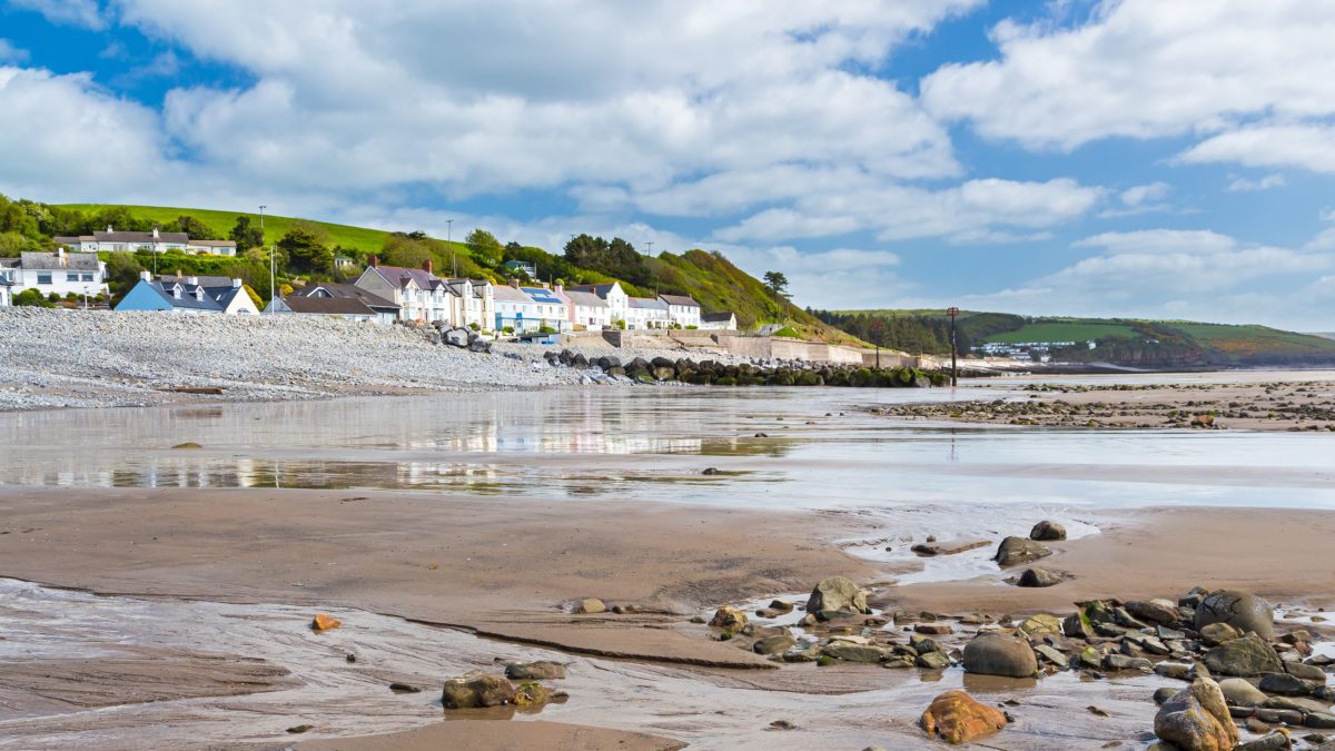
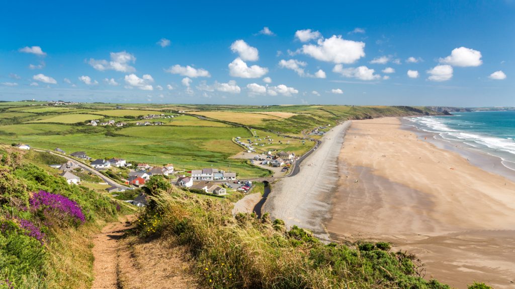
["row_2_title"]=>
string(21) "St Dogmaels to Amroth"
["row_2_text"]=>
string(539) "
When walking from north to south, the first day’s walk from St Dogmaels to Newport is around 16 miles and covers about 3,000 feet of ascent and descent.
There are no refreshments or services close to the Trail between the (seasonal-only) services of Poppit and Newport Sands.
This is the most challenging section of the Coast Path and not a walk for the unfit.
Novice walkers would be well advised to book accommodation in advance at Moylegrove and split this walk into two separate eight-mile stretches.
"
["row_2_image"]=>
array(24) {
["ID"]=>
int(1107)
["id"]=>
int(1107)
["title"]=>
string(32) "Amroth Beach Pembrokeshire Wales"
["filename"]=>
string(35) "amroth-477709924-e1569323775514.jpg"
["filesize"]=>
int(156984)
["url"]=>
string(99) "https://www.pembrokeshirecoast.wales/wp-content/uploads/2019/04/amroth-477709924-e1569323775514.jpg"
["link"]=>
string(117) "https://www.pembrokeshirecoast.wales/planning/planning-advice/permitted-development/amroth-beach-pembrokeshire-wales/"
["alt"]=>
string(111) "Photograph of seaside village of Amroth taken from the beach looking toward the row of houses on the sea front."
["author"]=>
string(2) "48"
["description"]=>
string(111) "Photograph of seaside village of Amroth taken from the beach looking toward the row of houses on the sea front."
["caption"]=>
string(57) "Beach and village at Amroth Pembrokeshire Wales UK Europe"
["name"]=>
string(32) "amroth-beach-pembrokeshire-wales"
["status"]=>
string(7) "inherit"
["uploaded_to"]=>
int(1105)
["date"]=>
string(19) "2019-04-17 10:51:09"
["modified"]=>
string(19) "2022-02-01 13:50:37"
["menu_order"]=>
int(0)
["mime_type"]=>
string(10) "image/jpeg"
["type"]=>
string(5) "image"
["subtype"]=>
string(4) "jpeg"
["icon"]=>
string(73) "https://www.pembrokeshirecoast.wales/wp-includes/images/media/default.png"
["width"]=>
int(1200)
["height"]=>
int(675)
["sizes"]=>
array(69) {
["thumbnail"]=>
string(107) "https://www.pembrokeshirecoast.wales/wp-content/uploads/2019/04/amroth-477709924-e1569323775514-150x150.jpg"
["thumbnail-width"]=>
int(150)
["thumbnail-height"]=>
int(150)
["medium"]=>
string(107) "https://www.pembrokeshirecoast.wales/wp-content/uploads/2019/04/amroth-477709924-e1569323775514-300x169.jpg"
["medium-width"]=>
int(300)
["medium-height"]=>
int(169)
["medium_large"]=>
string(107) "https://www.pembrokeshirecoast.wales/wp-content/uploads/2019/04/amroth-477709924-e1569323775514-768x432.jpg"
["medium_large-width"]=>
int(768)
["medium_large-height"]=>
int(432)
["large"]=>
string(108) "https://www.pembrokeshirecoast.wales/wp-content/uploads/2019/04/amroth-477709924-e1569323775514-1024x576.jpg"
["large-width"]=>
int(1024)
["large-height"]=>
int(576)
["1536x1536"]=>
string(99) "https://www.pembrokeshirecoast.wales/wp-content/uploads/2019/04/amroth-477709924-e1569323775514.jpg"
["1536x1536-width"]=>
int(1200)
["1536x1536-height"]=>
int(675)
["2048x2048"]=>
string(99) "https://www.pembrokeshirecoast.wales/wp-content/uploads/2019/04/amroth-477709924-e1569323775514.jpg"
["2048x2048-width"]=>
int(1200)
["2048x2048-height"]=>
int(675)
["featured-small-home"]=>
string(107) "https://www.pembrokeshirecoast.wales/wp-content/uploads/2019/04/amroth-477709924-e1569323775514-640x422.jpg"
["featured-small-home-width"]=>
int(640)
["featured-small-home-height"]=>
int(422)
["featured-medium-home"]=>
string(99) "https://www.pembrokeshirecoast.wales/wp-content/uploads/2019/04/amroth-477709924-e1569323775514.jpg"
["featured-medium-home-width"]=>
int(1200)
["featured-medium-home-height"]=>
int(675)
["featured-large-home"]=>
string(99) "https://www.pembrokeshirecoast.wales/wp-content/uploads/2019/04/amroth-477709924-e1569323775514.jpg"
["featured-large-home-width"]=>
int(1200)
["featured-large-home-height"]=>
int(675)
["featured-xlarge-home"]=>
string(99) "https://www.pembrokeshirecoast.wales/wp-content/uploads/2019/04/amroth-477709924-e1569323775514.jpg"
["featured-xlarge-home-width"]=>
int(1200)
["featured-xlarge-home-height"]=>
int(675)
["featured-small"]=>
string(107) "https://www.pembrokeshirecoast.wales/wp-content/uploads/2019/04/amroth-477709924-e1569323775514-640x234.jpg"
["featured-small-width"]=>
int(640)
["featured-small-height"]=>
int(234)
["featured-medium"]=>
string(108) "https://www.pembrokeshirecoast.wales/wp-content/uploads/2019/04/amroth-477709924-e1569323775514-1200x468.jpg"
["featured-medium-width"]=>
int(1200)
["featured-medium-height"]=>
int(468)
["featured-large"]=>
string(108) "https://www.pembrokeshirecoast.wales/wp-content/uploads/2019/04/amroth-477709924-e1569323775514-1200x505.jpg"
["featured-large-width"]=>
int(1200)
["featured-large-height"]=>
int(505)
["featured-xlarge"]=>
string(108) "https://www.pembrokeshirecoast.wales/wp-content/uploads/2019/04/amroth-477709924-e1555498906394-1200x703.jpg"
["featured-xlarge-width"]=>
int(1200)
["featured-xlarge-height"]=>
int(703)
["gd-pem-small"]=>
string(107) "https://www.pembrokeshirecoast.wales/wp-content/uploads/2019/04/amroth-477709924-e1569323775514-640x360.jpg"
["gd-pem-small-width"]=>
int(640)
["gd-pem-small-height"]=>
int(360)
["gd-pem-medium"]=>
string(108) "https://www.pembrokeshirecoast.wales/wp-content/uploads/2019/04/amroth-477709924-e1569323775514-1024x576.jpg"
["gd-pem-medium-width"]=>
int(1024)
["gd-pem-medium-height"]=>
int(576)
["gd-pem-large"]=>
string(99) "https://www.pembrokeshirecoast.wales/wp-content/uploads/2019/04/amroth-477709924-e1569323775514.jpg"
["gd-pem-large-width"]=>
int(1200)
["gd-pem-large-height"]=>
int(675)
["gd-pem-xlarge"]=>
string(99) "https://www.pembrokeshirecoast.wales/wp-content/uploads/2019/04/amroth-477709924-e1569323775514.jpg"
["gd-pem-xlarge-width"]=>
int(1200)
["gd-pem-xlarge-height"]=>
int(675)
["profile"]=>
string(107) "https://www.pembrokeshirecoast.wales/wp-content/uploads/2019/04/amroth-477709924-e1569323775514-600x600.jpg"
["profile-width"]=>
int(600)
["profile-height"]=>
int(600)
["post-thumbnail"]=>
string(107) "https://www.pembrokeshirecoast.wales/wp-content/uploads/2019/04/amroth-477709924-e1569323775514-125x125.jpg"
["post-thumbnail-width"]=>
int(125)
["post-thumbnail-height"]=>
int(125)
["woocommerce_thumbnail"]=>
string(107) "https://www.pembrokeshirecoast.wales/wp-content/uploads/2019/04/amroth-477709924-e1569323775514-300x169.jpg"
["woocommerce_thumbnail-width"]=>
int(300)
["woocommerce_thumbnail-height"]=>
int(169)
["woocommerce_single"]=>
string(107) "https://www.pembrokeshirecoast.wales/wp-content/uploads/2019/04/amroth-477709924-e1569323775514-598x336.jpg"
["woocommerce_single-width"]=>
int(598)
["woocommerce_single-height"]=>
int(336)
["woocommerce_gallery_thumbnail"]=>
string(107) "https://www.pembrokeshirecoast.wales/wp-content/uploads/2019/04/amroth-477709924-e1569323775514-100x100.jpg"
["woocommerce_gallery_thumbnail-width"]=>
int(100)
["woocommerce_gallery_thumbnail-height"]=>
int(100)
}
}
["row_3_title"]=>
string(21) "Amroth to St Dogmaels"
["row_3_text"]=>
string(4046) "
If walking from south to north, the first day provides many opportunities for refreshment and accommodation. The 16 mile stretch from Amroth to Skrinkle is quite a challenging day in itself.
There are many steep hills. But there is a pub at least every four miles, and many cafes. The town of Tenby has many choices for an early overnight if body or equipment are suffering.
Temporary restrictions to consider when planning which direction to walk
Access to military ranges
There are two military training areas along the south coast one at Penally and the other at Castlemartin which may restrict access when firing is taking place. Penally Range is a minor detour, slightly longer during times of very high tide or storm. This detour isn’t really worth planning for simply follow the signed alternative when the red flags are flying.
The Castlemartin Range is a minor aspect of planning direction of travel but if you are keen to stay as close to the cliffs as possible then it may be worth timing this section for a time when the range is open. The range is split into three sections. You can only cross Range West (not the official route of the Coast Path) as part of a walk guided by trained leaders.
Both the National Park Authority and Ramblers Association lead these walks. These walks usually go from east to west which fits well with walking the Coast Path from south to north however they are only available for a limited number of days through the summer and most Coast Path walkers follow the official route around the range.
To find out about Range West guided walks, phone the National Park Authority (01646 624800) or visit our events booking website (opens in new window). Please note: most guided walks will be fully booked months in advance so please plan ahead.
Range East is normally open throughout August, at weekends, bank holidays and most evenings after about 4.30 p.m. but best to check the times with the recorded information on 01646 662367 or visit the Castlemartin Firing Times page (opens in new window). Range East is split into two sections sometimes the section from Stack Rocks (Green Bridge of Wales) to St Govan’s may be closed but the section from St Govan’s Chapel to Broad Haven (south) may be open and its worth timing your walk so that you get to walk at least one part of Range East.
If the range isn’t available, a permissive path maintained by The Defence Estate, which is called the Castlemartin Range Trail, follows the perimeter of the range. The Castlemartin Range Trail has great views across the battle range, and there may be herds of large cattle, but the Castlemartin coast is a treat to be included if possible.
Tidal crossings
The final aspect to consider is the timing of the tidal crossings at the Gann near Dale and Sandyhaven near Herbrandston.
In Pembrokeshire we experience two high and two low tides every 24 hour and 50 minutes. Tides work in cycles and the exact time the high tide and low tide points occur changes every day. But it takes approximately six hours and 12.5 minutes for the water at the shore to go from high to low, or from low to high.
Spring tides happen every two weeks during the time of the full moon, Spring tides are the biggest tides and the water level will rise to its highest possible point, and at low tide the level will be at the lowest possible point.
It is worth considering when the tidal crossings are passable when planning which direction you are walking the trail so that you don’t end up on the long road walking alternatives.
"
}
["row_4_image_left"]=>
bool(false)
["row_4_image_right"]=>
bool(false)
["block_chooser"]=>
array(3) {
[0]=>
array(7) {
["choose_block_type"]=>
string(21) "primary_message_block"
["call_to_action_block"]=>
array(7) {
["image"]=>
bool(false)
["title"]=>
string(0) ""
["text"]=>
string(0) ""
["internal_or_external_link"]=>
string(8) "internal"
["internal_link"]=>
NULL
["external_link"]=>
string(0) ""
["link_title"]=>
string(9) "Read More"
}
["combi_grid_block"]=>
array(6) {
["icon"]=>
bool(false)
["title"]=>
string(0) ""
["internal_or_external_link"]=>
array(4) {
["internal_or_external_link"]=>
string(8) "internal"
["internal_link"]=>
NULL
["external_link"]=>
string(0) ""
["link_title"]=>
string(9) "Read More"
}
["slot_rules"]=>
string(7) "small_4"
["slot_count"]=>
int(4)
["slots"]=>
array(4) {
["slot_population"]=>
string(4) "self"
["choose_parent_page"]=>
bool(false)
["slot_count"]=>
int(0)
["manual"]=>
bool(false)
}
}
["feature_content_block"]=>
array(7) {
["image"]=>
bool(false)
["title"]=>
string(0) ""
["intro_text"]=>
string(0) ""
["text"]=>
string(0) ""
["internal_or_external_link"]=>
array(4) {
["internal_or_external_link"]=>
string(8) "internal"
["internal_link"]=>
NULL
["external_link"]=>
string(0) ""
["link_title"]=>
string(9) "Read More"
}
["slot_count"]=>
int(6)
["slots"]=>
array(4) {
["slot_population"]=>
string(4) "self"
["choose_parent_page"]=>
bool(false)
["slot_count"]=>
int(0)
["manual"]=>
bool(false)
}
}
["primary_message_block"]=>
array(7) {
["slot_layout"]=>
string(4) "left"
["slot"]=>
string(4) "page"
["choose_page"]=>
int(9215)
["choose_parent_page"]=>
bool(false)
["manual"]=>
array(8) {
["image"]=>
bool(false)
["label"]=>
string(0) ""
["title"]=>
string(0) ""
["text"]=>
string(0) ""
["internal_or_external_link"]=>
string(8) "internal"
["internal_link"]=>
NULL
["external_link"]=>
string(0) ""
["link_title"]=>
string(9) "Read More"
}
["file"]=>
array(5) {
["image"]=>
bool(false)
["title"]=>
string(0) ""
["text"]=>
string(0) ""
["file"]=>
bool(false)
["link_title"]=>
string(8) "Download"
}
["cta"]=>
array(7) {
["image"]=>
bool(false)
["title"]=>
string(0) ""
["text"]=>
string(0) ""
["internal_or_external_link"]=>
string(8) "internal"
["internal_link"]=>
NULL
["external_link"]=>
string(0) ""
["link_title"]=>
string(9) "Read More"
}
}
["profile_grid_block"]=>
array(2) {
["title"]=>
string(0) ""
["profile"]=>
bool(false)
}
["mailchimp_block"]=>
array(4) {
["title"]=>
string(0) ""
["text"]=>
string(0) ""
["mailchimp_shortcode_english"]=>
string(0) ""
["mailchimp_shortcode_welsh"]=>
string(0) ""
}
}
[1]=>
array(7) {
["choose_block_type"]=>
string(21) "primary_message_block"
["call_to_action_block"]=>
array(7) {
["image"]=>
bool(false)
["title"]=>
string(0) ""
["text"]=>
string(0) ""
["internal_or_external_link"]=>
string(8) "internal"
["internal_link"]=>
NULL
["external_link"]=>
string(0) ""
["link_title"]=>
string(9) "Read More"
}
["combi_grid_block"]=>
array(6) {
["icon"]=>
bool(false)
["title"]=>
string(0) ""
["internal_or_external_link"]=>
array(4) {
["internal_or_external_link"]=>
string(8) "internal"
["internal_link"]=>
NULL
["external_link"]=>
string(0) ""
["link_title"]=>
string(9) "Read More"
}
["slot_rules"]=>
string(7) "small_4"
["slot_count"]=>
int(4)
["slots"]=>
array(4) {
["slot_population"]=>
string(4) "self"
["choose_parent_page"]=>
bool(false)
["slot_count"]=>
int(0)
["manual"]=>
bool(false)
}
}
["feature_content_block"]=>
array(7) {
["image"]=>
bool(false)
["title"]=>
string(0) ""
["intro_text"]=>
string(0) ""
["text"]=>
string(0) ""
["internal_or_external_link"]=>
array(4) {
["internal_or_external_link"]=>
string(8) "internal"
["internal_link"]=>
NULL
["external_link"]=>
string(0) ""
["link_title"]=>
string(9) "Read More"
}
["slot_count"]=>
int(6)
["slots"]=>
array(4) {
["slot_population"]=>
string(4) "self"
["choose_parent_page"]=>
bool(false)
["slot_count"]=>
int(0)
["manual"]=>
bool(false)
}
}
["primary_message_block"]=>
array(7) {
["slot_layout"]=>
string(5) "right"
["slot"]=>
string(4) "page"
["choose_page"]=>
int(9189)
["choose_parent_page"]=>
bool(false)
["manual"]=>
array(8) {
["image"]=>
bool(false)
["label"]=>
string(0) ""
["title"]=>
string(0) ""
["text"]=>
string(0) ""
["internal_or_external_link"]=>
string(8) "internal"
["internal_link"]=>
NULL
["external_link"]=>
string(0) ""
["link_title"]=>
string(9) "Read More"
}
["file"]=>
array(5) {
["image"]=>
bool(false)
["title"]=>
string(0) ""
["text"]=>
string(0) ""
["file"]=>
bool(false)
["link_title"]=>
string(8) "Download"
}
["cta"]=>
array(7) {
["image"]=>
bool(false)
["title"]=>
string(0) ""
["text"]=>
string(0) ""
["internal_or_external_link"]=>
string(8) "internal"
["internal_link"]=>
NULL
["external_link"]=>
string(0) ""
["link_title"]=>
string(9) "Read More"
}
}
["profile_grid_block"]=>
array(2) {
["title"]=>
string(0) ""
["profile"]=>
bool(false)
}
["mailchimp_block"]=>
array(4) {
["title"]=>
string(0) ""
["text"]=>
string(0) ""
["mailchimp_shortcode_english"]=>
string(0) ""
["mailchimp_shortcode_welsh"]=>
string(0) ""
}
}
[2]=>
array(7) {
["choose_block_type"]=>
string(16) "combi_grid_block"
["call_to_action_block"]=>
array(7) {
["image"]=>
bool(false)
["title"]=>
string(0) ""
["text"]=>
string(0) ""
["internal_or_external_link"]=>
string(8) "internal"
["internal_link"]=>
NULL
["external_link"]=>
string(0) ""
["link_title"]=>
string(9) "Read More"
}
["combi_grid_block"]=>
array(6) {
["icon"]=>
string(7) "icon_12"
["title"]=>
string(48) "Discover more about the Pembrokeshire Coast Path"
["internal_or_external_link"]=>
array(4) {
["internal_or_external_link"]=>
string(8) "internal"
["internal_link"]=>
string(0) ""
["external_link"]=>
string(0) ""
["link_title"]=>
string(9) "Read More"
}
["slot_rules"]=>
string(7) "small_8"
["slot_count"]=>
string(1) "8"
["slots"]=>
array(4) {
["slot_population"]=>
string(6) "parent"
["choose_parent_page"]=>
int(9220)
["slot_count"]=>
string(1) "0"
["manual"]=>
bool(false)
}
}
["feature_content_block"]=>
array(7) {
["image"]=>
bool(false)
["title"]=>
string(0) ""
["intro_text"]=>
string(0) ""
["text"]=>
string(0) ""
["internal_or_external_link"]=>
array(4) {
["internal_or_external_link"]=>
string(8) "internal"
["internal_link"]=>
NULL
["external_link"]=>
string(0) ""
["link_title"]=>
string(9) "Read More"
}
["slot_count"]=>
int(6)
["slots"]=>
array(4) {
["slot_population"]=>
string(4) "self"
["choose_parent_page"]=>
bool(false)
["slot_count"]=>
int(0)
["manual"]=>
bool(false)
}
}
["primary_message_block"]=>
array(7) {
["slot_layout"]=>
string(4) "left"
["slot"]=>
string(4) "page"
["choose_page"]=>
bool(false)
["choose_parent_page"]=>
bool(false)
["manual"]=>
array(8) {
["image"]=>
bool(false)
["label"]=>
string(0) ""
["title"]=>
string(0) ""
["text"]=>
string(0) ""
["internal_or_external_link"]=>
string(8) "internal"
["internal_link"]=>
NULL
["external_link"]=>
string(0) ""
["link_title"]=>
string(9) "Read More"
}
["file"]=>
array(5) {
["image"]=>
bool(false)
["title"]=>
string(0) ""
["text"]=>
string(0) ""
["file"]=>
bool(false)
["link_title"]=>
string(8) "Download"
}
["cta"]=>
array(7) {
["image"]=>
bool(false)
["title"]=>
string(0) ""
["text"]=>
string(0) ""
["internal_or_external_link"]=>
string(8) "internal"
["internal_link"]=>
NULL
["external_link"]=>
string(0) ""
["link_title"]=>
string(9) "Read More"
}
}
["profile_grid_block"]=>
array(2) {
["title"]=>
string(0) ""
["profile"]=>
bool(false)
}
["mailchimp_block"]=>
array(4) {
["title"]=>
string(0) ""
["text"]=>
string(0) ""
["mailchimp_shortcode_english"]=>
string(0) ""
["mailchimp_shortcode_welsh"]=>
string(0) ""
}
}
}
}