Page Contents:
A Portrait of Newport’s Green Infrastructure
Newport
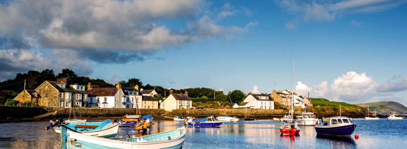
Figure 6.1: Newport
A Portrait of Newport’s Green Infrastructure
6.1 Newport is a small town located on the northern coast of Pembrokeshire, at the mouth of the River Nevern. With 12th century origins, the town contains multiple listed buildings within the Newport and Newport Parrog Conservation Areas. The Newport Conservation Area covers much of the town centre, whereas the Newport Parrog Conservation Area follows the seawall in the north towards Parrog. Situated within a low-lying area in proximity to the sandy river estuary, the town commands north easterly views across Newport Bay. Located within the Pembrokeshire Coast National Park, the town also has strong recreational links to the wider landscape.
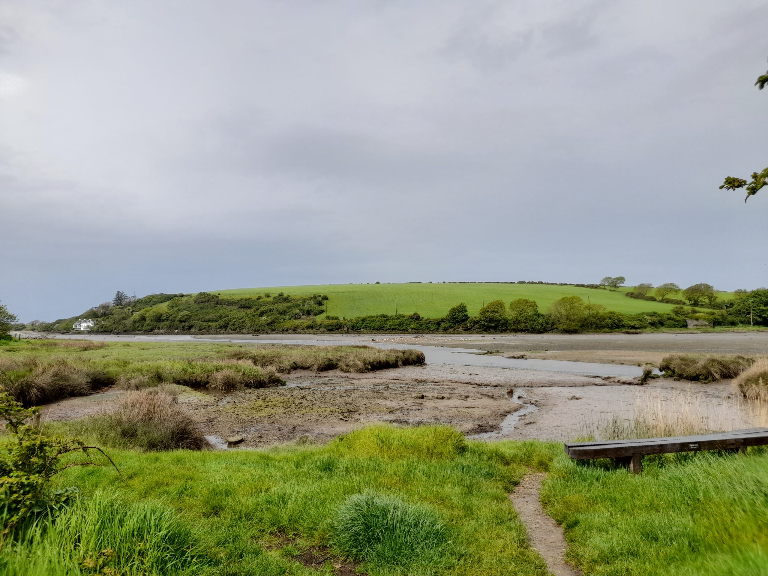
6.2 Although a handful of public open spaces exist within the settlement core, the estuary and coastline to the north offer a significant recreational corridor. This includes a section of the Pembrokeshire Coast Path, a 186-mile National Trail. To the south of the town is a large area of open access land at Carningli Mountain which is located within the Preseli Hills and is popular with walkers. A number of public footpaths link these areas north-south and offer some connections through the town centre and towards the edge of the Nevern Estuary. Additionally, a National Cycle Network (NCN) route 82 connects the Preseli Hills to the eastern edge of Newport before continuing on towards the town of Nevern in the east, offering access to the wider countryside.
Figure 6.2: GI Opportunities within Newport
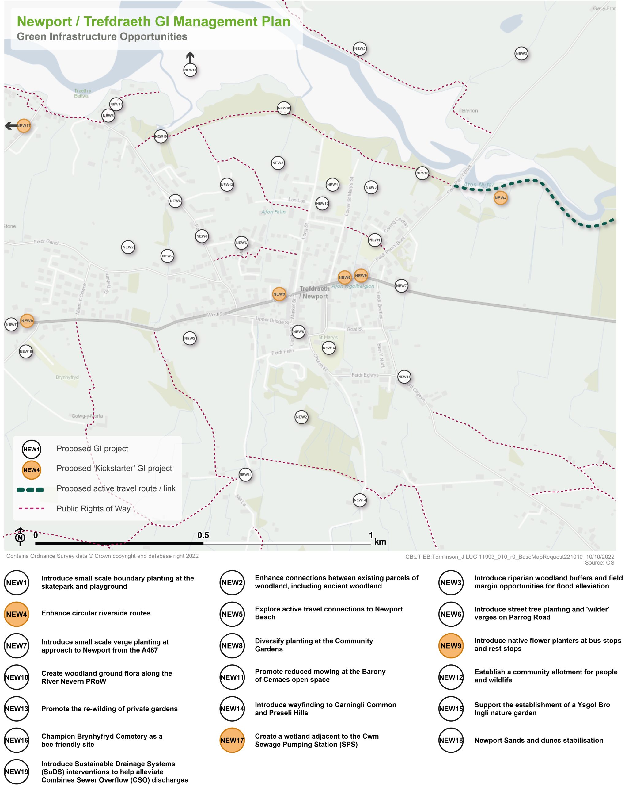
Kickstarter Projects
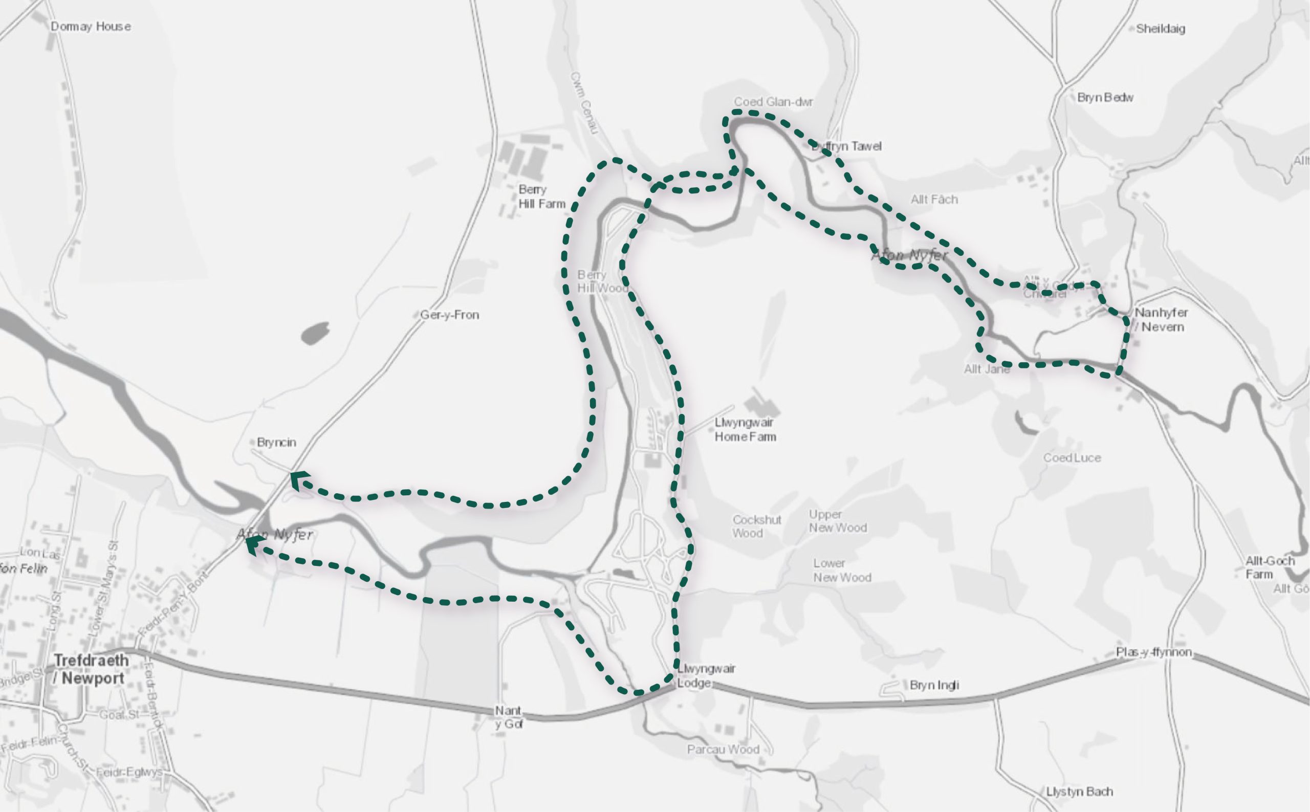
NEW 4 – Enhance circular riverside routes
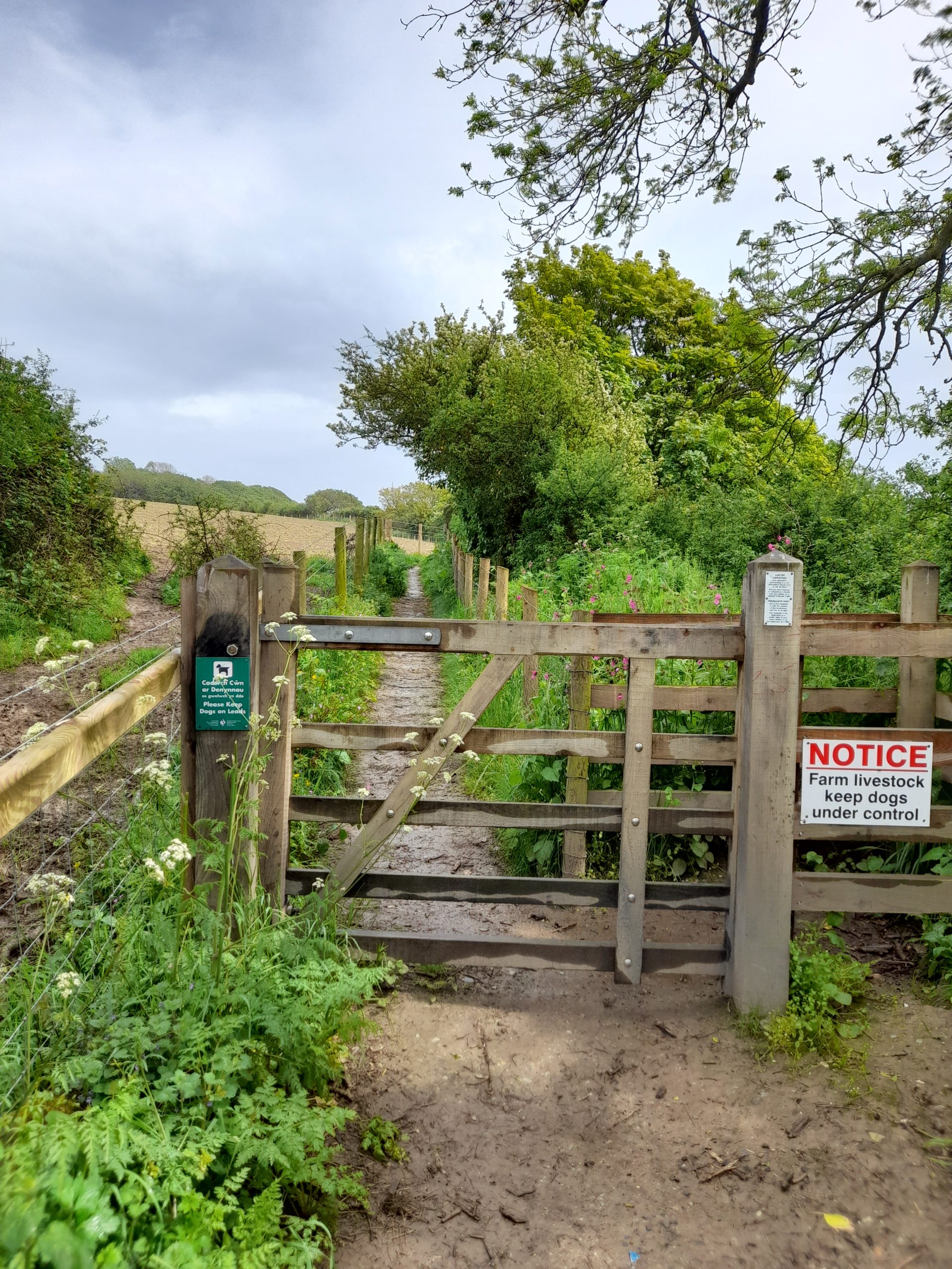
6.3 Building on the recently opened Llwybr Pwll Cornel public footpath which follows the northern edge of the Afon Nyfer, to the east of Pen-y-Bont, the opportunity exists to extend the existing riverside pathway on the southern side of the watercourse. Created in 2021 by the Pembrokeshire Coast National Park Authority (PCNPA), the newly implemented recreational route to the north of the river consists of an unsurfaced informal path characterised by steep gradients in Berry Hill Wood. Through the establishment of linkages with the new Public Right of Way (PRoW) at Pont Newydd, an extension along the southern bank would create a circular walk and promote wider access to the countryside. Connections with the Pilgrims Path would also enhance the recreational opportunities of the Afon Nyfer. The design of the route offers the opportunity to promote accessibility and inclusivity for a range of users, including cyclists, walkers and wheelchair users.
6.4 The establishment of the circular route would enhance the recreational offer at both the local and strategic scale. The potential integration of a range of robust, low maintenance street furniture, interpretation, signage and incidental natural play features along the route would also help to transform the corridor into a recreational asset. However, the scheme would require an assessment of the natural habitat to determine if the introduction of public access is sustainable and should be promoted. Potential conflicts between biodiversity and recreational access opportunities would need to be assessed. Consideration should be given to the introduction of a ‘code of conduct’ for appropriate behaviour on ecologically sensitive sections of the route to help encourage more responsible recreation.
Figure 6.3: NEW4
Benefits of the project
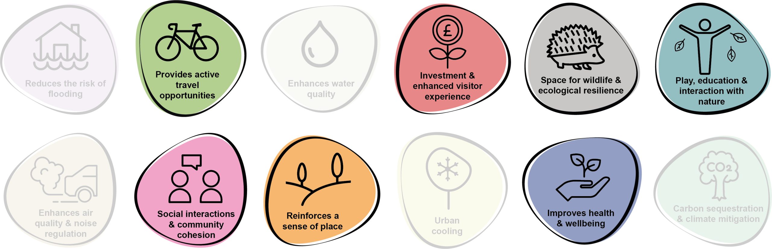
6.5 Benefits of the project, as depicted in Figure 6.4 below, include:
- Provides active travel opportunities
- Investment & enhanced visitor experience
- Space for wildlife and ecological resilience
- Play, education and interaction with nature
- Social interaction and community cohesion
- Reinforces a sense of place
- Improves health and wellbeing
Figure 6.4: Benefits
Delivery mechanisms
6.6 Significant external funding and allocation of staff resource would be required, underpinned by cooperative landowners and a sustainability assessment to determine the appropriateness of introducing public access.
Potential partners
- PCNPA
- Landowners
- Natural Resources Wales (NRW)
Outline cost
High cost = >£1 million
Potential funding opportunities
- Natural Resources Wales
- PCNPA
- Transport for Wales
Timescale
Long-term = >5 years
6.7 Following consultation, landowner engagement, surveys and a collaborative design process, the project will likely take around 5 years to deliver.
Potential constraints
6.8 The project is likely to be complex, with competing demands. This includes the requirement for significant external funding and liaison with local landowners to ensure buy-in on privately owned land. It would be necessary to engage with landowners and land occupiers in order to present these opportunities and discuss their impacts on current land-use. However, a key unknown for the project would be the time needed to gain these landowner consents.
6.9 The project would also require localised vegetation clearance along some sections of the route. This would need to be undertaken to avoid the bird nesting season and in liaison with an ecologist or Ecological Clerk of Works (ECoW).
Maintenance and stewardship
6.10 Ongoing annual maintenance of the hard surfacing of the route would be required to ensure access is maintained throughout the year. Landscape management works would also be required to ensure the retention of sightlines across the route.
Monitoring for success
6.11 The opportunity exists to install sensors or counters to monitor the usage of the route as part of the wider active travel network within the county. This approach would help measure the success of the substantial investment and inform the long-term strategy and delivery of similar projects in the future.
Next steps
6.12 A sustainability assessment would form the initial task in the development of the project. If deemed acceptable following the results of the assessment, a feasibility study and optioneering exercise should then be undertaken. This should also incorporate an ecological assessment and tree survey to BS5837: 2012 to examine the implications on local biodiversity and existing tree cover. Working with the community, opportunities for community-led design workshops should be explored.
Figure 6.5: Newport
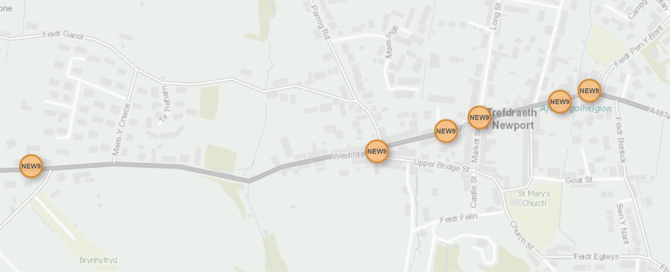
NEW9 – Introduce native flow planters at bus stops and rest stops
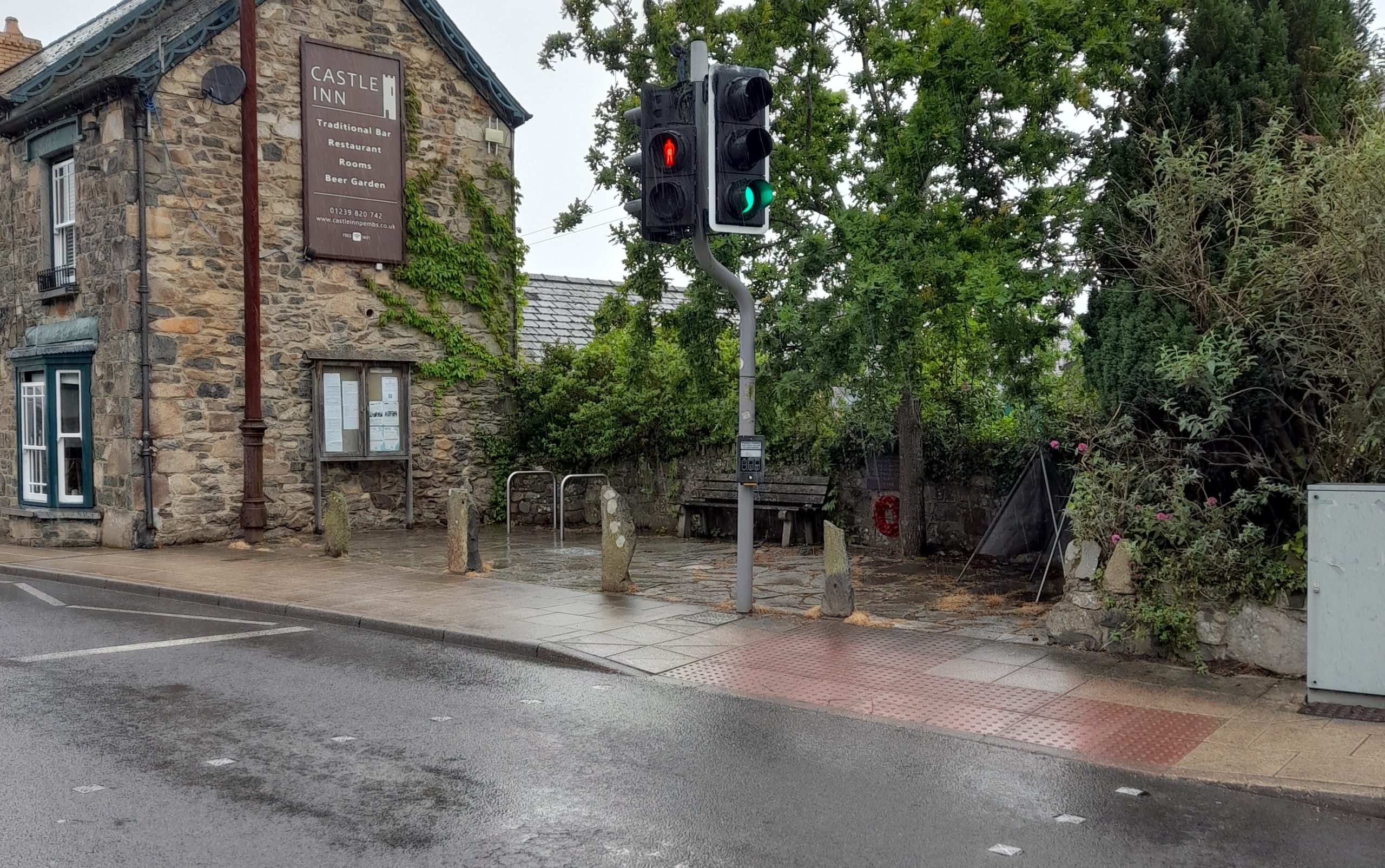
6.13 The urban setting of the town centre provides a barrier for the movement of pollinators from east to west. Opportunities for wildflower verges or more continuous habitat creation are constrained by narrow pavements within the existing street pattern. However, the opportunity exists to introduce planters with native pollinator-friendly shrubs adjacent to bus stops (e.g. at the west of the town, the Castle Inn and the Golden Lion Hotel) and rest stops (e.g. by the bench and cycle racks next to Castle Inn, by Llys Meddyg Hotel, outside the Post Office) to enhance biodiversity value. Local residents and businesses should also be encouraged to install native flower rich window boxes or hanging baskets, which would also increase the visual appeal of their shop fronts or homes.
6.14 Initiatives such as ‘Buzz Stops’ in Cornwall, ‘Bee Stops’ in cities such as Derby and Leicester or ‘Edible Bus Stops’ in Stockwell, London, have all helped create pollinator habitat and increase awareness of the importance of pollinators. Such similar branding in Newport could help achieve buy-in from residents.
6.15 Larger perennial plants should be placed in the centre of planters, with plants of decreasing size further towards the outside, with trailing plants at the edge. If the planter is against a wall, the largest plants should be placed at the back. Where space permits, these could be combined to function as rain gardens to help manage surface water run-off.
Figure 6.6: NEW9
Benefits of the project
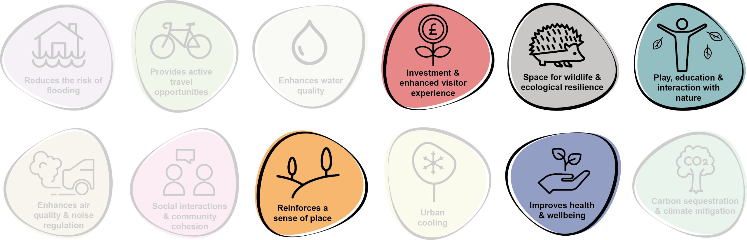
6.16 Benefits of the project, as depicted in Figure 6.7 below, include:
- Investment & enhanced visitor experience
- Space for wildlife and ecological resilience
- Play, education and interaction with nature
- Reinforces a sense of place
- Improves health and wellbeing
Figure 6.7: Benefits
Delivery mechanisms
6.17 Planters and hanging baskets should be delivered in accordance with the delivery section of the Pollinator Strategy. Local businesses may be interested in sponsoring planters outside their shops in return for advertising or promotion.
Potential partners
- Newport Town Council
- Newport Environment Group
- Pembrokeshire Nature Partnership
- Pembrokeshire County Council (PCC) StreetCare / Amenity Maintenance Team
- Local homeowners
- Local businesses
Outline cost
Low cost = <£250k
6.18 Given the constrained space within the town centre, planters are likely to be smaller in size and so relatively inexpensive. The cost for native bulbs or plug plants would be reduced if local businesses were involved in sponsorship.
Potential funding opportunities
- Local Places for Nature Fund; and
- Local business sponsorships
Timescale
Quick win = <1 year
6.19 Interventions can be delivered almost instantaneously following some business and resident engagement.
Potential constraints
6.20 For the planters to successfully establish, maintenance would be required. Without this, they may become visually unappealing and lose community support. As the planters would be located in public locations, they may also be disturbed or damaged by antisocial behaviour.
Maintenance and stewardship
6.21 Throughout the spring and summer, planters should be watered daily. When plants are in flower they may benefit from a high potassium liquid feed fortnightly. Containers or pots should have good drainage to prevent waterlogging. To prevent plants from getting too wet and cold over winter, they should be raised slightly off the ground and placed against the shelter of a wall. Local businesses or homeowners within the closest proximity to the planters could be engaged to assist with this maintenance.
Monitoring for success
6.22 The success of the planters could be recorded by the number of pollinating insects they attract and the diversity of species. The Flower-Insect Timed Counts (FIT Counts) methodology has been developed by the UK Pollinator Monitoring Scheme. This involves counting the insects visiting one of the 14 flower species target flowers within a 50cm by 50cm square patch for 10 minutes in good weather. Local people could partake in this as a citizen science programme.
6.23 Success could also be monitored by recording how many additional planters have been installed by local residents or businesses.
Next steps
6.24 Review the delivery section of the Pollinator Strategy to determine the process and review case studies relating to the installation of planters and hanging baskets.
6.25 Consult with South Wales Trunk Road Agent (SWTRA) and PCC StreetCare / Amenity Maintenance Team.
6.26 Engage with local residents and businesses to establish interest in sponsoring and/or maintaining planters within the town centre.
Figure 6.8: Newport
NEW17 – Create a wetland adjacent to the Cwm Sewage Pumping Station (SPS)
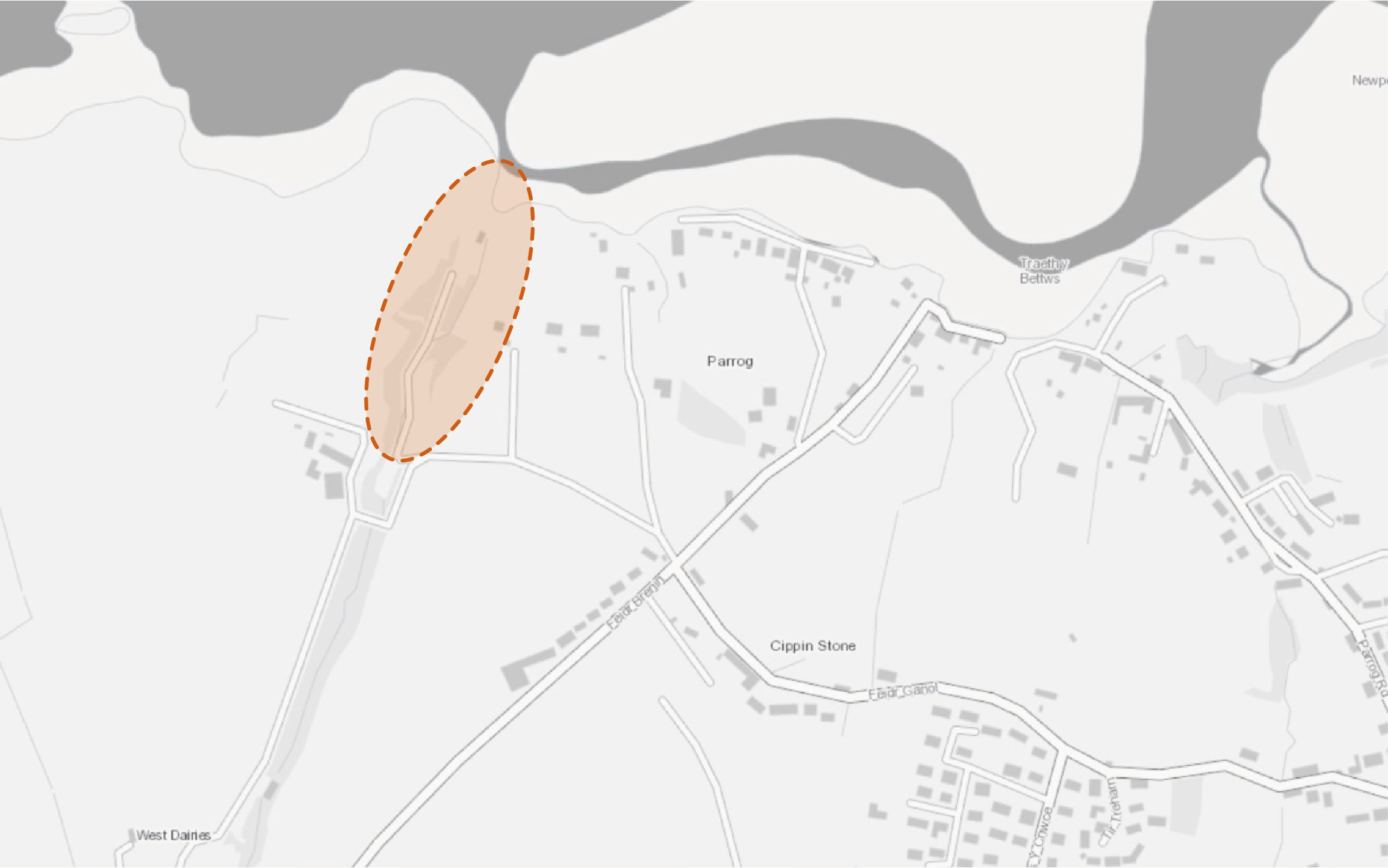
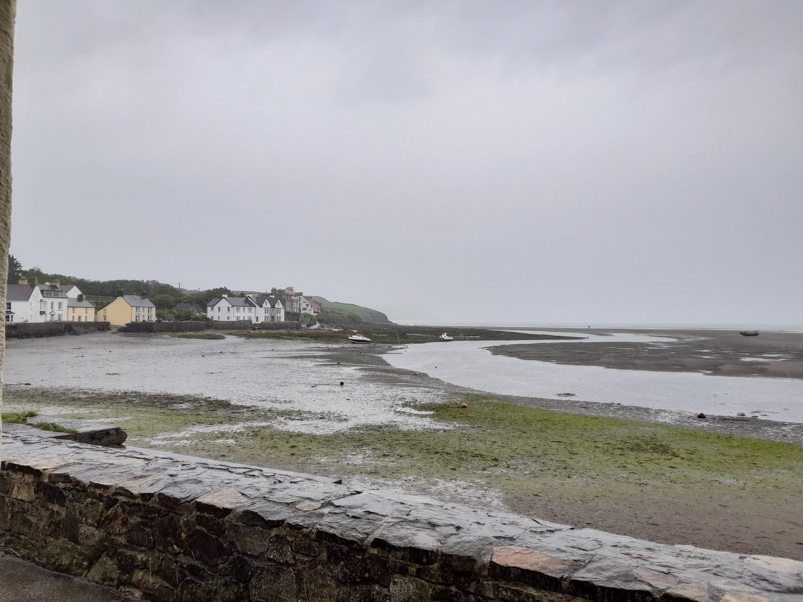
6.27 Newport lies immediately south of the Afon Nyfer Estuary, within the boundary of the Pembrokeshire Coast National Park and in close proximity to the Newport Cliffs Site of Special Scientific Interest (SSSI) and Cardigan Bay Special Area of Conservation (SAC). The town currently utilises a long sea outfall located at the Parrog to discharge excess sewer and storm outflows.
6.28 Cwm Sewage Pumping Station (SPS) located to the north west acts as a terminal station receiving all the combined flows from the Newport catchment. Currently flows of 14l/s are transported to Newport’s Waste Water Treatment Works 800m to the south. This treated effluent is then returned and discharged via the long sea outfall. Whilst this system is operational most of the time, in periods of excess flow combined storm overflow events occur, where untreated effluent bypasses treatment and flows directly into the sea outfall. In 2021, 2,423.25 total hours of such overflows occurred at the Cwm Sewage Pumping Station.
6.29 Conversion of farmland adjacent to the Dwr Cymru Welsh Water infrastructure into wetland habitat would provide a secondary treatment for treated effluent, and also a buffer for storm flows before they discharge to the sea outfall. The proposed location of this would need careful consideration, including comprehensive stakeholder and community consultation.
6.30 The potential also exists to work in conjunction with the CLEAN Afon Nyfer project to incorporate citizen science monitoring of the wetlands to examine its impact on the effluent outfall and associated water quality.
Figure 6.9: NEW17
Benefits of the project
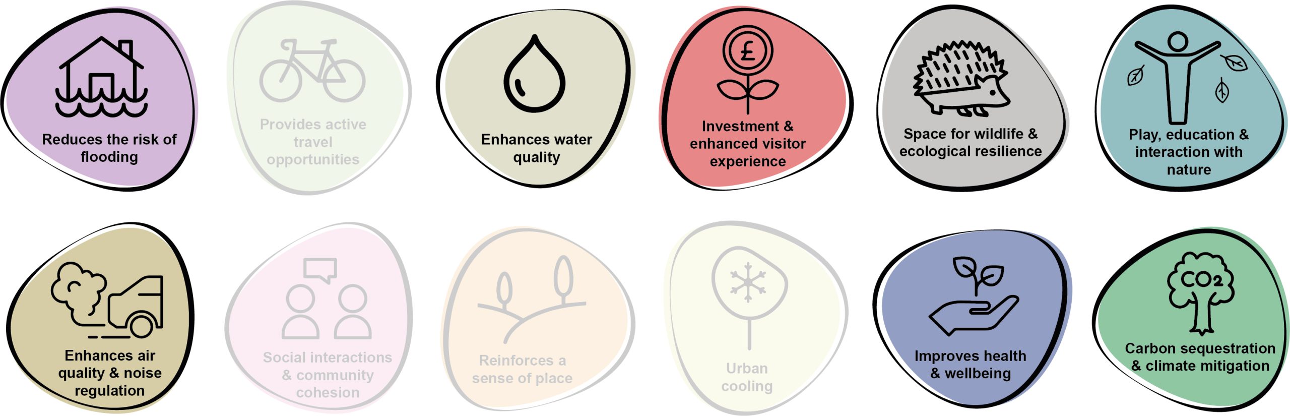
6.31 Benefits of the project, as depicted in Figure 6.10 below, include:
- Reduces the risk of flooding
- Enhances water quality
- Investment & enhanced visitor experience
- Space for wildlife and ecological resilience
- Play, education and interaction with nature
- Enhances air quality & noise regulation
- Improves health and wellbeing
- Carbon sequestration & climate mitigation
Figure 6.10: Benefits
Delivery of nature-based solutions and ecosystem services
6.32 Wetlands can aid flood alleviation, acting as a store of excess water in periods of heavy rainfall in addition to their primary function of nutrient stripping and cycling. These habitats also provide multiple biodiversity benefits.
6.33 Constructed wetlands, if designed correctly, can achieve sustainable effluent treatment that provides a reduction in contaminant concentration similar to more complex chemical-based or mechanical mechanisms. The effluent from sewage treatment facilities is typically rich in nutrients and wetlands can be used to help alleviate this issue in a sensitive areas such as the Afon Nyfer Estuary and Cardigan Bay SAC
Delivery mechanisms
6.34 The cooperation and involvement of Dwr Cymru Welsh Water would be critical to the success of this project, and hence the first stage would be to engage with them and to draw together a feasibility study, looking at the required throughflow rates, the space available and the options associated with wetland design.
6.35 An appropriate design engineer should be consulted to provide a design of the wetlands. The potential area for the wetlands should be calculated and agreed with relevant landowners. Consultation with the local community should be undertaken to enable engagement with the plans. Contractors required to scope out the topography and excavate selected areas should be employed. Consideration of materials needed to create the wetlands such as substrate materials and vegetation should also be sourced as locally as possible.
6.36 The potential exists that this project could be used to create nutrient trading credits as a mechanism to wholly or partially fund the project, with a pilot scheme run by EEP-Ecobank for nutrient credits operating within the Milford Haven catchment although the status of this project is currently unclear.
6.37 Citizen science and combined storm overflow monitoring should be utilised to help inform and monitor the project. Although scientific studies are outside the scope of this phase of works, any information obtained by citizen science relating to the health of the local marine environment would also be welcomed to support this project. An ecological assessment of potential sites should be undertaken prior to selection.
Potential partners
- Afon Nyfer CLEAN
- Wildlife Trust of South & West Wales
- Dwr Cymru Welsh Water
- Natural Resources Wales (NRW)
- Pembrokeshire Coastal Forum
- Cardigan Bay Marine Wildlife Group
Outline cost
Low to medium cost = <£250k – £1 million
6.38 Costs would comprise land purchase or rent, specialist engineer design of the wetlands, procurement of planting and costs associated with excavation and installation of the wetlands.
Potential funding opportunities
- Dwr Cymru Welsh Water
- The Four Rivers for LIFE project
- Nutrient credits using Section 106 agreement
- National Lottery Community Fund
- Ofwat Innovation Fund
Timescale
Medium-term = 1-5 years
6.39 This anticipated programme length includes for time to enable design of the wetland, agreements with landowners, construction and planting of the wetland.
Potential constraints
6.40 A key constraint for the project would be securing landowner agreements. It would also be essential to ensure the wetlands are located adjacent to the sewage treatment infrastructure to avoid re-routing sewage outfalls that would increase time and costs of the project. Antibiotic-resistant bacteria accumulation in wetlands is a concern and should be considered in the design of the wetlands.
6.41 An ecological assessment of the site would need to be undertaken by an ecologist with all site works potentially supervised by an Ecological Clerk of Works (ECoW).
Maintenance and stewardship
6.42 Wetlands are fairly low maintenance with little to no running costs as they do not require power and are generally reliable self-adjusting systems. However, maintenance would be required a few times a year to remove debris from any outlets, replace any damaged pipes, remove any invasive plant species that may be outcompeting the wetland plants, reduce sediment accumulation and check the structural integrity of the structural aspects of the design. Ongoing agreements with Dwr Cymru Welsh Water or landholders for access would be crucial.
Monitoring for success
6.43 Subject to availability of funding, monitoring of the success of the project should be undertaken through simple citizen science. Techniques could include monitoring of water quality using simple hand-held equipment.
Next steps
6.44 Dwr Cymru Welsh Water’s collaboration would be critical to ensure the success of this project, and so the first step would be to enter into discussion with Dwr Cymru Welsh Water and sign up to a collaboration agreement. This may also enable access to funding for the project, either with Dwr Cymru Welsh Water or as part of the Ofwat Innovation Fund.
6.45 Engage with landowners to enter into agreements to purchase or rent their land. Engage with the local community to create support and ’buy-in’ for the project.
Figure 6.11: Newport
Project Long List
NEW1 – Introduce small scale boundary planting at the skatepark and playground
6.46 The opportunity exists for tree planting along the boundaries of the skate park, playing field, playground and the areas between the tennis courts and playing field. This would include the planting of small fruit trees. Any planting should aim to maintain good sightlines across the site to maintain a sense of safety and natural surveillance. Any new planting should also consider local constraints, including the proximity to the Scheduled Monument.
NEW2 – Enhance connections between existing parcels of woodland, including ancient woodland
6.47 There are several parcels of woodland directly to the south and west of the settlement, including areas of tree cover adjacent to Newport Castle. Proposals should be developed to restore and connect areas of fragmented woodland through the establishment of additional areas of tree planting. Proposals should adopt ‘right tree in the right place’ principles to promote landscape integration and ensure the successful establishment of new woodland corridors.
NEW3 – Introduce riparian woodland buffers and field margin opportunities for flood alleviation
6.48 Whilst the majority of the town lies out of the flood zone surrounding the Afon Nyfer, flood events in 2014 affected roads and properties near to the Parrog. Measures such as upstream tree planting and increasing field margins should be located along watercourses to provide a buffer from adjacent agricultural land, as well as protecting from tidal surges and reducing bank erosion. This issue is of particular importance to the north of the estuary where agricultural field boundaries are less heavily vegetated. The project has the potential to respond to a number of potential harmful issues affecting marine life, including sediment and nutrient loads entering the environment. Further information could be used to modify the project to target potential areas of concern.
NEW4 – Enhance circular riverside routes
6.49 Refer to Kickstarter Projects.
NEW5 – Explore active travel connections to Newport Beach
6.50 At present, a walking route between Newport and Newport Beach is available along the Wales Coast Path. The opportunity exists to upgrade this route to the north of the River Nevern to accommodate walkers to encourage its use and reduce traffic congestion within Newport. Wayfinding signage which advertises approximate travel times to walk, for example, 30 minute walk between Newport Boat Club and Newport Beach, should also be installed.
NEW6 – Introduce street tree planting and ‘wilder’ verges on Parrog Road
6.51 Streets within Newport are generally narrow, often with little pavement space and constrained street tree planting opportunities. However, some residential areas along Parrog Road and Maeslingi Road provide good opportunities for street tree planting, installation of cycle parking and ‘wilder’ verges within existing soft landscape areas. Additional boundary planting at the Parrog Road Public Car Park would include planting in grass areas, as well as minor parking bay reconfiguration to allow for hardstanding removal.
NEW7 – Introduce small scale verge planting at approach to Newport from the A487
6.52 The A487 forms the primary route within the town, with active travel routes proposed along both the eastern and western approaches. Tree planting and modifications to the mowing regime to promote the growth of wildflowers should be considered on the wider areas of roadside verge on the approach into Newport from the west and east (beyond the ‘Welcome to Newport’ signs). This intervention would define the gateway to the settlement.
NEW8 – Diversify planting at the Community Gardens
6.53 The Newport Community Gardens at the intersection of Church Street and Castle Street provides a rare ‘wilder’ area in the centre of the town. Replacement of ornamental plants in the lower paved area with native flowers and shrubs would provide increased value to pollinators. The mowing of the upper grassy area with the bench should be relaxed and wildflowers sown to create a range of pollinator habitats. The use of pesticides or herbicides should be avoided.
NEW9 – Introduce native flower planters at bus stops and rest stops
6.54 Refer to Kickstarter Projects.
NEW10 – Create woodland ground flora along the River Nevern PRoW
6.55 Working in conjunction with the Newport Paths Group and the CLEAN project, introduce improvements to woodland management along the Wales Coast Path between Pen-y-Bont and Parrog. Maintain open areas and structural diversity, including bare ground and log piles, to allow light to reach native wildflowers and woodland ground flora. Opportunities to control and remove Japanese knotweed and skunk cabbage should be explored.
NEW11 – Promote reduced mowing at the Barony of Cemaes open space
6.56 The area of open space owned by the Barony of Cemaes next to the Newport Boat Club is frequently closely mown. Changes in landscape management practices to promote the establishment of wildflower meadow would maintain the function as a community space, whilst providing much needed habitat for pollinators. Similar meadow management regimes should be rolled out across other amenity grass areas within the town (as appropriate).
NEW12 – Establish a community allotment for people and wildlife
6.57 Work with the community to consider a potential location for a community allotment, meeting the demand for a community growing space. Successful delivery of this project would be dependent on locating a suitable site and undertaking an ecological assessment. Plot tenants should be encouraged to reduce the use of pesticides and herbicides, instead choosing to work organically. Maintaining an allotment provides a valuable opportunity to preserve wildlife habitats and encourage birds, bees and other pollinators. Additional opportunities for ponds, pollinator-friendly field margins and orchard trees should also be explored.
NEW13 – Promote the re-wilding of private gardens
6.58 Develop a wild web initiative across Newport’s private gardens with a particular focus on second home owners to demonstrate how re-wilding can reduce maintenance. Leaflets should be distributed to homes in Newport setting out simple steps occupiers can take to enhance wildlife provisions in their garden. For instance, residents should be encouraged to relax mowing regimes and participate in ‘No Mow May’, install small areas of water, log piles and wildlife boxes. The initiative should also be extended to caravan sites (as appropriate).
NEW14 – Introduce wayfinding to Carningli Common and Preseli Hills
6.59 Work in partnership with the Newport Paths Group, investigate proposals to enhance wayfinding to the wider countryside surrounding Newport (including to Carningli Common and Preseli Hills). Interpretation boards, including educational material and circular recreational route maps, should be incorporated to enhance the visitor experience.
NEW15 – Support the establishment of a Ysgol Bro Ingli nature garden
6.60 Work with Ysgol Bro Ingli to identify areas of land for habitat enhancements; including areas of reduced mowing, log piles and insect hotels. Should sufficient space be identified, a sensory nature garden should be introduced with opportunities for outdoor classroom space, nature education equipment, small-scale food growth and sensory play.
NEW16 – Champion Brynhyfryd Cemetery as a bee-friendly site
6.61 Brynhyfryd Cemetery is currently recognised as a Bee Friendly location due to the work of partners in managing the surrounding setting for pollinators. This work should be supported in order to help maintain this accreditation by managing wildflower meadows and increasing pollinator habitat (such as bare earth and dead wood). Opportunities to replicate this good practice within St Mary’s Churchyard should also be explored.
NEW17 – Create a wetland adjacent to the Cwm Sewage Pumping Station (SPS)
6.62 Refer to Kickstarter Projects.
NEW18 – Newport Sands and dunes stabilisation
6.63 Newport Sands and the associated dunes current shoreline management plan until 2025 promotes the principle of ‘holding the line’ with a ‘managed realignment’ planned by 2050 with the expected erosion of the Bennet sand spit. The opportunity exists to include sand dune stabilisation techniques, such as the planting of semi-natural species to limit erosion and managing walkways to prevent dune erosion. This approach has the potential to benefit wildlife, provide tourism benefits and reduce impacts from adverse weather events on the local environment.
NEW19 – Introduce Sustainable Drainage Systems (SuDS) interventions to help alleviate Combines Sewer Overflow (CSO) discharges
6.64 Sustainable Drainage Systems (SuDS) interventions which act to divert storm water from Combined Sewer Overflows (CSOs) would help to reduce pressure on infrastructure within Newport in times of flooding. The integration of SuDS interventions would help to reduce the volume of surface water which is directly channelled through a networks of pipes. The potential also exists to work in conjunction with Newport Town Council to explore locations for SuDS interventions within the townscape.
Previous Chapter:
Narberth
Next Chapter
Neyland
Return to homepage:
Homepage