Archaeological survey takes to the skies over North Pembrokeshire
Skywatchers in North Pembrokeshire might spot an unusual aircraft circling Pembrokeshire airspace later on this month as an aerial archaeology survey gets underway.
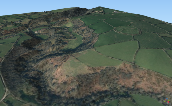
The survey involves high resolution aerial photography and Lidar data being captured from a small plane and is part of the ‘Dawnsio ar y Dibyn’ Sustainable Management Scheme, funded by the Welsh Government through the European Regional Development Fund.
This will be used to build topographical models of the landscape and potentially reveal new archaeological information. The survey will be focussed on the northern section of the National Park and the area around Strumble Head.
The captured data will be analysed to identify known and unknown archaeological features in the landscape. This will be done using the help of archaeologists and volunteers, who will look at the data digitally and then carry out field surveys to verify what has been identified.
Tomos Ll. Jones, Community Archaeologist for the Pembrokeshire Coast National Park Authority, said:
“This is an exciting opportunity to discover more about the Pembrokeshire landscape and its long history of human habitation.
“The historic environment is part of what makes the Pembrokeshire Coast National Park such a special place. People have lived and worked in the Park for thousands of years, and have shaped the way it looks today.
“Lidar and aerial photography can be used to make impressive visualisations of the landscape. We hope that by providing training for volunteers, both digitally and out in the field, analysis of the data will continue for a long time to come, further increasing our knowledge of archaeology and heritage in this unique landscape.”
To keep up to date with this survey and to learn about opportunities to get involved, sign up by visiting the National Park Archaeology mailing list page.
More information about Lidar can be found by visiting the English Heritage website.