
Page Contents:
A Portrait of Tenby’s Green Infrastructure
Kickstarter Projects
Project Long List
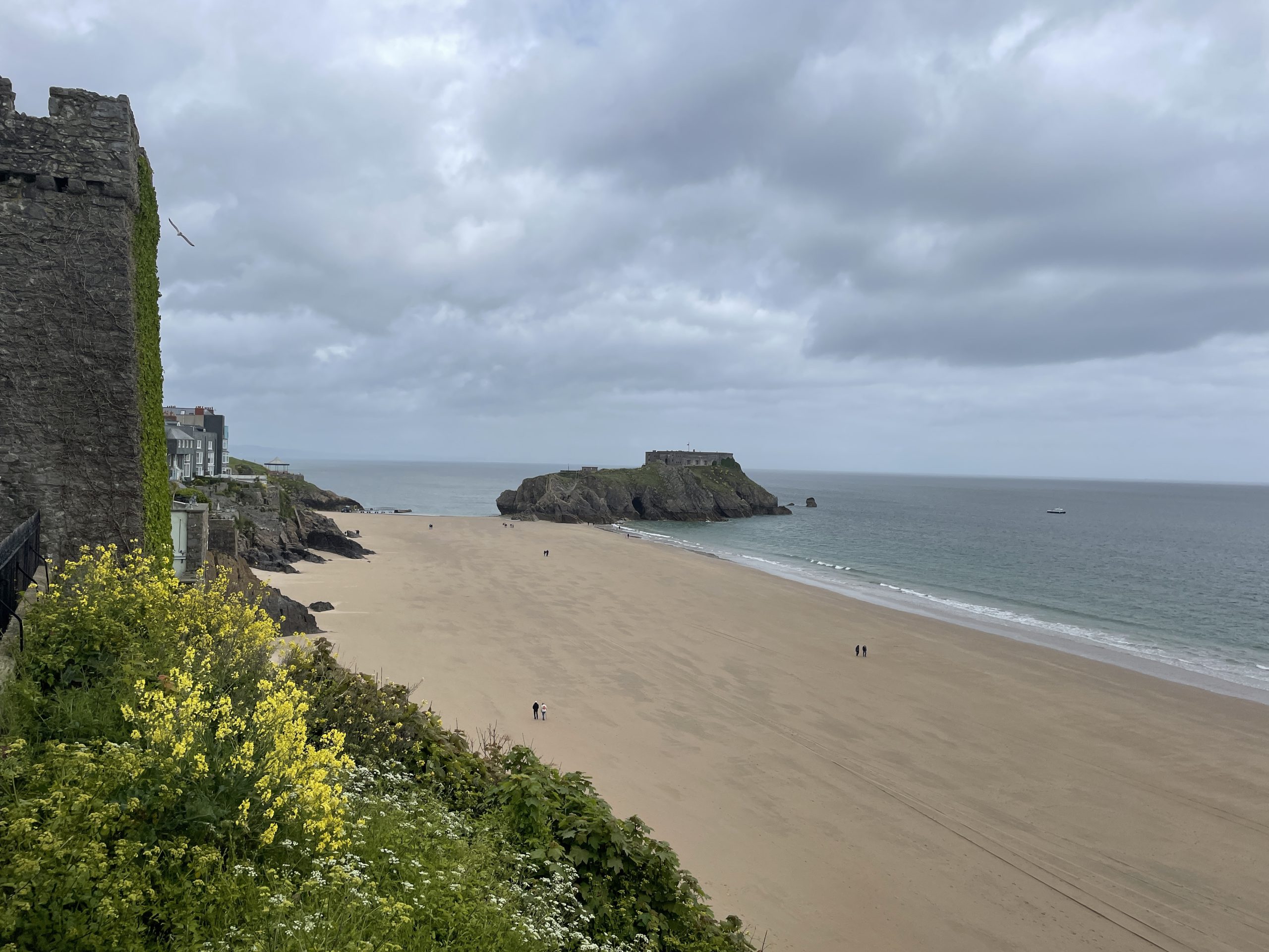
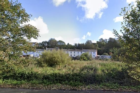
Tenby
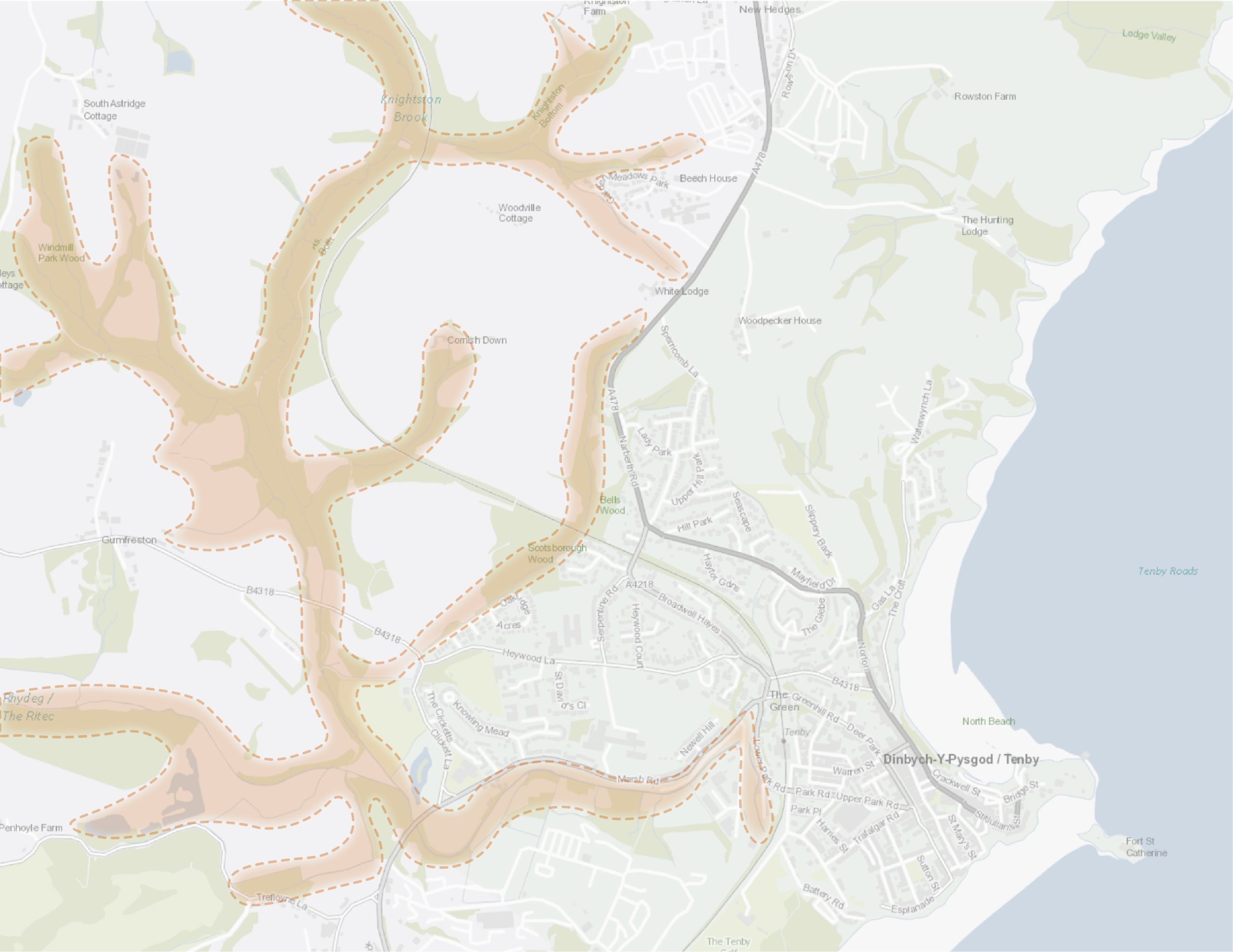
Figure 12.1: Tenby
A Portrait of Tenby’s Green Infrastructure
12.1 Tenby is a medieval walled town on the south Pembrokeshire coast. Built along the clifftop and surrounded by sandy beaches, the town is a popular tourist destination. The ancient Tenby Town Walls encircle the historic core which are designated as a Conservation Area. The historic core’s narrow streets, interlinking alleyways and numerous listed buildings help the town to retain a distinctly maritime character. The 12th century Tenby Castle and the 19th century fort-topped St Catherine’s Island provide distinct elements in Tenby’s seascape character. Tenby is located within the Pembrokeshire Coast National Park.
12.2 Although much of the town’s coastline is urbanised, Tenby is home to multiple public beaches that border the town to the north and south. This popular stretch of coastline is also home to the Pembrokeshire Coast Path National Trail which connects Tenby with the wider Pembrokeshire Coast National Park landscape. Generally, other public open spaces within Tenby are located to the west of the town centre, with green space in the densely settled historic core largely being limited to St Mary’s churchyard. South-west of the town centre, the Ritec River and its broad low-lying floodplain flow in an easterly direction toward the sea. This marshy waterway offers additional areas of recreation opportunity due to a number of public rights of way (PRoW). Belts of ancient woodland and Ritec Fen, which is designated as a Site of Special Scientific Interest (SSSI), make this valley an important wildlife corridor. Tenby’s marine environment is internationally and nationally recognised through its designation under the Bristol Channel Approaches Special Area of Conservation (SAC), Carmarthen Bay and Estuaries SAC, Carmarthen Bay Special Protection Area (SPA), Tenby Cliffs and St Catherine’s Island SSSI, and Lydstep Head to Tenby Burrows SSSI. Overall, tree cover within the settlement core is limited, with much of the woodland located at the town edges, or along the railway and river corridors.
12.3 Tenby has strong transport and recreation links to the wider region through its rail station, promoted walking routes and cycle links. Footpath links connect Tenby with the wider countryside in the north, south and west, as well as the Pembrokeshire Coast Path. National Cycle Network (NCN) 4 also passes through the town and makes use of off-road lanes and coastal paths to the north and south.
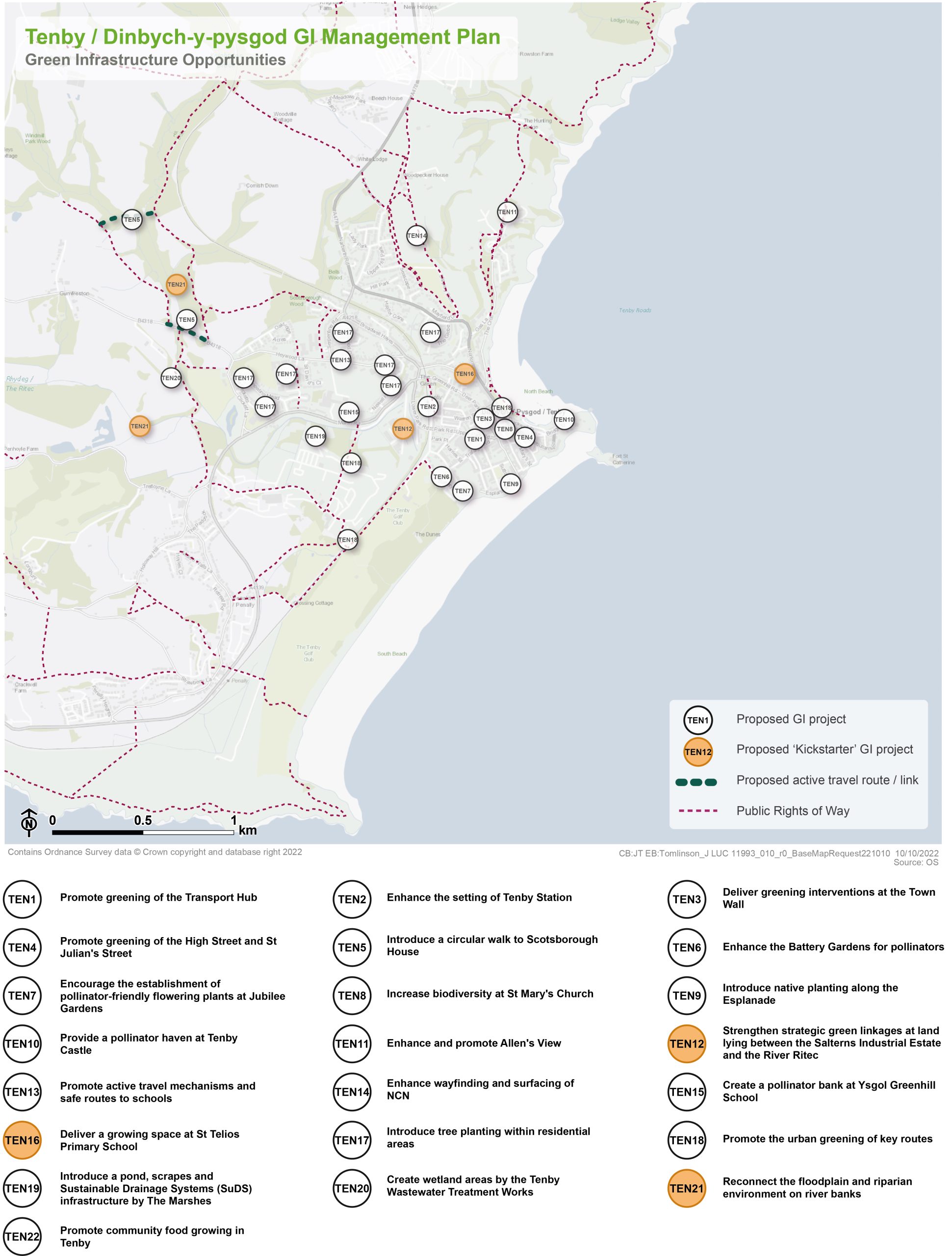
Figure 12.2: GI Opportunities within Tenby
Kickstarter Projects
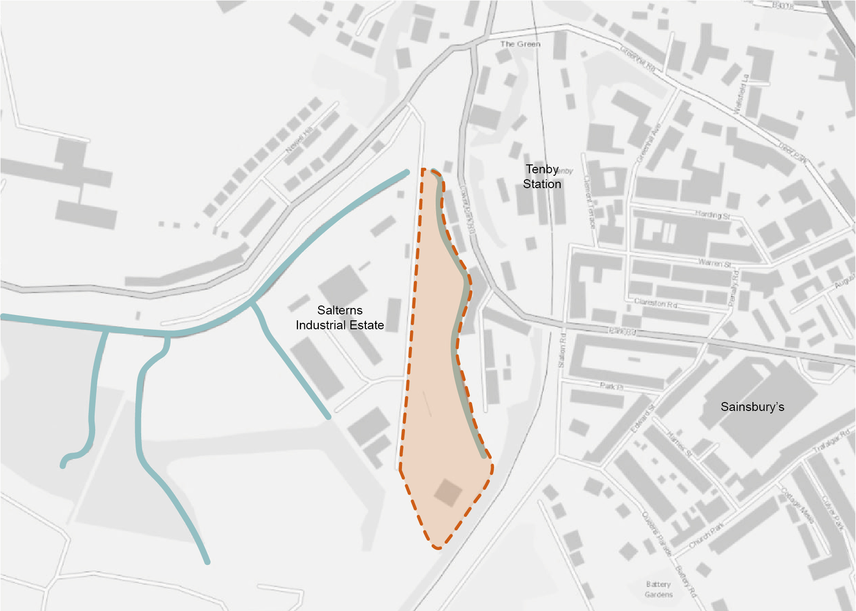
TEN12 – Strengthen strategic green linkages at land lying between the Salterns Industrial Estate and the River Ritec
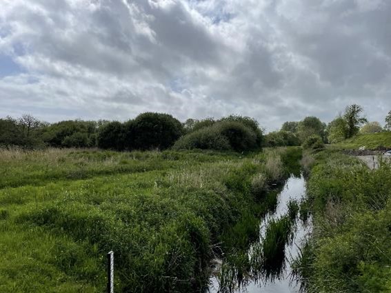
12.4 Land lying between The Salterns and Lower Park Road / Quarry Road currently hosts a mosaic of wet grassland, tree and marshland habitat. The land, which is owned by Pembrokeshire County Council (PCC), is bounded by the River Ritec to the east and forms an important north to south connection between the wooded railway corridor, Tenby Golf Club and woodland at the dunes, with strategic areas of greenspace around Ysgol Greenhill School, Marsh Road and Heywood Lane. At present, the space is largely unmanaged and offers the potential to create a more diverse mosaic of riparian habitat. Opportunities for sensitive access to the riverside to support local interactions with nature, informal paths and naturalistic play features could also be explored. Habitat features, such as log piles and invertebrate houses, should also be introduced to provide additional opportunities for nature exploration.
12.5 The site sits within an area of high flood risk, with the green space, surrounding industrial units at Salterns Industrial Estate and some adjacent housing falling within Flood Zone 3. The creation of additional wetland scrapes, appropriate tree planting and the use of natural flood storage areas should be considered as a nature-based solution to flooding. The strategic location of the space means it could be delivered in partnership with surrounding businesses, residents and schools. Furthermore, the space provides an opportunity to enhance a key active travel link between the town centre and train station. Clear sightlines should be retained into and out of the space for informal surveillance, as well as from adjoining properties.
Figure 12,3: TEN12
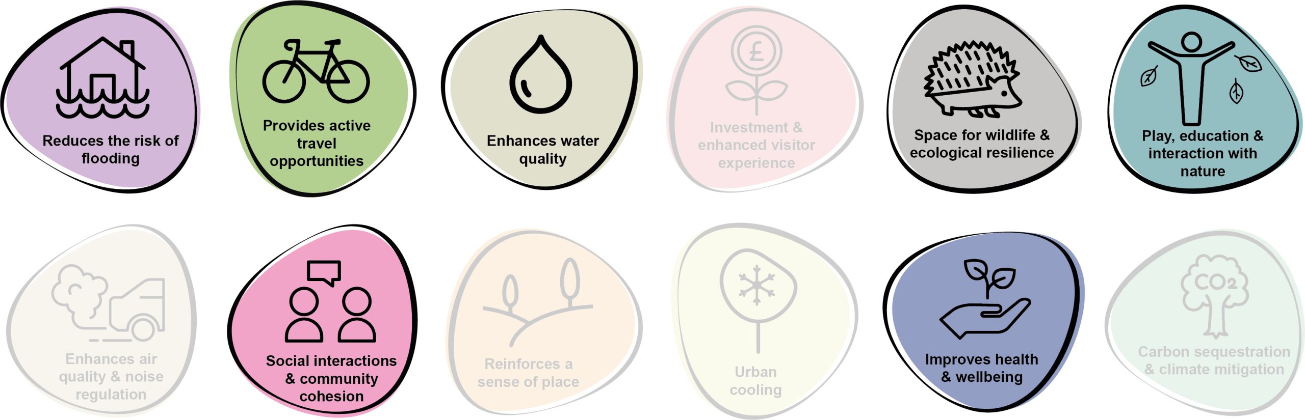
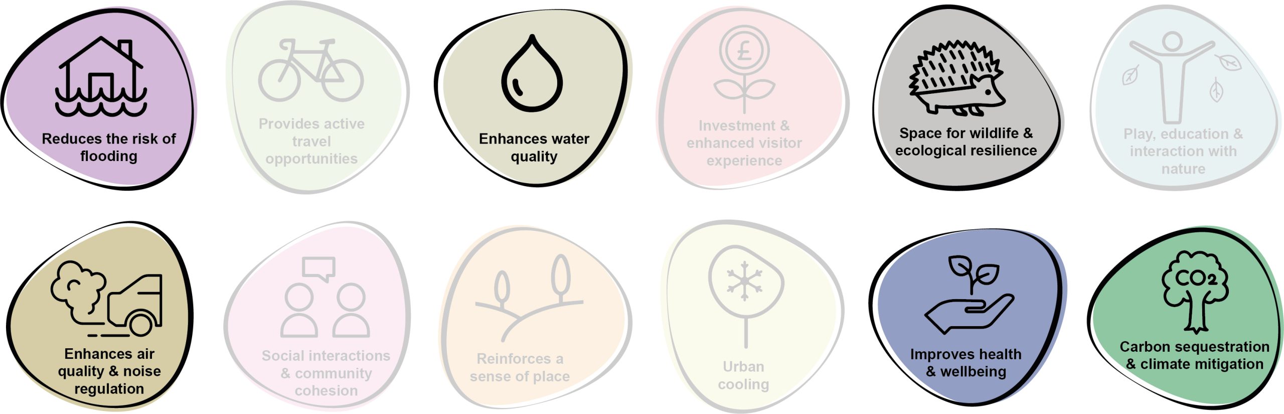
Benefits of the project
12.6 Benefits of the project, as depicted in Figure 12.4 below, include:
- Reduces the risk of flooding
- Provides active travel opportunities
- Enhances water quality
- Space for wildlife and ecological resilience
- Play, education and interaction with nature
- Social interaction and community cohesion
- Improves health and wellbeing
Figure 12.4: Benefits
Delivery mechanisms
12.7 Significant initial effort is required to get the space into a state of positive management, most likely in collaboration with the PCC StreetCare / Amenity Maintenance Team, community groups or other conservation groups such as The Wildlife Trust. Ongoing management of the site should then be incorporated into annual maintenance programmes.
12.8 When planting new trees, ongoing care and management should be delivered for the 60 month establishment phase after planting to ensure their successful independence within the landscape. This should include watering during dry seasons, loosening tree stakes and regular checking for wind throw.
12.9 Part of the scheme, for example tree planting and any wildlife or bulb areas, could be delivered through the Growing Urban Greenspaces 2022 – 2023 programme.
Potential partners
- PCC StreetCare / Amenity Maintenance Team
- The Wildlife Trust of South and West Wales
- Pembrokeshire Nature Partnership
- Tree wardens Pembrokeshire
- Tenby Town Council
- Tenby Green Space Preservation Society
- Local schools
- Local businesses
Outline cost
Low cost = <£250k
12.10 Depending on the degree of community involvement in initial management pushes and ongoing maintenance, the project would be relatively cost effective long-term. The introduction of informal paths, seating and natural play features would present a capital cost if these were pursued.
Potential funding opportunities
- Local Places for Nature Fund
- National Lottery Community Fund
- Nature Networks Fund
- Growing Urban Greenspaces 2022 – 2023 programme
Timescale
Quick win = <1 year
12.11 Initial efforts to get the green space into a state of positive management could be delivered relatively rapidly. However, the continued positive management of the space would be required for its lifetime.
Potential constraints
12.12 The location of the site and the limited degree of natural surveillance presents the risk of antisocial behaviour. By opening up sightlines and views across the River Ritec from neighbouring properties, this may be reduced.
12.13 Ongoing maintenance of the space to ensure the habitat mosaic is retained would require ongoing resource inputs each year. This may be difficult for the PCC StreetCare / Amenity Maintenance Team to incorporate into their management programme without additional support from volunteers.
12.14 Perceptions of ‘wild’ spaces can be that they’re untidy or messy. Signage to communicate the importance of leaving spaces to nature can be used to increase education and understanding.
Maintenance and stewardship
12.15 Ongoing annual maintenance of the space would be needed throughout different seasons. Any new tree planting would need regular care for the 60 month establishment phase following planting. This should include watering during the drier summer months, loosening stakes as they grow, checking the trees and guards for damage following strong winds.
12.16 Regular control and cut back of invasive and dominant species would be required, for example brambles and Himalayan balsam. This can be quite labour intensive but could be picked up by volunteer teams.
12.17 Use of fertilisers, pesticides and insecticides should be avoided, particularly in proximity to the watercourse.
Monitoring for success
12.18 A Citizen Science scheme could be used to monitor the success of the new wildlife space, for example, through invertebrate counting days or monitoring water quality of the River Ritec.
Next steps
12.19 Undertake a Phase 1 habitat / ecological survey of the existing habitat at the space.
12.20 Liaise with the PCC StreetCare / Amenity Maintenance Team to discuss management options and the degree to which community or conservation group support would be needed.
Figure 12.5: Tenby
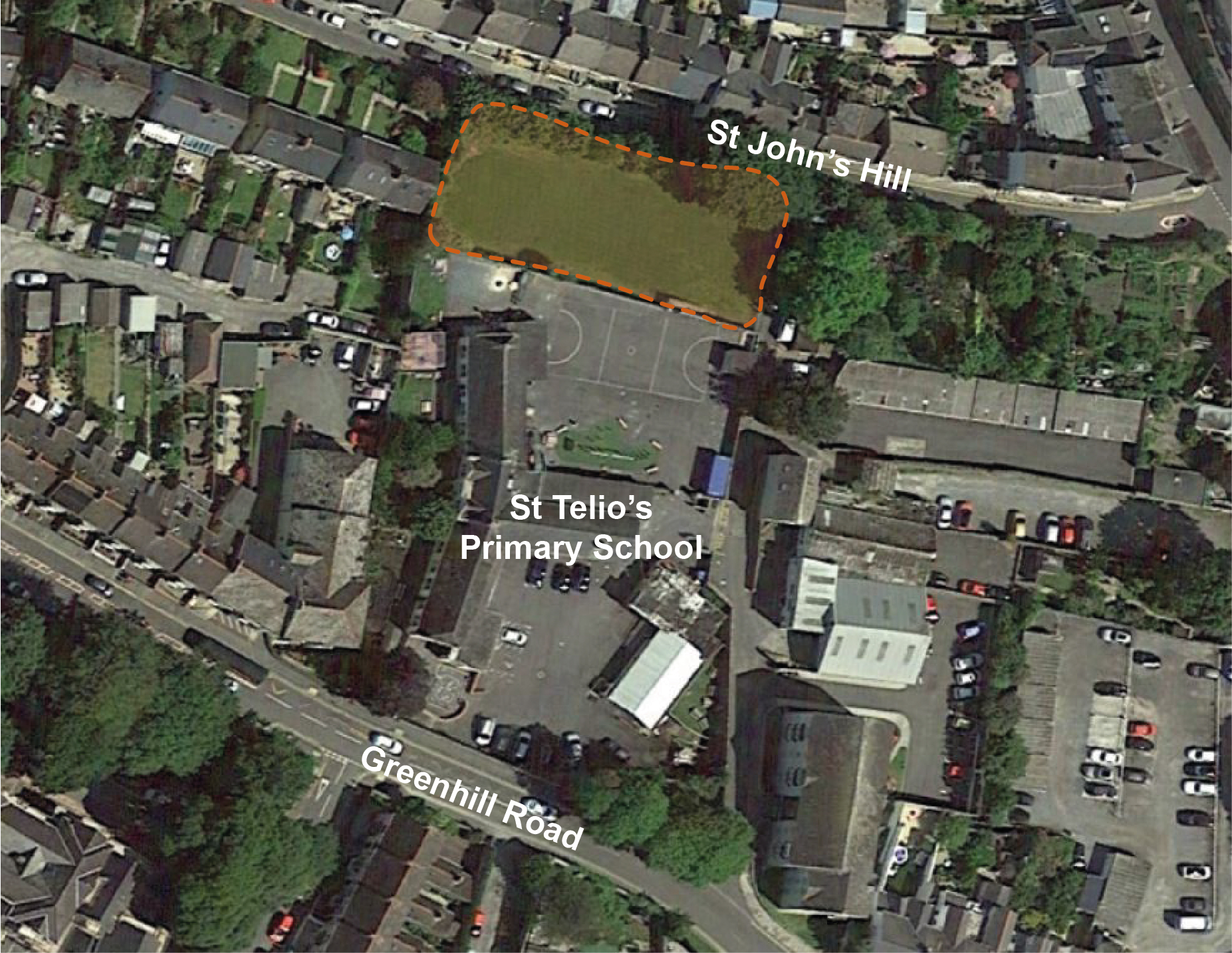
TEN16 – Deliver a growing space at St Telio’s Primary School
12.21 Work with St Telio’s RC Primary School to provide a community orchard and growing space in the area of amenity grass to the north of the school at St. John’s Hill. The introduction of orchard trees within the space would support pollinators and other wildlife, whilst also providing direct ‘tree to plate’ sources of fruit. Blossoms during the spring and shade during the summer would also help to create a more playful and functional space. Vegetable beds, raised containers, planters and vertical climbers offer the opportunity to provide a diverse selection of fruits and vegetables for year-round growing and consumption.
12.22 Additional habitat features such as bug hotels, log piles, bird boxes and areas of meadow establishment would provide additional opportunities for ecological education and interactions with nature. The establishment of the growing facility also offers the potential to work in partnership with the school to integrate sustainable food growth as part of the cirriculum. Working in accordance with the objectives of the Pollinator Strategy for the town, the role spaces these spaces can play in providing wildlife refuge through habitat creation and ecological management practices should also be explored, whilst ensuring sufficient space is retained for outdoor learning and play space.
Figure 12.6: TEN16
Benefits of the project
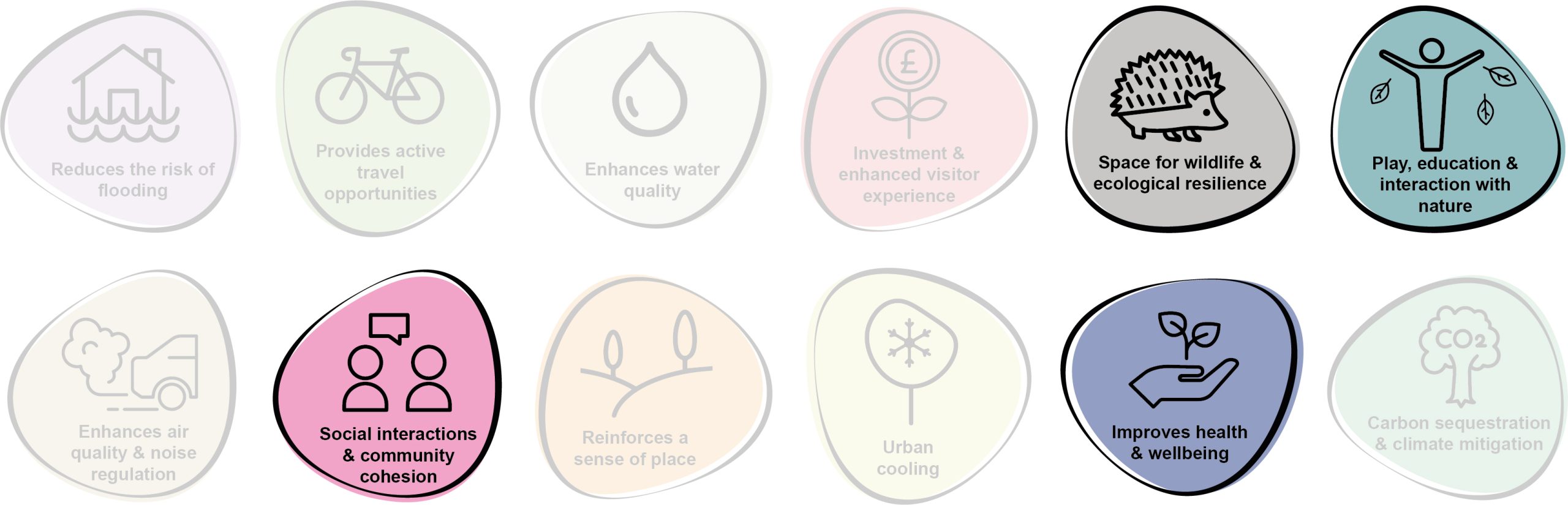
12.23 Benefits of the project, as depicted in Figure 12.7 below, include:
- Space for wildlife and ecological resilience
- Play, education and interaction with nature
- Social interaction and community cohesion
- Improves health and wellbeing
Figure 12.7: Benefits
Delivery mechanisms
12.24 Delivery would need to be achieved in partnership with St Telio’s RC Primary School. Much of the initial establishment works could be completed in partnership with the school, including tree planting and building items such as invertebrate hotels. Some horticultural and landscape management advice may be required from Pembrokeshire County Council (PCC) to oversee this. Ongoing growing and maintenance could largely be undertaken by the school with some support from the PCC StreetCare / Amenity Maintenance Teams.
Potential partners
- St Telio’s RC Primary School
- PCC StreetCare / Amenity Maintenance Teams
- Tenby volunteer tree warden (Tree Wardens Pembrokeshire)
- Pembrokeshire Nature Partnership
- Tenby Town Council
- Tenby Green Space Preservation Society
- Incredible Edible Network
- Groundwork UK
- Wales Biodiversity Partnership
- The Federation of City Farms and Community Gardens – Community Land Advisory Service in Wales and the Growing Together project
- Wild About Pembrokeshire
Outline cost
Low cost = <£250k
12.25 Interventions can be fairly simplistic and low cost. Establishment and management should be factored into costings.
Potential funding opportunities
- Local Places for Nature Fund
- National Lottery Community Fund
- Developer contributions
Timescale
Quick-term = 1-5 years
12.26 The project will likely take a year or two to get on the ground due to the need for engagement and fundraising.
Potential constraints
12.27 The project requires buy-in from the school as it will be a significant, yet rewarding, asset to take on. Securing appropriate investment for the growing space would be crucial for its successful delivery. Furthermore, sufficient resource to help in the initial establishment and ongoing maintenance will be essential for the continued success of the growing space, particularly those with some horticultural and landscape management knowledge.
12.28 Appropriate ground preparation and soil testing will be needed prior to delivery.
Maintenance and stewardship
12.29 The project will rely on the ongoing stewardship of the growing space to primarily lie with the school. This could be incorporated into existing maintenance regimes, as well as through outdoor learning and hands-on activities for the children. Additional support from the PCC StreetCare / Amenity Maintenance Teams should be provided to ensure the ongoing success of the space, both horticulturally and for wildlife.
Monitoring for success
12.30 The site could be included within PCC’s Wellbeing Plan. Overview measures of the children’s response to the growing space could be measured, for example, time spent outdoors, knowledge around where food comes from, willingness to try new fruits and vegetables, understanding of pollinators and the importance of biodiversity etc.
Next steps
12.31 Consult with St Telio’s RC Primary School to judge appetite for the project.
12.32 Engage with the PCC StreetCare / Amenity Maintenance Teams.
12.33 Undertake soil testing on the site to ensure the space would be suitable for growing edible items.
Figure 12.8: Tenby
TEN21 – Reconnect the floodplain and riparian environment on river banks
12.34 Situated within Flood Zone 3, land adjacent to the River Ritec is at risk from coastal surges and fluvial flooding. The opportunity exists to reconnect floodplain and riparian environments, restoring arable farmland along the riverbank back to its natural state.
12.35 Reconnecting the floodplain, planting trees and increasing the network of riparian habitat along the banks of Knightston Brook and River Ritec would help to reduce future surface water flooding in the area, helping to build climate resilience. Furthermore, the conversion of arable farmland into wetland habitat would further increase the biodiversity value of the area as well as provide tourism or fishing opportunities. This intervention would also help to improve water quality, reducing extracted water treatment costs downstream.
Figure 12.9: TEN21
Benefits of the project
12.36 Benefits of the project, as depicted in Figure 12.10 below, include:
- Reduces the risk of flooding
- Enhances water quality
- Space for wildlife and ecological resilience
- Enhances air quality & noise regulation
- Improves health and wellbeing
- Carbon sequestration & climate mitigation
Figure 12.10: Benefits
Delivery of nature-based solutions and ecosystem services
12.37 Population growth and demand for housing has resulted in the alteration of many floodplains across the UK into residential, commercial or agricultural land uses. Much of the floodplain of the River Ritec in Tenby has been converted to arable land, with a decline in tree cover and drainage of the land to maximise the efficiency of the farmland. This has resulted in a reduction of habitats and a loss of wetlands and associated wet terrestrial habitats. However, flood risk has increased. The landscape is now able to absorb much less rainwater and so offers less capacity to slow and reduce the volume of water flowing down rivers – the landscape, therefore, provides a reduced buffer in prolonged rainfall events. Reduction of wetland habitat and riparian environments also results in a reduction in carbon sequestration within the area.
12.38 The reintroduction of wetland and riparian habitats creates a store for excess surface run-off, reducing flood risk, and increasing water quality and on site carbon sequestration. Re-wetting of wetland soils would also increase their capacity to absorb and lock-in carbon. Reconnecting floodplains creates vital habitats for species such as waterfowl and juvenile fish breeding grounds, contributing to the wider biodiversity of the area.
Delivery mechanisms
12.39 Selected sites adjacent to the River Ritec and Knightston Brook would need to be identified and scoped out for their suitability. An ecological assessment of each site would be required. This scoping and assessment could be conducted by trained citizen scientists, Pembrokeshire County Council (PCC) staff or trained consultants. It would be necessary to engage with landowners and land occupiers / graziers in order to present this opportunity and discuss their impacts on current land-use.
12.40 We envisage the proposed physical interventions and amendments to land management could be delivered by the landowners themselves, or by external agricultural contractors.
Potential partners
- Landholders
- PLANED – Pembrokeshire Sustainable Agriculture Network (PSAN)
- Tenby Green Space Preservation Society
- Wildlife Trust of South and West Wales
- Natural Resources Wales (NRW)
Outline cost
Low cost = <£250k
12.41 Costs would comprise some limited specialist advice and land agent fees, soft landscape and tree planting costs. The construction of wetland scrapes would require contractors and machinery. An ecological assessment of the site would need to be undertaken by an ecologist with all site works potentially supervised by an Ecological Clerk of Works (ECoW).
Potential funding opportunities
- Pembrokeshire Coast National Park Authority (PCNPA)
- Emerging Welsh Government Sustainable Farming Scheme
- Resilient Communities Grant Programme
- Local Places for Nature Fund
- The Tree Council
- National Forest for Wales – The Woodland Investment Grant (National Lottery Heritage Fund – Round 1)
- NRW grants
- Nature Networks Fund
Timescale
Medium-term = 1-5 years
12.42 The main constraint to the programme for this project would be gaining landowner agreement. This could be a protracted process, but if concluded quickly then the implementation could be relatively rapid. A programme would need to allow for time to undertake hydrological modelling of the catchment and to obtain the necessary licences and permits to undertake the works. Physical interventions could be delivered within a single summer season, depending on contractor availability.
12.43 A key unknown for the project would be the time required to gain landowner / occupier / grazier agreements / consents.
Potential constraints
12.44 A key constraint for the project would be landowner / occupier / grazier agreements, as there may be a perceived risk to farm viability associated with some loss of land to riparian environments and wetland habitats. These concerns should be countered with the availability of agricultural payments for environmental goods and services, and hence the delayed launch of the Welsh Government’s Sustainable Farming Scheme is a potential constraint in this regard.
Maintenance and stewardship
12.45 Maintenance of the softworks and wetland area would be required as part of the 60 month establishment phase, including the replacement of failed trees.
Monitoring for success
12.46 Subject to availability of funding, monitoring of the success of the project should be undertaken through simple citizen science, with suitable support.
Next steps
12.47 Consult with PCC and NRW to identify if the project could align with the Strategic Outline Case for the River Ritec project which has been awarded funding from the Welsh Government.
12.48 Engage with landowners / occupiers / graziers and enter into agreements to deliver interventions on their land. Investigate the potential for nutrient credits to offset project costs.
Figure 12.11: Tenby
Project Long List
TEN1 – Promote greening of the Transport Hub
12.49 Enhance greening of the multi-storey car park with a cable supported green wall (including steel ropes, mesh and climbing plants) to provide space for invertebrates and birds, as well as trapping exhaust fumes. Bus stops should also be improved through the use of raised planters and retrofitting with green roofs, whilst ensuring proposals do not impede access for the mobility impaired. Where space permits, the lifting of slabs to deliver rain gardens could also be achieved. Furthermore, bulb and plug planting beneath trees should be explored in the area of amenity grass next to the bus stop, as well as additional pollinator-friendly planting within the Tenby War Memorial Garden.
TEN2 – Enhance the setting of Tenby Station
12.50 Introduce urban greening features at the entrance of Tenby Station to create a more welcoming gateway. Re-configure existing parking provision by the entrance to create raised planters, street tree planting and a secure cycle parking shelter with green roof. Improvements to wayfinding and signage should promote linkages to the town centre, Tenby Castle, Castle Beach and Tenby Harbour along Warren Street, as well as Tenby South Beach along Station Road. Proposals should also look to incorporate an active travel route connecting The Green with Tenby Station. Working with residents along Warren Street, locations for the planting of small street trees could also be identified.
TEN3 – Deliver greening interventions at the Town Wall
12.51 South Parade once hosted a row of chestnut trees which were diseased and removed over safety concerns. A replacement green corridor which introduces linear rain gardens in the original extent of the former tree pits should be installed. Designs should not affect the stability of the wall or screen views of the heritage asset. Flowering perennials, small shrubs and tree species would all provide an attractive and rich pollinator corridor. A review of other planting along South Parade and St Florence Parade should also be undertaken to create a plan for the renovation of shrub planting.
TEN4 – Promote greening of the High Street and St Julian’s Street
12.52 Explore options to reconfigure the junction between High Street, Church Street and St Julian’s Street to reclaim some car parking provision for tree and shrub planting. At present, the semi-pedestrianised space is cluttered with street furniture, including large numbers of bollards, benches and signage. The opportunity exists to remove some parking spaces (whilst retaining spaces for disabled, loading and 20 minute spots) on St Julian’s Street to allow for the introduction of parklets, raised planters, cafe spill out and sociable seating areas.
TEN5 – Introduce a circular walk to Scotsborough House
12.53 The ruins of the 17th century Scotsborough House is a Scheduled Monument and sits within an area of tranquil ancient woodland to the west of Tenby. An existing PRoW connects Tenby to this heritage asset from Scotsborough View and Serpentine Road. The opportunity exists to improve wayfinding provision as well as the creation of a recreational PRoW link between the two footpaths which run parallel to the wooded stream valleys.
TEN6 – Enhance the Battery Gardens for pollinators
12.54 The Battery Gardens currently provide a valuable number of pollinator-friendly flowering plants. However, this would be further enhanced through replacement of some ornamental species with native pollinator-friendly plants and the introduction of wildflower meadow at the perimeter of the park where strips of amenity grassland are present.
TEN7 – Encourage the establishment of pollinator-friendly flowering plants at Jubilee Gardens
12.55 The play park and skate park in Jubilee Gardens are currently bounded by steep grassy verges or rocky faces. Reducing the frequency of mowing at these locations and the addition of salt-tolerant plug plants would improve the attractiveness of the park, without compromising its recreation function. This would also provide important pollinator connectivity.
TEN8 – Increase biodiversity at St Mary’s Church
12.56 St Mary’s Church provides a number of opportunities to provide additional pollinator habitat within the centre of Tenby’s old town. The potential exists for volunteers / local groups to help with the planting of flowers, creation of deadwood piles and earthbanks. Churches often provide opportunity for all life cycles of pollinators and although the space is located within the heart of Tenby, it benefits from minimal disturbance.
TEN9 – Introduce native planting along the Esplanade
12.57 Pockets of ornamental plants currently exist at The Esplanade, specifically at the Atlantic Beach Gardens. This should be enhanced to include increased native flowering species. The siting of additional planters throughout the town centre offers the opportunity to provide more suitable pollinator habitat. Enhancements along The Esplanade would also complement similar initiatives taking place along the old Town Wall.
TEN10 – Provide a pollinator haven at Tenby Castle
12.58 Working in conjunction with Pembrokeshire County Council (PCC) Amenity Maintenance Teams, the extension of wildflower meadows and earth banks for pollinators at Castle Hill and Tenby Castle should be used to enhance the provision of pollinator habitat. Sightlines should be retained at this location for informal surveillance.
TEN11 – Enhance and promote Allen’s View
12.59 Working with Tenby Civic Society, introduce management practices which diversity the woodland ground flora at this wooded hilltop viewpoint. Consider the introduction of wayfinding to promote the public space from the Pembrokeshire Coast Path and support wider proposals to deliver an active travel connection from The Croft to North Beach Car Park.
TEN12 – Strengthen strategic green linkages at land lying between the Salterns Industrial Estate and the River Ritec
12.60 Refer to Kickstarter Projects.
TEN13 – Promote active travel mechanisms and safe routes to schools
12.61 Explore the opportunity to utilise the Welsh Government’s Safe Routes in Communities programme and Active Travel funding to introduce greening interventions as part of active travel schemes within the town, notably along Heywood Lane.
TEN14 – Enhance wayfinding and surfacing of NCN
12.62 Explore the opportunity to re-surface NCN route 4 as it passes Tenby Cemetery to increase the accessibility of the route to cyclists. The route lies within close proximity to the proposed development site at Bryn Hir and would provide a key active travel link to the town centre. Wayfinding between the town centre, Bryn Hir and the holiday park at New Hedges should also be improved. Alternative proposals should consider the installation of an active travel route linking Slippery Back with North Beach Car Park and onwards towards Tenby via The Croft.
TEN15 – Create a pollinator bank at Ysgol Greenhill School
12.63 Work in partnership with Ysgol Greenhill School to explore opportunities for a pollinator bank to the south of the main campus adjoining Marsh Road. Using the area to the west of the existing footpath offers the opportunity to create an undisturbed area for establishment of a wildflower meadow. The potential also exists for additional boundary tree planting along Heywood Lane on the north of the campus. This would complement the existing mature trees within the playing fields.
TEN16 – Deliver a growing space at St Telio’s Primary School
12.64 Refer to Kickstarter Projects.
TEN17 – Introduce tree planting within residential areas
12.65 Work with communities to identify areas of amenity grass within residential areas which are suitable for tree planting. Encourage community ownership of these trees to secure their long-term establishment e.g. watering, loosening stakes and mulching. To enhance the sense of community ownership, residents should be involved in the selection of species and planting. Suitable streets include Heywood Court, Rosemount Gardens, Newell Hill, The Gleve, Churchill Close and Tudor Way.
TEN18 – Promote the urban greening of key routes
12.66 Support the use of sympathetic design principles to introduce urban greening measures within spatially constrained spaces, such as around St. Mary’s Church and Upper Frog Street. In addition, explore the opportunity to strengthen key strategic green linkages, including the proposed active travel route from Penally into Tenby.
TEN19 – Introduce a pond, scrapes and Sustainable Drainage Systems (SuDS) infrastructure by The Marshes
12.67 This area is at a high risk of flooding and has been heavily flooded in the past. The creation a series of ponds and scrapes in the area would help improve biodiversity as well as act to potentially retain excess flood water during surge events.
TEN20 – Create wetland areas by the Tenby Wastewater Treatment Works
12.68 The Tenby Wastewater Treatment Works currently manages wastewater from both Tenby and Saundersfoot. Creation of a wetland on land adjacent to the works would serve to store floodwater and reduce flood risk downstream. The wetland habitat would act as a buffer for sewage outfall in periods of high volume and aid nutrient stripping. The intervention would also help to alleviate the discharge of nutrient loading further downstream.
TEN21 – Reconnect the floodplain and riparian environment on river banks
12.69 Refer to Kickstarter Projects.
TEN22 – Promote community food growing in Tenby
12.70 The opportunity exists to work with Pembrokeshire County Council to select an appropriate site to increase allotment provision within the town. The intervention should encourage plot owners to reduce the use of pesticides and herbicides, instead choosing to work the land organically. Additional tree and orchard planting opportunities should also be explored. Where possible, planting margins should be left uncut, sheds fitted with living roofs and bird feeders added to attract wildlife.
Previous Chapter:
St Davids
Return to homepage:
Homepage