
Page Contents:
A Portrait of Pembroke’s Green Infrastructure
Pembroke
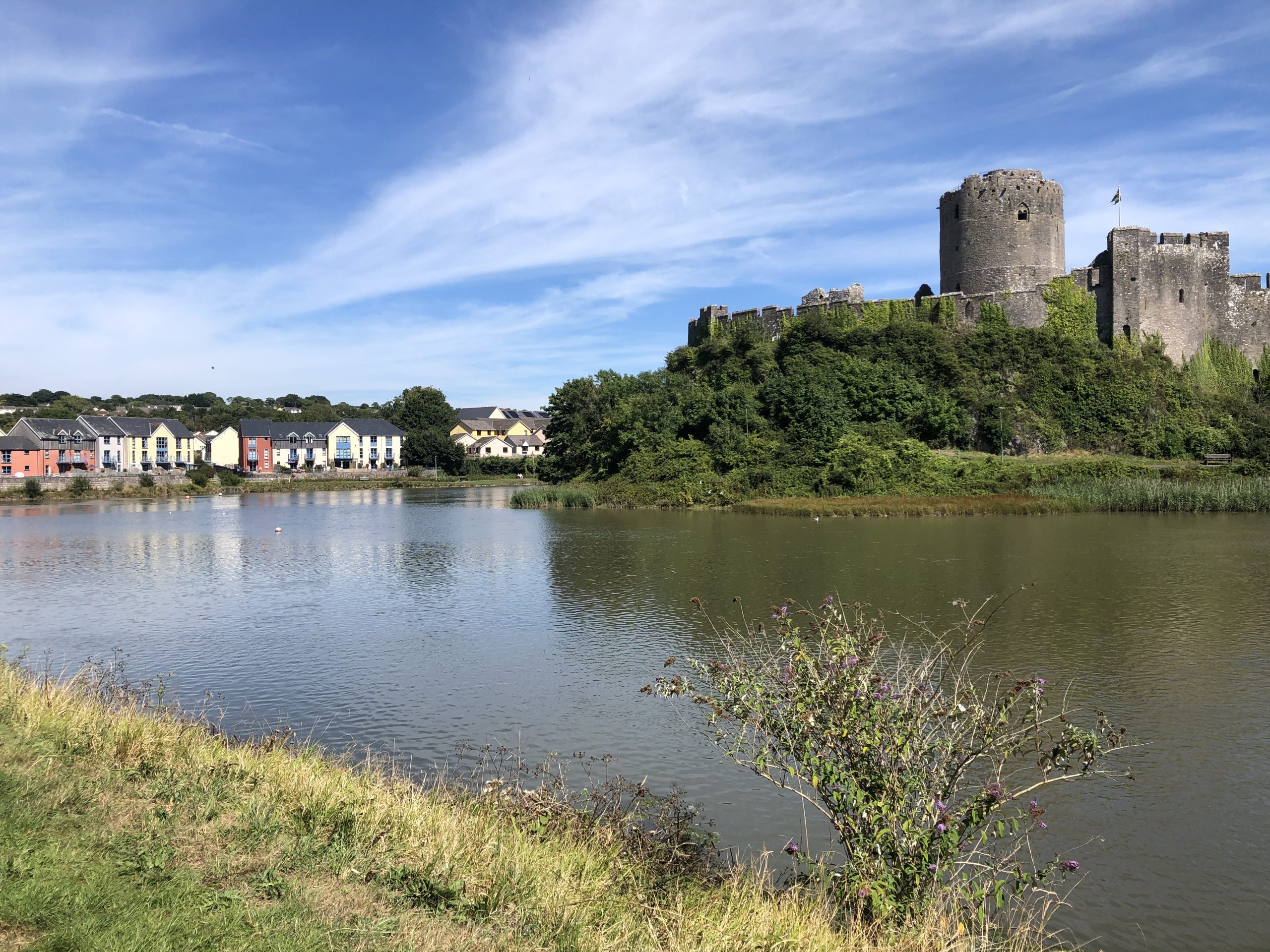
Figure 8.1: Pembroke
A Portrait of Pembroke’s Green Infrastructure
8.1 The ancient town of Pembroke retains a largely historic character within its densely settled core. Situated on a spit of land protruding into the Pembroke River and the Mill Pond, the old town centre is delineated by medieval wall foundations, associated with Pembroke Castle which is designated as a Scheduled Monument and a Grade I Listed building. Along Main Street leading to the castle are numerous listed buildings, contributing to the overall historic character.
8.2 Partially as a result of Pembroke’s heritage status, the town is well connected to the wider region. In addition to a railway station, there are a number of recreational walking and cycling paths that radiate from the town centre. Walking and cycling paths along the Pembroke River retain excellent views of the castle and historic town centre, making them popular with tourists. A National Trail, the Pembrokeshire Coast Path, follows the banks of the Pembroke River and along the western edge of town. National Cycle Network (NCN) 4 also passes through the town centre. However, some areas of the town, including the southern and north-eastern neighbourhoods, do lack access to the Public Rights of Way (PRoW) network, particularly where the railway line acts as a severing feature to movement.
8.3 Open spaces within the town are numerous and largely consist of recreation grounds or amenity green spaces. Upper Common and Lower Common are linear public parks just south of the town centre and are also well connected to the network of recreational routes. Multiple smaller open spaces are situated to the east and west of these parks and create opportunities for the further movement of wildlife.
Figure 8.2: GI Opportunities within Pembroke
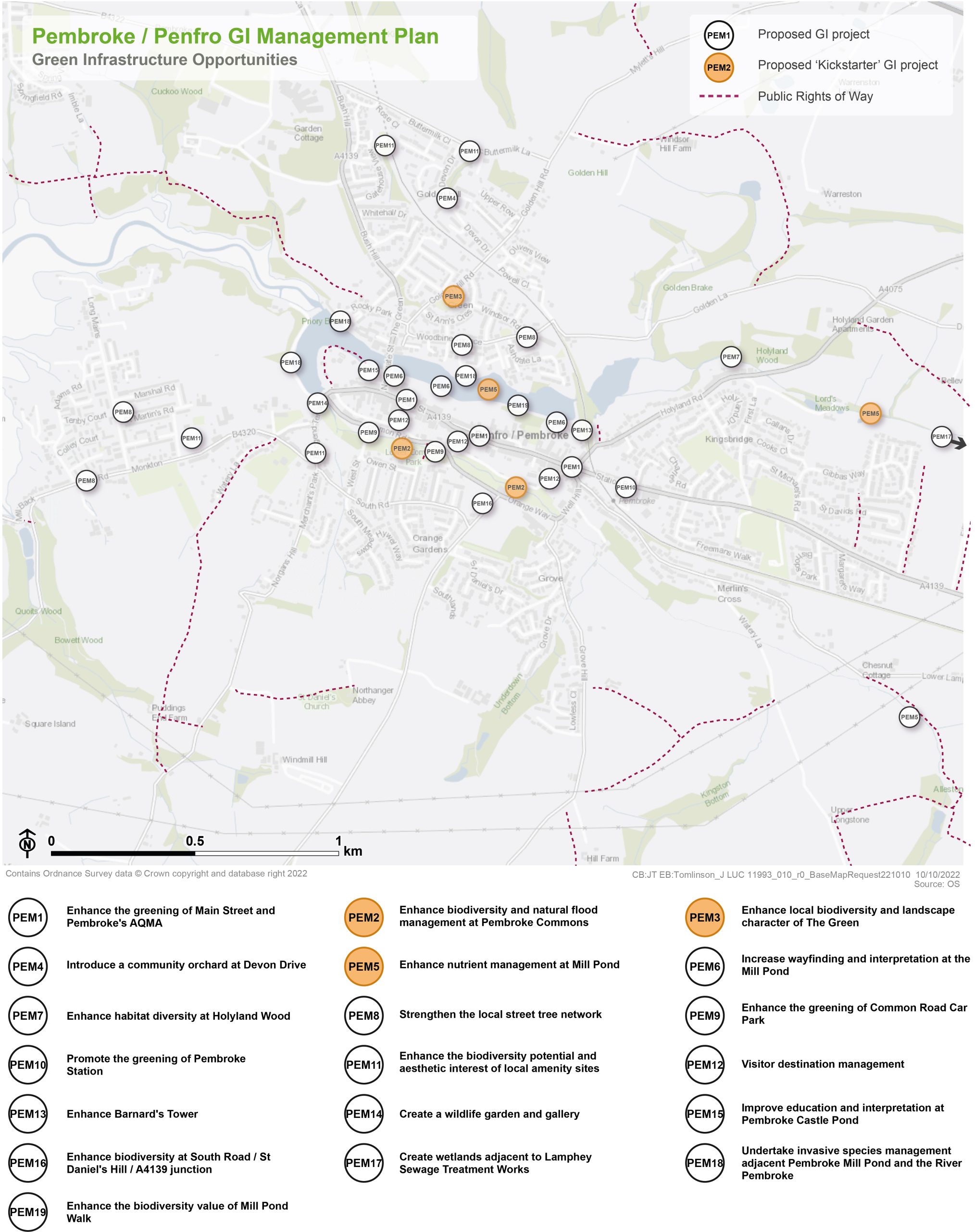
Kickstarter Projects
PEM2 – Enhance biodiversity and natural flood management at Pembroke Commons
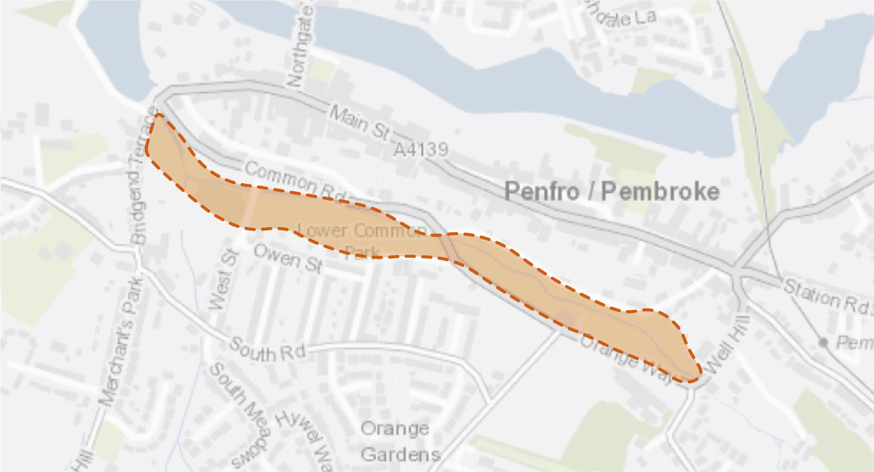
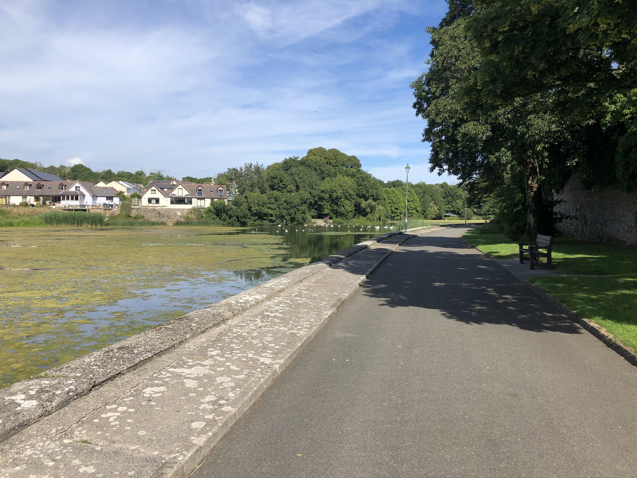
8.4 Land at Upper and Lower Commons is characterised by a linear open space approximately 850m in length, defined predominantly by multifunctional green space bisected by a brook. As the site lies within a flood zone, the opportunity exists to reconfigure some sections of the river channel within the Upper Commons to create wetland scrapes and flood retention areas. Scrapes support a diversity of aquatic wildlife, particularly wetland plants and insects such as water beetles, dragonflies and pollinating hoverflies. Consideration should also be given to the introduction of shrub understorey to enhance biodiversity, whilst ensuring the retention of sight lines. Continued clearance of hemlock (Conium maculatum) is also required along the river to promote the establishment of aquatic flora and allow water to flow efficiently during flood events.
8.5 Local Places for Nature funding has previously supported the establishment of wildflower meadows in the Upper and Lower Commons. These habitats have significantly enhanced the margins and paths through the green space. The extension of this intervention to create wet meadows in the Lower Commons would help create a large area of continuous pollinator habitat and help retain water on site.
8.6 A community orchard should also be created within the southern edge of the Lower Commons, set within species rich grassland. Eating, cooking and crab apple blossom between late April and May provides a much-needed early foraging source for honeybees, bumblebees, solitary bees and hoverflies. Later in the year, butterflies (including red admirals and painted ladies) would feed on the juices of fallen, over-ripe fruit. Apples are usually grafted onto a rootstock which determines how tall they grow and how quickly they come into fruit. Growing local varieties can also help local businesses promote their products.
8.7 To improve access and visual appeal, perimeter railings should be repainted, and dilapidated bridges restored or replaced. Proposed works should complement proposals to upgrade the existing network of footways to shared-user paths as part of Safe Routes in Communities funding.
Figure 8.3: PEM2
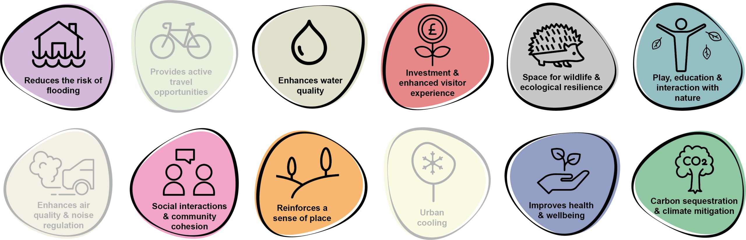
Benefits of the project
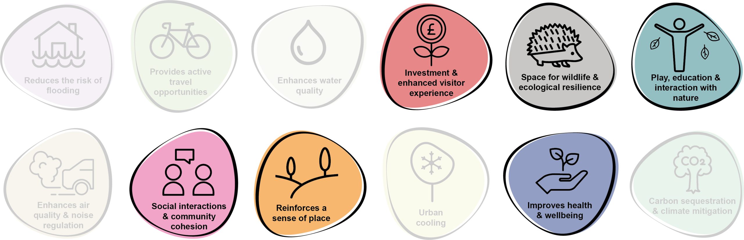
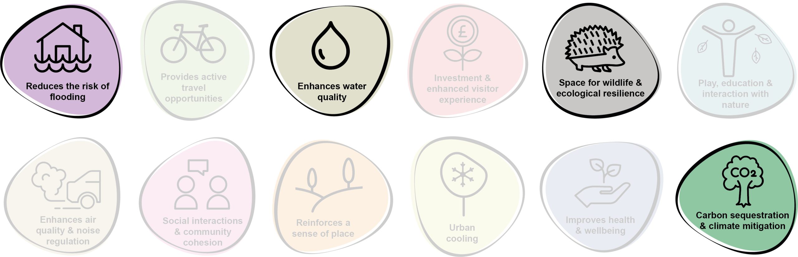
8.8 Benefits of the project, as depicted in Figure 8.4 below, include:
- Reduces the risk of flooding
- Enhances water quality
- Investment & enhanced visitor experience
- Space for wildlife and ecological resilience
- Play, education and interaction with nature
- Enhances air quality & noise regulation
- Social interaction and community cohesion
- Reinforces a sense of place
- Improves health and wellbeing
- Carbon sequestration & climate mitigation
Figure 8.4: Benefits
Delivery mechanisms
8.9 Wildflower meadows and the community orchard should be delivered in accordance with the Pollinator Strategy Delivery section.
8.10 Where feasible, delivery should be integrated into the work programme of the Pembrokeshire County Council (PCC) Amenity Maintenance Team. Contractors and / or additional machinery may be required to create the wetland scrapes and flood retention areas, as well as replacing the dilapidated bridges.
8.11 In order to avoid the growth of vigorous grasses, there may be a requirement to reduce soil fertility by stripping away the top 5-10 cm of soil in the area where the wet meadow is created. Autumn is the best time to sow wildflower seeds to have the earliest display of wildflowers the following year. However, wildflower seeds can be planted throughout the year and begin to bloom after approximately 60-80 days.
Potential partners
- Pembroke Town Council
- Pembrokeshire Local Nature Partnership
- Local businesses
- Pembroke 21C Community Interest Company
Outline cost
Low cost = <£250k
8.12 The cost of painting the railings and the new bridge crossings have previously been estimated as £45k. Cost of wildflower seed is likely to be low, although this would be higher if plug plants or wildflower turf are used.
Potential funding opportunities
- Local Places for Nature Fund;
- National Lottery Community Fund; and
- Safe Routes in Communities Grant
Timescale
Medium-term = (1-5 years)
8.13 Depending on soil fertility and if wildflowers are sown after Autumn, it may be the case that the seeds do not bloom until after their first winter season. Likewise, it may take a number of years for apple trees to mature and bear fruit as this would be dependent on which variety of apple tree is planted, soil conditions and the size of stock.
Potential constraints
8.14 The establishment of marginal aquatic vegetation and creation of flood retention areas would be important to the success of the meadow as otherwise nutrient enrichment during flood events may prevent the meadow from establishing.
8.15 Community or local business buy-in may be required to ensure long-term management of the orchards. Agreements may need to be reached on health and safety responsibilities and beneficiaries of resulting fruit. There is also a risk that the fruit trees may also be damaged from antisocial behaviour.
8.16 Hemlock is a poisonous plant. Cutting or mowing hemlock plants can cause resprouting and the emission of toxic fumes if they’ve already matured. The entire taproot needs to be removed to prevent the plant from regrowing.
Maintenance and stewardship
8.17 The detention / retention area may require basic mowing, vegetation management and general maintenance. In addition, erosion repair may be needed after a flood event. Overhanging or overgrown vegetation along the stream would also need to be routinely cleared. Mowing of areas of wet meadow would be required at the end of the flowering season, with arisings left in place for seven days to allow seeds to drop.
8.18 The local community should be engaged to act as stewards of the orchard. Maintenance pruning would be necessary to maintain the balance between fruit production and vegetative growth.
8.19 Management would be required to prevent weeds from competing with newly planted trees and meadow for water and nutrients.
8.20 Works on the brook should be scheduled during the late autumn and winter when the majority of aquatic fauna is overwintering and / or is less active through the water column.
Monitoring for success
8.21 If successful, the project should deliver a well-managed traditional orchard with a range of healthy young and old trees. This includes established wetland-grassland mosaic abundant with invertebrates, birds and wildflowers. Species richness surveys should be conducted to monitor success.
Next steps
8.22 Review the Delivery section of the Pollinator Strategy to determine the process and review case studies of creating wildflower meadows and community orchards. Review the Delivery section of the Urban Tree Planting Strategy to understand the key components for successful tree establishment.
8.23 Engage council members, residents and community groups to establish who would have overall responsibility for the orchard in the Lower Commons.
Figure 8.5: Pembroke

PEM3 – Enhance local and landscape character of The Green
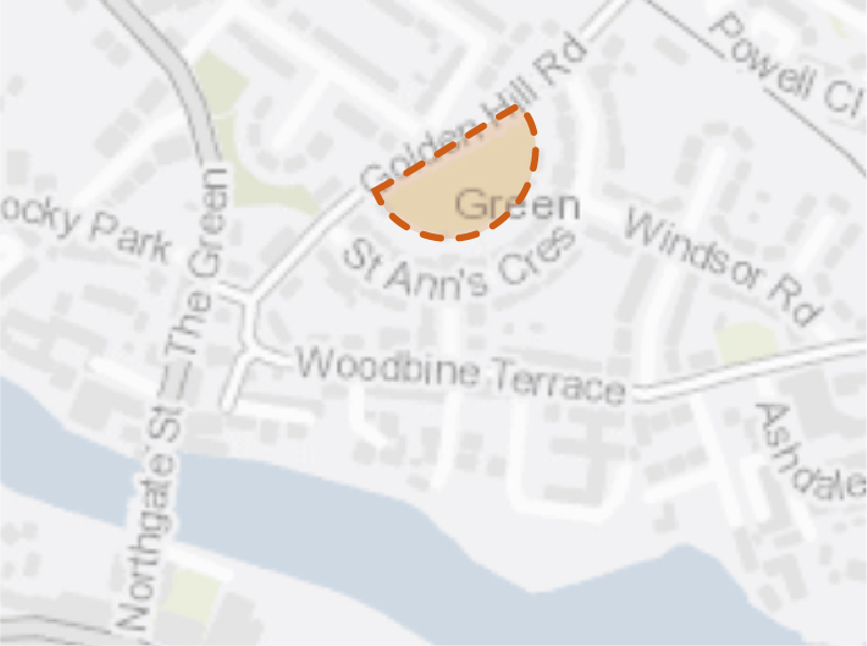
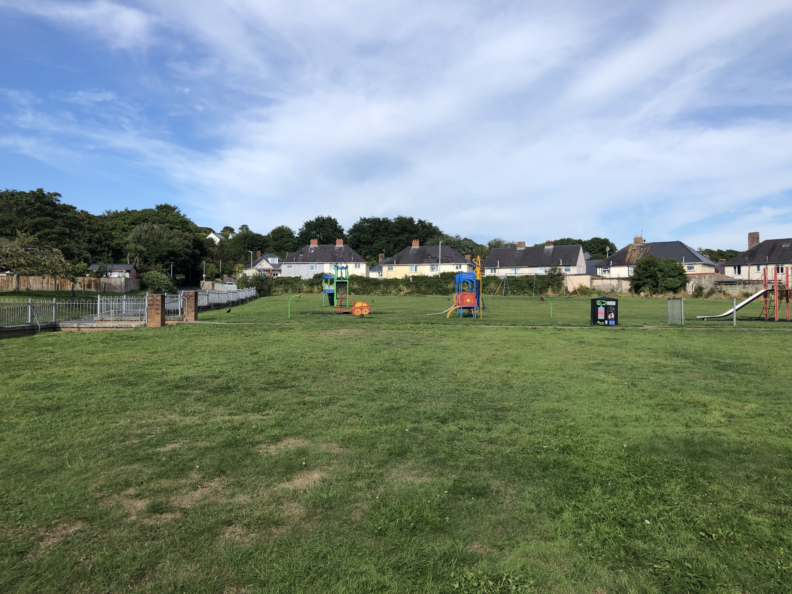
8.24 The Green forms a crescent-shaped piece of amenity greenspace bounded by the back gardens of St Ann’s Crescent and Golden Hill Road. At present, the space is characterised by a large swathe of short mown grass with metal play equipment, some of which is looking tired. The interface between back gardens and The Green is dominated by overgrown shrubs, brambles and bare breeze block walls. A number of tree stumps exist within this boundary, providing an important habitat feature for invertebrates. Some existing bulb planting, including daffodils, are also present along the boundary. Although there are no active residential frontages onto the space, The Green enjoys a relative degree of natural surveillance from nearby second floor windows and the Golden Hill Road, which is also a bus route.
8.25 This project should work with local residents to co-create a new space which is welcoming and accessible for all. This could incorporate a range of tree planting such as orchards, specimen trees, small copses and some boundary trees along the road (ensuring natural surveillance from the road and surrounding houses is maintained). Dilapidated play equipment should be replaced with natural play, including climbing boulders, stepping stones and balancing logs. Sociable swing sets, performance spaces, climbing bars and informal seating could be installed to create a more welcoming space for often forgotten demographics, such as teenage girls. The addition of wildflower swathes around the space’s boundaries would reduce the risk of trampling, whilst also creating quieter areas for people to sit, enjoy and interact with nature, as well as provide for additional habitat features such as log piles and bug hotels.
Figure 8.6: PEM3
Benefits of the project
8.26 Benefits of the project, as depicted in Figure 8.7 below, include:
- Reduces the risk of flooding
- Space for wildlife and ecological resilience
- Play, education and interaction with nature
- Social interaction and community cohesion
- Reinforces a sense of place
- Improves health and wellbeing
Figure 8.7: Benefits
Delivery mechanisms
8.27 It is essential that the design and delivery of this project is done in collaboration with the community to ensure the longevity and stewardship of the space.
8.28 Wildflower meadows significantly reduce resource inputs during the growing season. However, annual cuts of the meadow should be integrated into the work programme of the Pembrokeshire County Council (PCC) StreetCare / Amenity Maintenance Team.
8.29 Provision of pollinator habitat should be delivered in accordance with the delivery section of the Pollinator Strategy.
8.30 The delivery of successful tree planting schemes can be challenging and costly due to the time it takes for trees to reach maturity and the cost of purchasing established stock. The design of tree pits, the depth and soil used and the on-going watering and maintenance is vital in ensuring successful establishment and should therefore be carried out in accordance with the delivery section of the Urban Tree Planting Strategy.
Potential partners
- PCC StreetCare / Amenity Maintenance Team
- Local residents
- Tree Wardens Pembrokeshire
- Pembrokeshire Nature Partnership
- Pembroke Town Council
Outline cost
Low cost = <£250k
8.31 Cost of wildflower seeds would be lower, however, this would increase if plug plants or wildflower turf is chosen to create a more instant impact. The price of new trees would depend on the size they are purchased and the species. The largest capital investment for this project would involve the implementation of new play equipment. The delivery of fewer bespoke, hard wearing and attractive pieces should be prioritised over the delivery of a greater number of cheaper pieces of equipment.
Potential funding opportunities
- Local Places for Nature Fund
- National Lottery Community Fund
Timescale
Medium-term = 1-5 years
8.32 Depending on soil fertility and if wildflowers are sown after Autumn it may be the case that the seeds do not bloom until after their first winter season. Likewise, it may take a number of years for fruit trees to mature and bear fruit, depending on which variety of tree has been planted, soil conditions and whether seedlings or standards are planted.
8.33 Given the various aspects to the project and the need for extensive community engagement, the work may be staggered over a number of years.
Potential constraints
8.34 Community engagement and buy-in to the proposals would be needed for the long-term stewardship of the site.
8.35 Community or local business buy-in may be required to ensure long-term management of any orchard trees. Agreements may need to be reached on health and safety responsibilities and beneficiaries of resulting fruit. There’s a risk the fruit trees may also be damaged from antisocial behaviour.
Maintenance and stewardship
8.36 The space could be a largely community-managed asset with some input from the PCC StreetCare / Amenity Maintenance Team when machinery or horticultural input is required. Community stewardship is particularly important throughout the initial establishment years (60 months) to ensure trees are sufficiently watered during dry periods and stakes loosened when required.
8.37 The local community should be engaged to act as stewards of the orchard. Maintenance pruning would be necessary to maintain the balance between fruit production and vegetative growth.
8.38 Management would be required to prevent weeds from competing with newly planted trees and meadow plants for water and nutrients.
Monitoring for success
8.39 The survival rate of new planting and areas of meadow habitats established can be monitoring indicators for success. An annual community BioBlitz could be organised to record the variety of life within areas of the meadow, vegetation establishment and other habitat features. Engaging with citizen science projects such as the UK Pollinator Monitoring Scheme or organising an annual community BioBlitz at certain greenspaces can help involve local communities in monitoring efforts. This could also be done in partnership with local schools.
Next steps
8.40 Consult with PCC StreetCare / Amenity Maintenance Team;
8.41 Consult with local residents to determine what they want to achieve from the space and ensure a process of co-creation is adopted; and
8.42 Review the delivery sections of the Pollinator Strategy and Urban Tree Planting Strategy to review options for enhancing the biodiversity value of greenspaces.
Figure 8.8: Pembroke
PEM5 – Enhance nutrient management at Mill Pond
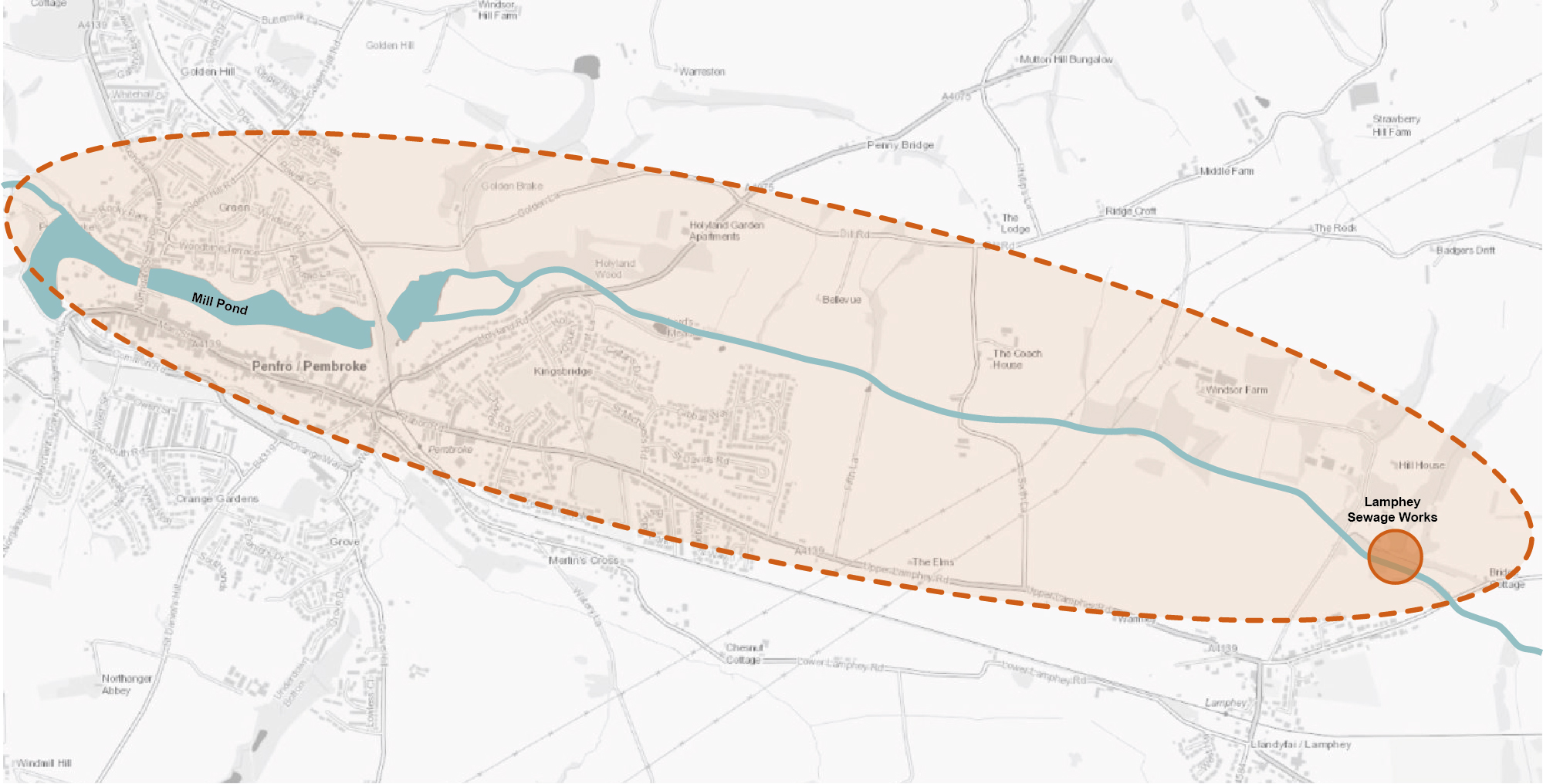
8.43 Nutrient run-off and sediment build-up into the Mill Pond has resulted in issues with algal growth. Significant areas of agricultural land in the catchment of the Pembroke River (which feeds the pond) is used for arable crop production, with periods of bare ploughed soil each year, and the associated applications of fertilizer. The immediate urban catchment of Pembroke may also contribute nutrients and sediment via stormwater discharge, with Dwr Cymru Welsh Water reporting five Combined Storm Overflows (CSOs) discharging around the Mill Pond area. The Dwr Cymru Welsh Water sewage works at Lamphey also discharges into the Pembroke River.
8.44 Tackling this issue should be on two twin tracks
Nature-based solutions
8.45 These should be utilised to tackle underlying agricultural causes. Previous projects have identified that there are areas of land where there are opportunities to implement changes to land management that would benefit water quality, reduce flood risk and decrease the risk of siltation of the River Pembroke and hence the Mill Pond. The entire catchment of the Mill Pond should be targeted for interventions, with a particular initial focus on the Pembrokeshire County Council (PCC) owned farms to the east of Pembroke, including between Lamphey and Alleston Wood.
8.46 A process of opportunity mapping using remote-sensing data has already been undertaken, and this has identified areas where changes in land management could deliver benefit. An initial data-gathering stage across the catchment of Pembroke River and the Mill Pond would provide local-scale ground-truthing of these opportunities, and identify areas where interventions could deliver benefit. This data-gathering and opportunity mapping stage could then swiftly be carried through to the delivery of a range of land-use change and interventions, which may include;
- Creating riparian buffer strips, reducing grazing in proximity to watercourses;
- Formalising areas of livestock watering, so enabling the erection of fences along the watercourse to protect from bank erosion, bank poaching and manure impact;
- Planting of field margins and shelter belts with trees / shrubs to increase water retention within tree and shrub planting;
- Creating natural dams within small watercourses, slowing flow and increasing diversity of habitats within the landscape; and
- Implementing a management plan for areas of reedbed at Mill Pond.
Urban run-off and foul sewage input
8.47 The second aspect to the project is to work with Dwr Cymru Welsh Water to investigate the degree to which stormwater, CSOs and the Lamphey sewage works contribute to nutrient enrichment in Mill Pond and deliver infrastructure improvement works to ameliorate this impact.
Figure 8.9: PEM5
Benefits of the project
8.48 Benefits of the project, as depicted in Figure 8.10 below, include:
- Reduces the risk of flooding
- Enhances water quality
- Space for wildlife and ecological resilience
- Carbon sequestration & climate mitigation
Figure 8.10: Benefits
Delivery of nature-based solutions and ecosystem services
8.49 Land use management since the Second World War has involved increased drainage of the land, in a drive to maximise the efficiency of farmland. This has led to a reduction in diversity of habitats, and the loss of wetlands, wet-grassland and associated wet terrestrial habitats. It has also increased flood risk, as it increases the speed and volume of water flow down catchments, reducing the buffering effect of the landscape during heavy and prolonged rainfall events. Increased drainage of wet soils also has a detrimental effect on the ability of soil to sequester carbon.
8.50 Through the use of techniques such as riparian buffer strips, reducing bank erosion and poaching, planting of shelter belts and field margins and the creation of natural dams within small watercourses, the ability of the landscape to absorb and buffer rainfall can be significantly increased. This would have a concomitant beneficial impact on flood risk, on water quality and on carbon sequestration, as re-wetting of wetland soils would increase their capacity to absorb and lock-in carbon.
8.51 The impact of nutrient enrichment from CSOs and sewage treatment plant outfalls is detrimental to habitats and species, and in extreme instances can lead to the death of the ecosystem. Addressing this impact would therefore have a beneficial impact on biodiversity, ecosystem resilience and on the ability of the ecosystem to act as a net sink for carbon.
Delivery mechanisms
Nature-based solutions
8.52 Initially, it is proposed that the project would be targeted on a local, site-specific level by undertaking a survey to ground-truth the presence and scale of opportunity areas that have been identified to date using remote-sensing techniques. This survey should be undertaken by suitably trained citizen scientists, Pembrokeshire County Council (PCC) staff or an external specialist consultant. Once areas of key opportunity have been ground-truthed and defined, it would be necessary to engage with landowners and land occupiers / graziers in order to present these opportunities and discuss their impacts on current land-use. This may lead to the loss of some opportunities for reasons of commercial and physical agricultural constraints.
8.53 The proposed physical interventions and amendments to land management should be delivered by the landowners themselves, or by external agricultural contractors.
Urban run-off and foul sewage input
8.54 Delivery of improvements on this aspect would require co-operation and involvement of Dwr Cymru Welsh Water. A strategic partnership between PCC and Dwr Cymru Welsh Water to investigate, assess and improve the situation in the catchment is required.
Potential partners
- Dwr Cymru Welsh Water
- Wildlife Trust of South and West Wales
- Natural Resources Wales (NRW)
- PCC
- West Wales Rivers Trust
- Pembroke Town Council
Outline cost
Nature-based solutions
Low cost = <£250k
8.55 It is envisaged that this project may cost tens of thousands of pounds or less, dependent upon the area of catchment targeted for interventions. Costs would comprise some limited specialist advice and land agent fees, fencing, tree planting costs and possibly costs associated with installation of alternative livestock watering apparatus.
Urban run-off and foul sewage input
Low cost = <£250k
8.56 Initial investigation and feasibility study.
Medium to high cost = <£250k- £1 million+
8.57 Delivery of interventions is anticipated to be medium to high in costs, alongside associated upgrades to infrastructure.
Potential funding opportunities
- Emerging Welsh Government Sustainable Farming Scheme
- National Forest for Wales – The Woodland Investment Grant (National Lottery Heritage Fund – Round 1)
- Dwr Cymru Welsh Water Asset Management Plan (AMP) budget for strategic upgrades
Timescale
Nature-based solutions
Quick win = <1 year
8.58 Physical interventions could be delivered within a single year. However, a key unknown for the project would be the time taken to gain landowner / occupier / grazier agreements / consents.
Urban run-off and foul sewage input
Quick win = <1 year
8.59 Initial investigation and feasibility study.
Medium-term = 1-5 years
8.60 Delivery of interventions is anticipated to be in the medium-term, alongside associated upgrades to infrastructure.
Potential constraints
Nature-based solutions
8.61 A key constraint for the project would be securing landowner / occupier / grazier agreements, as there may be a perceived risk to farm viability associated with some loss of land to riparian margins / shelter belts / field margin planting etc. There may also be resistance to alteration of watercourses with respect to land drainage concerns. Concerns should be countered with the availability of agricultural payments for environmental goods and services, and hence the delayed launch of the Welsh Government’s Sustainable Farming Scheme is a potential constraint in this regard.
Urban run-off and foul sewage input
8.62 A critical constraint to the undertaking of an assessment and feasibility project would be the willingness and co-operation of Dwr Cymru Welsh Water. The delivery of interventions to improve any identified CSO and sewage effluent issues would potentially be constrained by the availability of AMP funding through Dwr Cymru Welsh Water for upgrades, and the prioritisation of this catchment.
Maintenance and stewardship
8.63 Maintenance of the softworks would be required as part of the 60 month establishment phase, including the replacement of failed trees. If fencing is installed to keep livestock out of watercourses, there would also be a limited ongoing maintenance associated with the maintenance of this fencing.
8.64 Maintenance and asset stewardship for any infrastructure upgrades would fall under the statutory remit of Dwr Cymru Welsh Water.
Monitoring for success
8.65 Subject to availability of funding, monitoring of the success of the project should be undertaken through simple citizen science, with suitable support. Techniques could include monitoring of water quality using simple hand-held equipment, or installation of a simple stream-gauge to monitor streamflow, for example.
8.66 Monitoring of CSOs and Dwr Cymru Welsh Water performance in this regard should also be undertaken using citizen science.
8.67 Technical monitoring and asset stewardship for any infrastructure upgrades fall under the statutory remit of Dwr Cymru Welsh Water.
Next steps
8.68 Secure limited funding (£1k to £10k) to ground truth remote sensing across the catchment, creating a priority list of areas for intervention.
8.69 Engage with landowners / occupiers / graziers and enter into agreements to deliver interventions on their land.
8.70 Engage with Dwr Cymru Welsh Water to ascertain appetite and budget to progress with the assessment and feasibility study.
Figure 8.11: Pembroke
Project Long List
PEM1 – Enhance the greening of Main Street and Pembroke’s AQMA
8.71 Greening measures should be introduced along Main Street to help mitigate the issue of poor air quality. The narrow urban canyon of Main Street, coupled with the constraint of its use for events and proposed shared-user path, dictates that tree planting is only suitable in limited areas. Incorporate small, fastigiate specimens along the section of the route stretching from Northgate Street towards Brown’s Cafe. The re-purposing of some parking spaces to provide parklets could provide additional seating and spill out space, as well as excellent particulate capture. Elsewhere, raised planters, window boxes and hanging baskets should be installed.
PEM2 – Enhance biodiversity and natural flood management at Pembroke Commons
8.72 Refer to Kickstarter Projects.
PEM3 – Enhance local biodiversity and landscape character of The Green
8.73 Refer to Kickstarter Projects.
PEM4 – Introduce a community orchard at Devon Drive
8.74 Working in collaboration with the local residents to encourage community ownership, establish a community orchard within areas of existing amenity grass along Devon Drive. The proposals should include the sowing of wildflower meadow and adoption of relaxed mowing regimes to create wildflower meadows with mown paths and informal seating in glades
PEM5 – Enhance nutrient management at Mill Pond
8.75 Refer to Kickstarter Projects.
PEM6 – Increase wayfinding and interpretation at the Mill Pond
8.76 Enhance links from the town centre to the Mill Pond to encourage local residents and visitors to enjoy the Local Nature Reserve and the opportunities it offers to observe wildlife. Signage and wayfinding should be installed to enhance the perimeter route, including at Blackhorse Lane leading towards Barnard’s Tower. Consideration should be given to the establishment of regular events at Mill Pond Walk, including a monthly food market. The potential to integrate greening initiatives along the proposed shared-user path ordering the Mill Pond and connecting Barnard’s Tower with Mill Bridge should be explored. Urban greening interventions should also be incorporated on pedestrian linkages leading to and from Main Street.
PEM7 – Enhance habitat diversity at Holyland Wood
8.77 The structural diversity of the woodland and mosaic of wetland and grassland habitats should be enhanced. This should include coppicing areas of dense canopy to encourage the establishment of ground flora and retention of dead wood. Natural regeneration of trees should be promoted but additional tree planting could occur along the woodland edge to act as an interface between mature woodland and scrub. Removal of Himalayan Balsam and Japanese Knotweed should continue. Fencing around boardwalks should be installed to stop disturbance from dog walkers.
PEM8 – Strengthen the local street tree network
8.78 Explore opportunities to introduce additional street tree planting within areas of wide pavement and incidental grass areas / grass verges. This would address the gaps in strategic canopy cover, whilst also softening urban edges. Potential locations include Angle Rd, Long Mains, Golden Lane and Woodbine Terrace. The management of existing street trees should also be re-examined, ensuring tree stakes, grilles and guards are removed or loosened to accommodate growth.
PEM9 – Enhance the greening of Common Road Car Park
8.79 The opportunity exists to soften the largely hard-surfaced Common Road Car Park. Consideration should be given to the minor reconfiguration of some parking bays to allow the integration of street trees and urban greening solutions. Raised planters around bus stops and on redundant hard surfacing, alongside secure green cycle parking could also be introduced. These interventions would not only create a more welcoming gateway to Pembroke for visitors, but also reduce surface water run-off from the road towards adjacent watercourses.
PEM10 – Promote the greening of Pembroke Station
8.80 Consider the introduction of tree planting and raised planters to create a sense of arrival and soften hard landscapes / boundaries at the car park area adjacent to the station. The opportunity exists to integrate these features into proposed active travel connections which are currently in development. Secure cycle parking, seating provision and electric bicycle charging stations should also be explored to encourage the uptake of active travel.
PEM11 – Enhance the biodiversity potential and aesthetic interest of local amenity sites
8.81 Pembroke hosts a number of amenity greenspaces which are dominated by large swathes of close mown grass and little or no existing tree cover. Opportunities to introduce tree planting to provide shade, character and biodiversity should be explored, whilst also retaining recreation functions. Examples of potential sites include land at Back Terrace / Monkton, south end of Bridgend Terrace, Golden Hill Road / Elm Grove, Devon Drive, Gatehouse View and Buttermilk Drive.
PEM12 – Visitor destination management
8.82 Create a new entrance feature at Banker Walk to provide a direct link into the town centre from the Commons Car Park, maximising footfall. The existing access should be subject to regrading works to create a more accessible gradient and urban greening interventions introduced. A green wall and habitat management to clear invasive buddleia and encourage the establishment of native wildflowers would create an inviting entrance to the town. Consideration should also be given to the installation of improved wayfinding and ‘Welcome to Pembroke’ signage.
PEM13 – Enhance Barnard’s Tower
8.83 Barnard’s Tower is home to a colony of bats, including greater horseshoes. Interpretation measures, incorporating a live stream feed and signage, would help provide community education on the importance of these species and the role of woodland belts and river corridors as foraging and community routes. An amphitheatre should be created to provide an outdoor events space. In the setting of the Tower, wildflower meadow and trees should also be established to continue connectivity with Mill Pond Walk.
PEM14 – Create a wildlife garden and gallery
8.84 Develop a business plan for the Turner’s Reach Gallery and incorporate a native wildlife garden. Butterfly, bee and moth nectar borders, native tree, shrub and hedge planting and nest boxes and feeding stations for birds would provide connectivity with existing planting along the Commons and the Mill Pond. The gallery would support local artists and provide an additional tourist attraction.
PEM15 – Improve education and interpretation at Pembroke Castle Pond
8.85 Create an environmental visitor centre where live stream videos of bat colonies at Barnard’s Tower, the otter pass at the Mill Pond and wildlife along the estuary corridor can be shown to raise awareness of Pembroke’s important biodiversity assets. Improvements to local footpaths, including a proposed shared user path on Westfield Hill, and perimeter railings around Castle Pond should also be considered. The estuarine atmosphere could be enhanced through the planting of additional areas of wildflower meadow and bulb planting.
PEM16 – Enhance biodiversity at South Road / St Daniel’s Hill / A4139 junction
8.86 Plant additional large parkland tree species on the sloping green space at this junction, providing biodiversity opportunities and strengthening landscape character at this town centre gateway. Consider small scale landform modifications to reduce surface water runoff and create small seasonally wet areas habitat niches.
PEM17 – Create wetlands adjacent to Lamphey Sewage Treatment Works
8.87 High nutrient content and signs of eutrophication are evident at Pembroke Mill Pond. Conversion of vacant land adjacent to the sewage treatments works to the west of the town could act as a buffer for sewage outfall in periods of high volume. Wetland habitat would create new habitat for wildlife and aid nutrient stripping of the outfall, helping to alleviate the nutrient load which is currently discharged into the watercourse (and subsequently Pembroke Marine SAC located further downstream).
PEM18 – Undertake invasive species management adjacent Pembroke Mill Pond and the River Pembroke
8.88 Create a management plan which promotes positive management practices, including control of Common Reed (Phragmites australis) / Bulrush (Typha latifolia) and the implementation of a strategy to reduce invasive species adjacent Pembroke Mill Pond and the River Pembroke. In addition to the waterside environment, ecological surveys should be conducted to determine the existing species composition of adjacent woodland to encourage the preservation and enhancement of a rich understorey flora.
PEM19 – Enhance the biodiversity value of Mill Pond Walk
8.89 Introduce proposals to enhance biodiversity at the foot of the burgage walls / north walls along Mill Pond Walk. Proposals should be developed in conjunction with Cadw, Pembrokeshire County Council (PCC) and the Pembroke Town Walls Trust in recognition of the heritage constraints of the site and the historic medieval town walls. The opportunity exists to introduce locally appropriate ground flora and bulb planting to enhance pollinator and visitor interest.
Previous Chapter:
Neyland
Next Chapter:
Pembroke Dock
Return to homepage:
Homepage