
Chapter Contents:
Pembrokeshire’s Strategic Green Infrastructure
Current GI Resource
Climate Change Mitigation
Ecological Assets and Networks
Landscape Context
Pembrokeshire’s Strategic Green Infrastructure
4.1 Pembrokeshire is internationally important for many of its coastal, marine and lowland heathland habitats. The strong influence of the coast and the mild oceanic climate within the county are reflected in its pattern of land use, habitat and species distribution. The Eastern and Western Cleddau combine to form a significant catchment within the county. Inlets and estuaries range in size from the large and ecologically-rich Milford Haven Waterway and Daugleddau Estuary, to small inlets such as Solva. The southern shores of the Teifi Estuary also form a section of the county’s northern boundary.
4.2 Pembrokeshire is largely rural, with 56% of the land cover comprised of ‘enclosed farmland’ and a further 17% woodland, as described by the South West Wales Area Statement (Opens in new window).Traditional agricultural field boundaries, small copses and streams provide vital movement corridors for plants and animals, linking larger areas of woodland and scrub with fen and marsh on poorly drained valley bottoms. The county is also considered to be of national importance for ancient semi-natural oak woodland. Tracts of tree cover are predominantly confined to marginal agricultural land, reflecting the pattern of intensive farming within Pembrokeshire.
Figure 4.1: Strategic GI context- landscape down to project scale
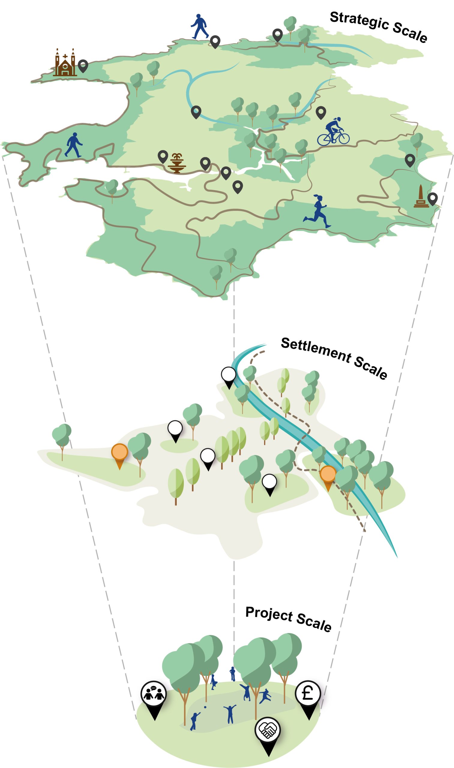
4.3 The strategic GI context of the county was explored as part of this work, prior to focussing in at the settlement and project scale. This included a review of landscape character, strategic active travel links, ecological corridors, river catchments and ecological sites of national and international importance. By understanding Pembrokeshire at the landscape scale and the relationship of urban environments to strategic corridors, links and sites, it has ensured that the settlement-based projects tie into Pembrokeshire’s strategic GI network.
4.4 This method aligns with the suggested approach to Green Infrastructure Assessment by Natural Resources Wales (NRW) in their Guidance Note 042. The interchangeable order of steps, shown below, ensures the appropriate scope and detail of evidence and data is used to inform interventions. This process is not intended to be linear and the revisiting of steps at different scales was undertaken to ensure appropriate priorities and opportunities were identified at the strategic, settlement and project scale.
Figure 4.2: Approach to GI Assessment by NRW

4.5 Approach to GI Assessment by Natural Resource Wales (as depicted in the figure directly above) includes:
- Setting the baseline
- Identifying priorities
- Site assessment
- Identifying opportunities
- Delivering & monitoring/review
Setting the Baseline
4.6 The identification of existing GI assets and networks formed an essential step in the GI assessment. Datasets were divided into the four categories, as defined by NRW (the ‘Current GI Resource’, ‘Climate Change Mitigation’, ‘Ecological Assets and Networks’ and ‘Landscape Context’). An overview of potential strategic GI opportunities and policy recommendations, informed by the strategic data analysis are outlined below.
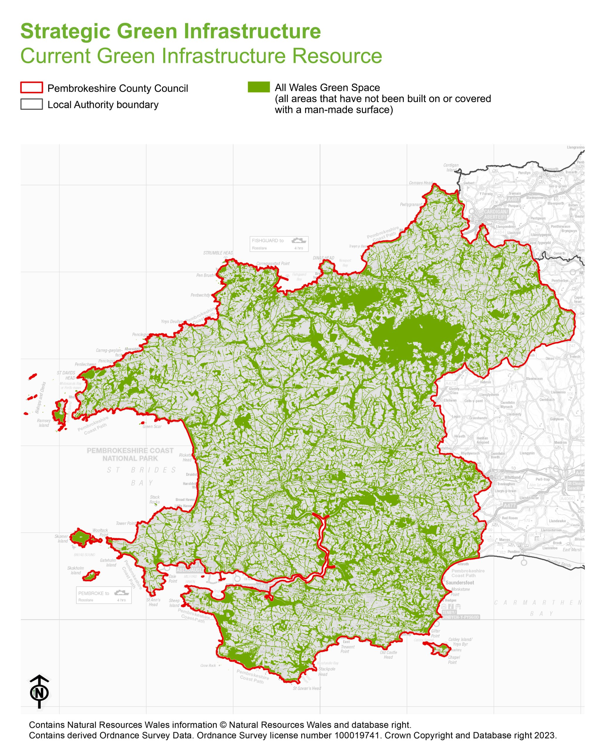
Current GI Resource
Relevant datasets
- The All Wales Green Space dataset – identifies all areas that have not been built on or covered with a man-made surface, providing an indication of current green space resource in Pembrokeshire.
- Urban tree canopy cover – shows the distribution of trees and indicative canopy spreads. This dataset encompasses key Pembrokeshire settlements only.
Figure 4.3: Strategic GI – Current GI Resource
Needs and opportunities
Address deficiencies in green space provision
4.7 Using the Fields in Trust standards of provision for Pembrokeshire, address local needs by identifying any shortfalls in recreational open space provision across the county. Opportunities should aim to deliver multifunctional value, including health, well-being benefits and biodiversity value. Accessibility deficiency mapping should also be examined to explore the need for improved access to open spaces for local communities.
4.8 Policy recommendation: Utilise the planning system and developer contributions to maximise the delivery of open space provision and enhancements across the county. This should include the establishment of principles for the provision of GI within new development e.g. open space standards and targets for biodiversity. Opportunities to enhance the biodiversity value of existing green space should also be explored through the requirement for management plans as part of the planning process.
Increase native woodland coverage
4.9 The potential exists to increase the resilience to pests and diseases and adapt to the long-term effects of climate change by promoting the diversity of native woodland in the county. A specific focus should be placed on opportunities to increase native tree cover within river valleys and restore coniferous plantations on ancient woodland sites. Proposals should be developed to ensure alignment with existing tree planting guidance, including the adoption of the principle of the ‘right tree, right place’ approach to woodland management.
4.10 Policy recommendation: Promote the protection and enhancement of native tree planting in river valleys by designating the NRW flood zone and ancient woodland sites on the Development Plan Proposals Map. Appropriate buffers should also be applied around woodland and development sites to reduce the potential for detrimental impacts on areas of priority habitat or ancient woodland.
Increase urban tree canopy coverage
4.11 Deliver wide ranging ecosystems services by increasing tree canopy coverage within urban settings across Pembrokeshire. All proposals should be in adherence to the Overarching Principles of the Urban Tree Planting Strategy to promote successful long-term establishment.
4.12 Policy recommendation: Utilise the planning system and developer contributions to maximise the delivery of tree planting opportunities within urban settings, as outlined in the ‘delivery’ section of the Urban Tree Planting Strategy.
Promote habitat connectivity
4.13 Utilise tree and hedgerow planting proposals as a mechanism to promote habitat connectivity. The adoption of wildlife-friendly management practices should be used as an approach to increase the foraging potential of existing habitats.
4.14 Policy recommendation: Protect habitat networks, including existing tree and hedgerows, from disturbance, deterioration or loss through the development management system. This should include the promotion of biodiversity enhancement interventions within development planning.
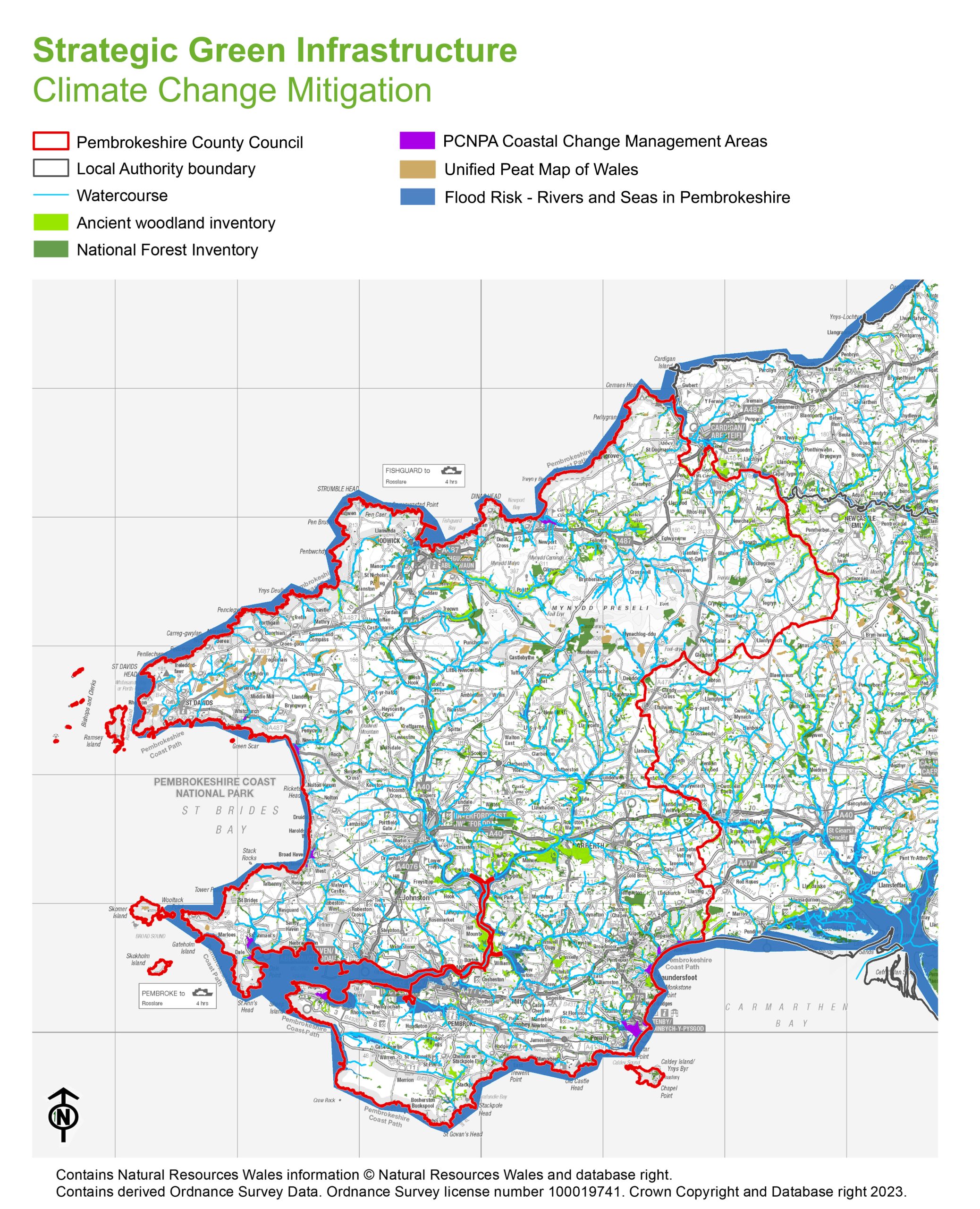
Climate Change Mitigation
Relevant datasets
- The Unified Peat Map of Wales – indicates the geographical extent of peatlands in Pembrokeshire, offering the potential to identify sites for peatland restoration (in conjunction with the NRW Welsh Information for Nature Based Solutions (WINS) Project).
- National Forest Inventory Woodland Wales – provides a breakdown of woodland types and distribution to inform future woodland planting proposals.
- Detailed flood risk maps – recognises areas at risk of surface water flooding, providing the starting point for the identification of areas that may benefit from GI interventions.
Figure 4.4: Strategic GI – Climate Change Mitigation
Needs and opportunities
Promote the sustainable management of peat resources
4.15 Opportunities to restore and maintain bog, fen and heathland habitat across the county should be explored, whilst acknowledging that the best option for peat on a development site is to design the development so that it is preserved in situ, wherever possible.
4.16 Policy recommendation: The Unified Peat Map of Wales should be designated as part of the Strategic GI on the Development Plan Proposals Map. Development proposals should be assessed to ensure adherence to Appendix 11 of the Authorities’ Supplementary Planning Guidance on Biodiversity, which provides detailed advice on peatland management. Appropriate grazing management approaches (including scrub clearance) on upland heath should also be promoted as a mechanism to achieve increased biodiversity.
Promote the protection and enhancement of the coastal zone or areas prone to flooding
4.17 A sustainable long-term approach to coastal erosion and flood risk management within Pembrokeshire is required to deliver a range of multi-functional benefits, including ecological enhancement within areas of flood risk. The opportunity also exists to support the introduction of nature-based solutions and Sustainable Drainage Systems (SuDS) as principles which maximise the benefits for water quality, biodiversity and amenity (whilst also reducing diffuse pollution and soil erosion).
4.18 Policy recommendation: The results of NRW’s flood zone mapping for land use planning purposes should be utilised to ensure that development is directed away from the coastal zone or areas prone to flooding. An appropriate buffer should be applied around defined NRW flood zone locations as a mechanism to promote the protection of these areas from development, as well as explore potential opportunities to enhance the habitat network. Climate Change Management Areas should also be included on the Development Plan Proposals Map to promote the opportunity for biodiversity enhancement and climate change adaptation in populated coastal areas. Feasibility studies and ground truthing will be required to assess the appropriateness of this recommendation.
4.19 Local policy should also make reference to the Welsh Government’s SuDS Statutory Guidance, which describes the mandatory use of SuDS for surface water on new developments. This also includes the requirement for approval and adoption by the local authority acting in its SuDS Approving Body (SAB) role.
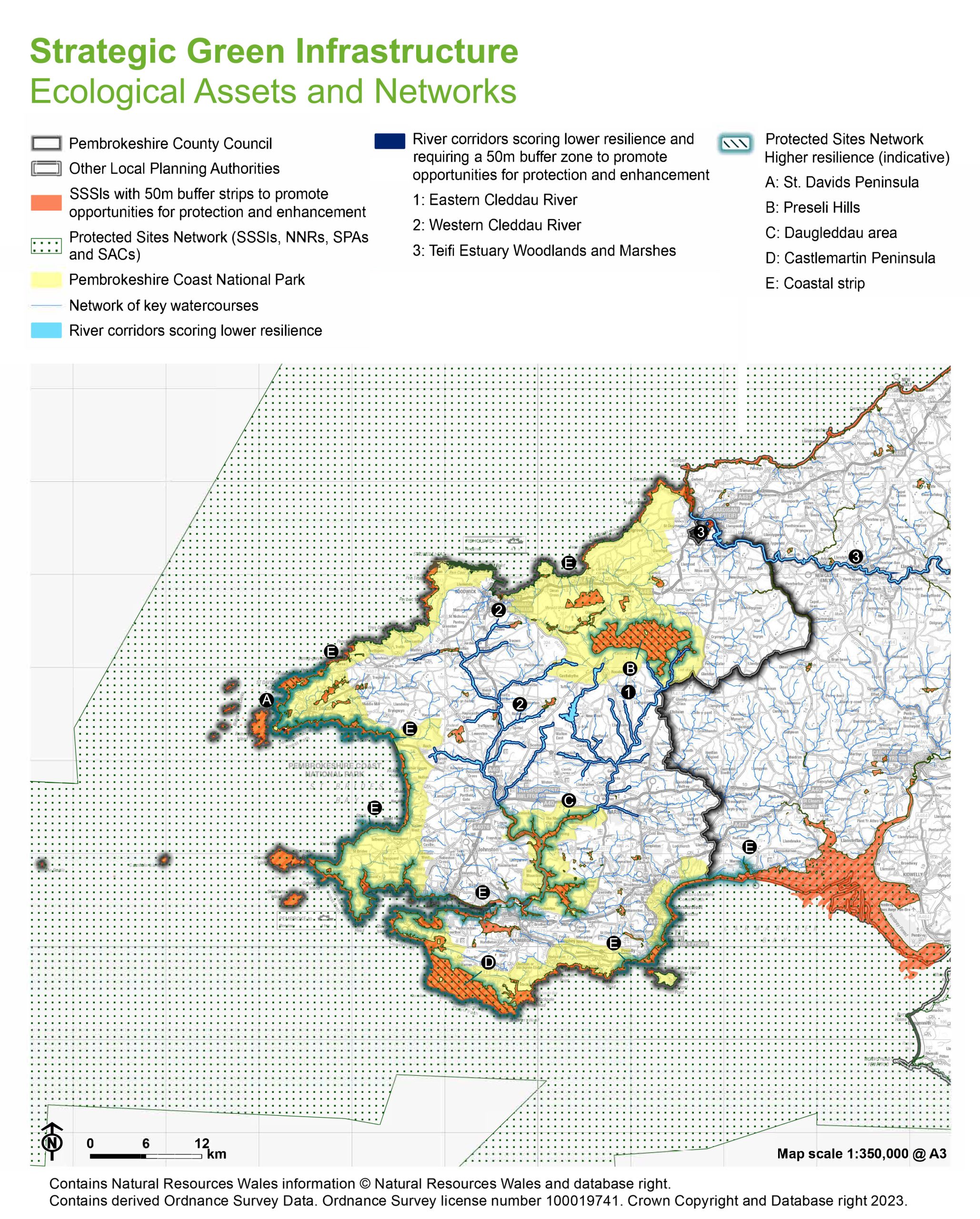
Ecological Assets and Networks
Relevant datasets
- The Protected Sites Network – combines Special Areas of Conservation (SAC), Special Protection Areas (SPA), Sites of Special Scientific Interest (SSSIs) and National Nature Reserves (which are also Sites of Special Scientific Interest).
- Phase I Habitat Survey – outlines comprehensive habitat data coverage.
- The Habitat Network – conveys general patterns of ecological connectivity across the landscape.
- CuRVe dataset – provides an overview of the relative ecological resilience of areas.
Figure 4.5: Strategic GI – Ecological Assets and Networks
Needs and opportunities
Working in conjunction with NRW, identify interventions to improve the condition of protected sites.
4.20 The opportunity exists to improve the ecosystem resilience of specific habitats, including the adoption of site-specific interventions where a species or habitat is considered locally important or at high risk. This includes the identification of sites where ecosystem resilience levels lie between 41 and 95 as per the CuRVe dataset – these locations include the Preseli Hills, St Davids Peninsula, Castlemartin Peninsula, Daugleddau and the wider coastal zone. Increased education and awareness regarding the management of protected sites should also be promoted, with the aim of striking a balance between recreational and ecological functions.
4.21 Policy recommendation: The Protected Sites Network should be designated as Strategic GI on the Development Plan Proposals Map and defined as an area to be protected. A buffer zone around SSSIs should also be applied to explore the potential of this network of sites for protection and enhancement. GI policies should be designed to protect and enhance onsite biodiversity and habitat networks within and adjacent to development sites. A ‘GI-led’ design approach should also be promoted within local planning policy, recognising the importance of the strategic GI network to establish opportunities for enhancement and mitigation. This includes the need to consider multi-functional GI design from the pre-application stage onwards, including through engagement with relevant stakeholders.
Promote the protection and enhancement of river corridors
4.22 A catchment-based approach is required to deliver enhancements to river corridors within the county. Key to this principle is the promotion of collaborative working, including as part of the Nutrient Management Plan Boards established for the Cleddau, Teifi and Tywi to deliver actions and achieve conservation targets. Opportunities to restore the riparian zone, utilise tree planting and improve the management of agricultural land should be explored as mechanisms to reduce diffuse pollution. Improvements to land management practices and riparian habitat restoration also offer the potential to reduce phosphorus concentrations in watercourses.
4.23 Policy recommendation: A buffer should also be applied around the watercourses on the Development Plan Proposals Map which currently exhibit low levels of ecosystem resilience as an approach to promote the protection and enhancement of these corridors. The locations that require particular focus are the Eastern and Western Cleddau, the Milford Haven Waterway, the Teifi Estuary and Carmarthen Bay. The proposed extent of these buffers should be explored through appropriate feasibility studies and ground truthing.
Landscape Context
Relevant datasets
4.24 LANDMAP – provides an overview of the GI assets that exist in an area and outlines how these contribute towards landscape character and sense of place. The Visual and Sensory aspect area can be used specifically to identify opportunities for improving characteristic landscape elements and enhancing lower quality landscapes in the county
4.25 Tranquil Area Map of Wales – indicates zones of existing tranquillity to inform where GI interventions could be used to improve perceived soundscape and relative tranquillity.
Figure 4.6: Strategic GI – Landscape Context
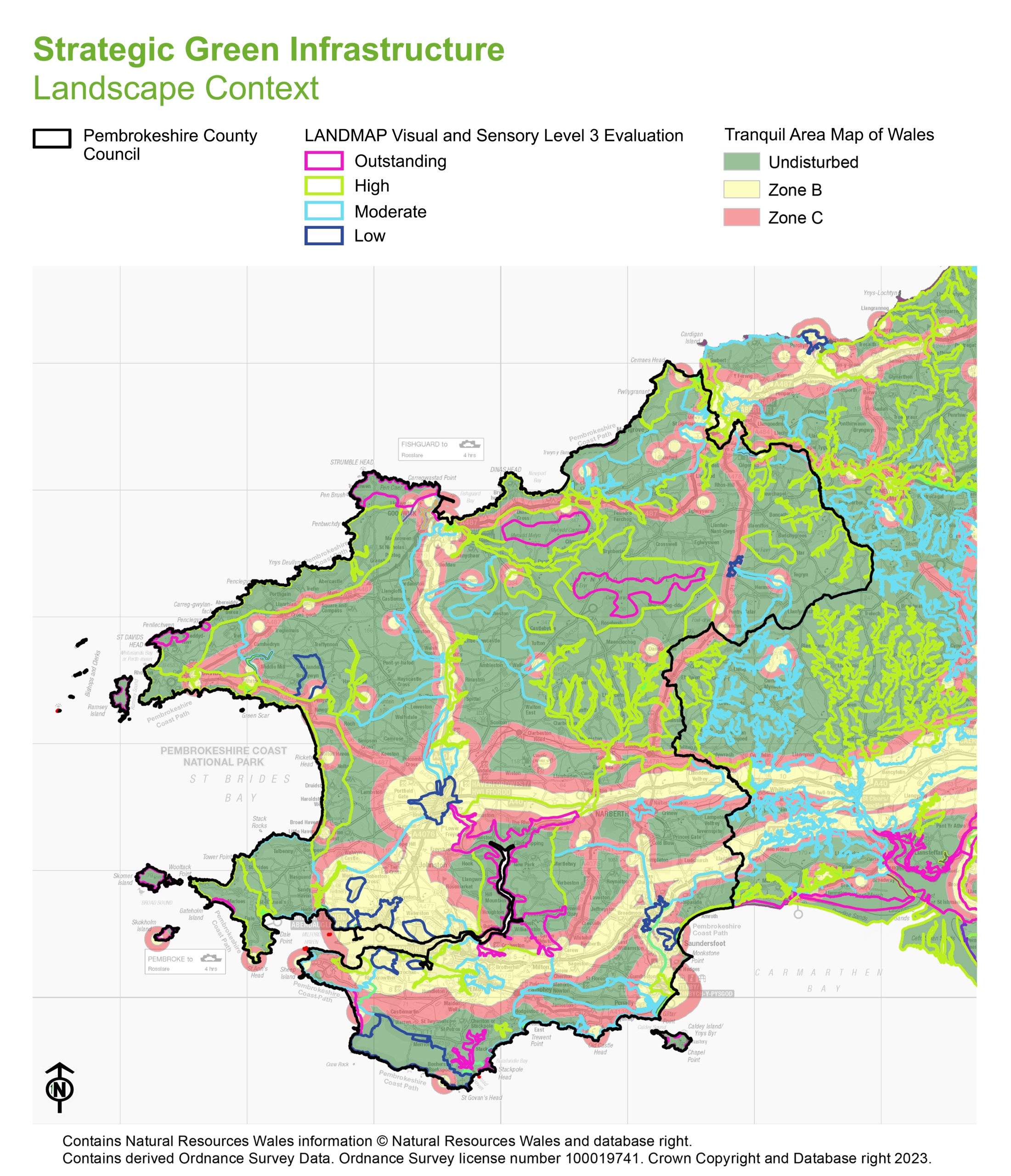
Needs and opportunities
Enhance landscape character and local distinctiveness
4.26 Informed by site context appraisal and spatial analysis, explore proposals which enhance landscape character, local distinctiveness and sense of place within the county.
4.27 Policy recommendation: Utilise LANDMAP data, specifically the evaluation data within the Visual and Sensory aspect area, to explore opportunities to reinstate lost features or enhance existing features through improvement, conservation and future change. Those areas assessed as ‘outstanding’ or ‘high’ should be included on the Development Plan Proposals Map. The dataset also offers the potential to enhance habitat connectivity and ecosystem resilience at a local level through the provision of finer grained detail regarding habitat mosaics, available as part of the Landscape Habitats aspect area. Furthermore, local policy offers the opportunity to set out and provide design principles for specific areas which exhibit local distinctiveness or sense of place. Consideration should therefore be given to long-term management and maintenance requirements in any planning consent or associated planning obligation.
Enhance the tranquillity and rural character of the county by reducing the effects of light pollution
4.28 The impact of artificial light pollution on local amenity and nature conservation should form a key consideration in the development of future proposals. This includes the identification of areas where lowering artificial light levels may improve the provision of habitat corridors for night foraging.
4.29 Policy recommendation: Utilise Tranquil Areas Map of Wales data on the Development Plan Proposals Map to identify existing tranquil areas as well as areas where GI interventions could improve relative tranquillity and perceived soundscape.
Previous Chapter:
How to use the Green Infrastructure Assessment
Next Chapter:
Pembrokeshire’s Strategic Scale Projects
Return to homepage:
Homepage