Probably the flattest section of the trail, but unfortunately much of it restricted because of military use. Despite being a firing range, because of it size (ten square miles), access restrictions and that it hasn't been cultivated or cropped for over 50 years, Range West ranks as one of Britain's most important wildlife sanctuaries and is protected by some of Europe's strongest designations. Much of the above can be experienced crossing Range East from Stack Rocks to Broad Haven South. Range East is open weekends, bank holidays and most evenings after about 4.30pm. but best to check with times with the recorded information on 01646 662367 or visit the Gov.uk website. There are no stiles on either route on this section.
1. Freshwater West to Bosherston (Range Closed) 7.2 Miles (11.27km)
It is worth finding out if the Range is completely closed in advance, because then the most appropriate route can be chosen (phone 01646 662367 to hear an answerphone message detailing the firing programme for the following day). They also state that “unscheduled firing may take place without prior warning, and firing may be cancelled without notice”.
When Castlemartin Range is completely closed, the route of the Coast Path is along the road. Follow the most southerly road that is not shut, onto the B4319, past the Merrion Army Camp and turn onto the very minor road through Lyserry Farm to Carew Farm then turn onto the ‘white road’ – this ‘white road’ is a public road in very poor condition. This road then joins the main road just short of Bosherston, turn due west onto the ‘white road’ 1/4 mile after Bosherston Church. The Castlemartin Range Trail, a permissive bridleway route, offers an off-road alternative. This route is waymarked with a tank symbol and in places crosses cattle farms. There are 31 wicket gates, and the route is currently maintained by the army. The section between Castlemartin and Warren offers panoramic views to the coast, right across the Range.
Walk Difficulty: Road
Car Park / Public Transport Access
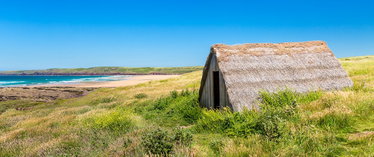
Freshwater West Main Car Park (Grid ref: SR88589951)
Bus stop (Coastal Cruiser – thrice daily return – Pembroke – Freshwater East – Bosherston – Angle – Pembroke). Large, free National Trust car park. WC.
Caution
Danger! Tanks – Range West (Grid ref: SR88739917)
Range West (Stack Rocks to Freshwater West) is never open to the general public, there is no right of way. However there are a number of guided walks led by National Park staff and Ramblers who have been specially briefed by the Army about safety and conservation concerns. Such walks only take place on some weekends and bank holidays. Contact the National Park Authority on 01646 624800 or visit our events page for details of guided walks.
Information
Range East – Danger Zone (Grid ref: SE91549831)
Normally the Coast Path, and bridleway, from St Govan’s to Stack Rocks (Range East) is closed weekdays from 9am to 4.30pm. There is also night firing on about half of these days, closing the section from 6.30pm to 11.30pm. On about a quarter of these days the Coast Path, and footpath, section from St Govan’s to Broad Haven South is also closed. This means that to be sure of being able to walk on Range East in advance – plan for weekends. Phone 01646 662367 to hear an answerphone message detailing the firing programme. They also state that “unscheduled firing may take place without prior warning, and firing may be cancelled without notice”.
2. Castlemartin to Stack Rocks (Range East Open) 3.1 Miles (4.83km)
Range West is always closed except to guided walks. After walking to Castlemartin, turn right at the cattle pound roundabout, then right again (after about two miles) at the sign to Stack Rocks. The Coast Path rejoins the coast at Stack Rocks.
Walk Difficulty: Road
3. Stack Rocks to St Govan’s 3.1 Miles (4.83km)
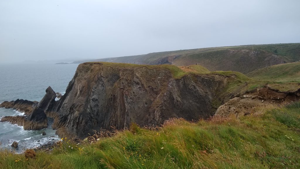
Bridleway – some way from the cliff edge, but there are informal paths along the cliff. The bridleway is partly stone track, partly asphalt road. Very slight gradients, no stiles or steps, seven gates. The cliffs are mostly vertical (don’t stand on the edge) with examples of all the limestone features one could wish for. A number of Iron Age forts guard promontories along the way.
Walk Difficulty: No man-made obstructions to wheelchairs, ground conditions vary
Caution
Danger! Tanks – Range West (Grid ref: S92369451)
Range West (Stack Rocks to Freshwater West) is never open to the general public, there is no right of way. However there are a number of guided walks led by National Park staff and Ramblers who have been briefed by the army to recognise safety and conservation concerns. Such walks only take place on some weekends and bank holidays. Contact the National Park Authority on 01646 624800 or visit our events page for details of guided walks.
Car Park / Public Transport Access
Stack Rocks Car Park (Grid ref: SR92549465)
Bus stop – Bank Holiday Mondays, Saturdays and Sundays only. (Coastal Cruiser – thrice daily return – Pembroke – Freshwater East – Bosherston – Angle – Pembroke) Free, National Park car park may be closed during firing times.
Walking Access Point
Green Bridge and Stack Rocks (Grid ref: SR92549465)
Grass path – short turf. Gradient less than 1 in 20; cross fall is negligible. In season razorbills and guillemots nest on stacks. Beware of slight slope leading to sheer cliff! Closed during Army range firing times, usually open evenings and weekends. For firing times tel. 01646 662367. Picnic tables. Toilets at Freshwater West (not nearby). Wheelchair 300m.
Walking Access Point
Stack Rocks to St Govan’s (Grid ref: SR92589446)
Green Bridge – Stack Rocks to St Govan’s SR925946 to 967931 bridleway with various surfaces. Viewing platform at Stack Rocks. Gradients to Fieldfare standard; cross fall is negligible. Track in most cases not immediate to the cliff, but commands fine views over limestone cliff scenery. Because of variable nature of surface and length involved this stretch may be more suitable for adventure chairs. Users of electric chairs report they have completed the route. Even on cool, sunny days the sunburn effect can be serious, sunscreen and water should be carried (and chocolate!). Closed during Army range firing times, usually open evenings and weekends. For firing times tel. 01646 662367. No seats. Toilets at Freshwater West (not nearby) and Bosherston car park. Five difficult gates. Cross country 4.5km.
Caution
Sheer Limestone Cliffs (Grid ref: SR92589446)
Beware of unguarded and eroding cliff edges. The cliffs look strong but the edges crumble! Beware of blowholes and sudden drops. The Coast Path is well inland of the cliff.
Worth a look
Green Bridge and Stack Rocks (Grid ref: SR92589446)
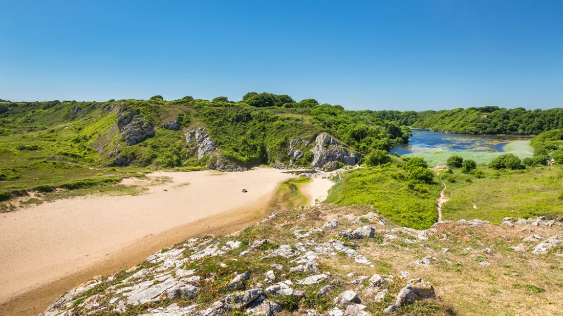
One of Pembrokeshire’s most famous geological features, a natural arch known as the ‘Green Bridge of Wales’. Arches are usually formed by the sea cutting through a narrow headland. Near the Green Bridge are two immense pillars known as the Stack Rocks or Elegug Stacks. These were once part of another arch which has now collapsed. The stacks and cliffs provide nesting ledges in spring and summer for a wide variety of seabirds including guillemots (‘heligog’ in Welsh), razorbills, kittiwakes, fulmars and cormorants. You may also see choughs and peregrines along this stretch of coast.
Worth a look
Flimston Castles (Grid ref: SR92999466)
An Iron Age Promontory fort, one of over 50 Neolithic settlement sites to be found along the Pembrokeshire Coast Path National Trail. There are three forts on this section, and signs of habitation in the caves on the cliff face. During the ice age these cliffs looked out across woodlands, the sea was further away.
Beach
Bullslaughter Bay (Grid ref: SR94169430)
Medium sandy beach with difficult access.
Information
Castlemartin Range (Grid ref: SR956934)
This military range was established in 1939, when war in Europe looked imminent. The Ministry of Defence now has around 2,400 hectares (5,900 acres) here for training and exercises. Other NATO countries also occasionally use the range. The military presence restricts public access, and therefore limits the National Park’s role in promoting enjoyment of the countryside, but there are advantages for conservation. The land is largely untouched by residential development and free of the chemicals and fertilisers used in modern farming. This has allowed wildlife to flourish. A group of specialists from Natural Resources Wales, the National Park Authority and other organisations keep a watching brief on the area and advises the Army on conservation.
Worth a look
Huntsman’s Leap (Grid ref: SR96169303)
Huntsman’s Leap is a narrow steep-sided inlet formed by sea erosion along a fault line (the technical term is a ‘geo’). Legend has it that a huntsman urged his horse over the chasm, landed safely, then looked back and dropped dead from shock when he saw the area he had jumped over. Next to this inlet is another geo, known as Stennis Ford, which probably takes its name from the Norse ‘fjord’.
4. Bosherston to Broad Haven South (Range East Closed) 1 Mile (1.61km)
The northern half of this section crosses two long narrow causeways and is quite hilly in between, although the hills are not very steep. 61 steps, no stiles or gates. The southern half is prepared for wheelchairs, accessed from Home Farm. Bosherston Lily Ponds are owned by the National Trust, as is most of the route to Freshwater East. The lilies are at their best in June. (Start/finish point is the junction of the routes at Lily Ponds outfall).
Walk Difficulty: Stiles or flights of steps or steep hills
Facilities
Bosherston Village (Grid ref: SR96609466)
B&B, St Govan’s Inn.
Car Park / Public Transport Access
Bosherston Church (Grid ref: SR96619477)
Bus stop (Coastal Cruiser – thrice daily return – Pembroke – Freshwater East – Bosherston – Angle Pembroke).
Car Park / Public Transport Access
Bosherston Car Park (Grid ref: SR96669483)
Large, National Trust car park; charges in season, Accessible WC.
Information
Bosherston Lily Ponds (Grid ref: SR97469460)
The Bosherston lakes were part of the Stackpole Estate. In the 18th century the estate was owned by the Campbell family, Earls of Cawdor, who created the lakes by damming three limestone valleys. In 1977 the National Trust took over 810 hectares (2,000 acres) of the estate. The lakes cover 32 hectares (80 acres) and support a rich variety of wildlife including otters, waterfowl, dragonflies and water lilies. They now form part of a National Nature Reserve managed jointly by the National Trust and Natural Resources Wales.
Walking Access Point
Bosherston Ponds Easy Access (Grid ref: SR97569474)
Parking is available for several cars on the far side of One Arch Bridge SR97729622. The path leads straight ahead from the car park, past the site of Stackpole House (demolished), and then leads down to the lakeside. This descent is fairly steep, but it can be managed, uphill as well as downhill, with a reasonably strong helper. Along the lakeside, the path is fairly flat, but with a few short steeper parts. At the end, it leads right onto Broad Haven (South) beach, but the sand on the beach is too soft for most wheelchairs. We would classify it as ‘adventure’, about 2.3km from the car park one-way. Contact the National Trust office for a leaflet (01646 661452 or 661359).
Walking Access Point
Grassy Bridge Permissive Path (Grid ref: SR97569474)
National Trust permissive path joins here, offering a large circular walk via the Eight Arch Bridge and Stackpole Quay (1.7 miles). The Eight Arch Bridge and Stackpole Quay Section is owned privately – access is by permission and on occasions this path is closed. It is also surfaced for wheelchairs, enabling wheelchair access from Home Farm to The Outfall (water outlet from the lakes).
Walking Access Point
The Outfall Path Junction (Grid ref: SR97729435)
Four footpaths join here. The main route of the Coast Path from Broad Haven South (car park, WC), across the sands. A National Trust permissive path and a public footpath that offer links to the minor road. A public footpath that provides a return to Bosherston Church car park along the south west side of the lake.
5. St Govan’s to Broad Haven South 1.4 Miles (1.61km)
This section is public footpath (now permissive bridleway to Broad Haven South car park, not to the beach). Two short steep hills, three gates, no stiles, 30 steps on the beach access. The limestone features continue. (Start/finish point is the junction of the routes at Lily Ponds Outfall).
Walk Difficulty: No man made obstructions to wheelchairs, ground conditions vary
Information
Limestone scenery (Grid ref: SR96859229)
The southern part of the Castlemartin Peninsula is a flat plateau, ending in spectacular vertical cliffs. The rock is Carboniferous limestone, about 350 million years old. The plateau was formed by marine erosion when the sea level was much higher than today, then lifted up by movements of the Earth’s crust about 50 million years ago. Between Flimston Bay and Mewsford Point, the limestone has been buckled in a series of folds, caused when drifting continents collided at the end of the Carboniferous period, about 290 million years ago. The cliffs along this stretch of coast are popular with rock climbers, but restrictions are agreed each year between the British Mountaineering Council, the National Park Authority and other conservation agencies, so that cliff nesting birds are not disturbed.
Car Park / Public Transport Access
St Govan’s Car Park (Grid ref: SR96719305)
Bus stop – Bank Holiday Mondays, Saturdays and Sundays only. (Coastal Cruiser – thrice daily return – Pembroke – Freshwater East – Bosherston – Angle – Pembroke) Free, National Park car park.
Walking Access Point
St Govan’s Head (Grid ref: SR96719305)
Tarmac road. Gradients to Fieldfare standard; cross fall is negligible. Cattle grid bypassed through wicket gate with strong spring. (Cross country chairs may be able to negotiate a further 1km to Broad Haven South.) Closed during Army range firing times, usually open evening and weekends. For firing times tel. 01646 662367. No seats. Toilets at Bosherston and Broad Haven South car parks. Wheelchair 0.9km.
Information
St Govan’s Chapel (Grid ref: SR96709297)
The tiny chapel of St Govan is tucked into a cleft at the foot of the cliffs. It is reached by a steep, uneven flight of steps. Tradition says these can never be correctly counted. The chapel dates from the 13th century but its foundations are thought to be much older. St Govan was probably Gobhan, an Irish abbot who retired to live here as a hermit in the 6th century, but he is sometimes identified with the Arthurian knight Sir Gawain. On one occasion, St Govan is said to have hidden from pirates in a narrow fissure near the altar, leaving the imprint of his ribs in the rocks. Below the chapel is a holy well, believed to cure eye problems, rheumatism and lameness. Even in the 19th century, the altar was frequently covered in abandoned crutches. If you visit the well between March and July, please don’t wander along the base of the cliffs, as this disturbs nesting birds.
Caution
Sheer Limestone Cliffs (Grid ref: SR96709297)
Beware of unguarded and eroding cliff edges. The cliffs look strong but the edges crumble! Beware of blowholes and sudden drops. The Coast Path is well inland of the cliff.
Caution
Range East – Danger Zone (Grid ref: SR9762356)
Normally the Coast Path, bridleway, from St Govan’s to Stack Rocks (Range East) is closed weekdays from 9am to 4.30pm. There is also night firing on about half of these days closing the section from 6.30pm to 11.30pm. On about a quarter of these days the Coast Path, footpath, section from St Govan’s to Broad Haven South is also closed. This means that to be sure of being able to walk on Range East in advance – plan for weekends. Army phone 01646 662367 to hear an answerphone message detailing the firing programme. They also state that “unscheduled firing may take place without prior warning, and firing may be cancelled without notice”.
VIEW THIS SECTION ON STREET VIEW
Freshwater West (Grid ref: SR885995)
Follow the Coast Path Safety Code
- Take care on the Coast Path - it's rugged, natural terrain.
- Keep to the path, away from cliff edges and overhangs.
- Always supervise children, especially near cliff edges.
- Walking surfaces can vary considerably with the weather. Always wear strong footwear with a good grip and ankle support.
- Wear or carry warm and waterproof clothing.
- Cliff-top walking can be dangerous in high winds.
- Beware of taking shortcuts across beaches - you may be cut off by the tide. Swimming can also be dangerous.
- Do not sit under cliffs or climb them.
- Keep dogs under close control.
- The Coast Path is for walkers. It is not safe or lawful to ride horses or cycle along most of the Coast Path.
- Leave gates and property as you find them.
- Note that mobile phone coverage is unreliable on the coast.