St Dogmaels to Newport Town is the most challenging section of the Coast Path, 15.5 miles long with frequent very steep hills. There are no services between Poppit and Newport Sands. Walkers should ensure that they are properly prepared with adequate food, drink and clothing. Walkers who would find this too much may wish to take two days over this section with a break at Moylgrove (Moylgrove is 0.8 miles inland from Ceibwr).
1. St Dogmaels to Poppit Sands
1.4 Miles (2.25km)
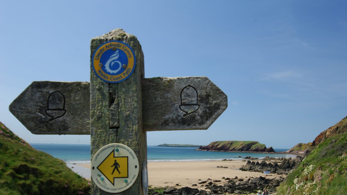
The marker for the start/finish point is just along the road from the Ferry Inn, St Dogmaels. The path then follows the road which is sometimes busy with no pavement. Passing the Teifi Waterside Hotel near Poppit which along with the Ferry Inn in St Dogmaels are popular spots for walkers celebrating completion of the Coast Path. Just after the hotel follow the off road route along a pavement and then through sand dunes for 932m to Poppit. For reasons lost in the mists of time, the official start/finish plaque was originally sited by the Poppit car park. Watch out for visiting wildfowl with views across the Teifi Estuary.
Walk difficulty: 1 out of 6 – Road with some gradients and flat section through sand dunes.
Car Park / Public Transport Access
Limited bus service to St Dogmaels and Poppit Sands from Cardigan and Fishguard. For more information see Pembrokeshire County Council website. Large National Park car park at Poppit Sands. For charging details click here. Pembrokeshire County Council car parks in St Dogmaels, for charging details click here. Seasonal parking at Allt-y-Goed campsite, the road is very narrow and unsuitable for large vehicles.
Facilities
Cardigan (Grid ref: SN177461)
Market town with a good range of services. Good bus links to Aberystwyth, Carmarthen and Haverfordwest. Start/finish of the Ceredigion Coast Path.
St Dogmaels (Grid ref: SN162460)
A large village with small shops, pubs and accommodation. The Coast Path starts at the slipway near the Ferry Inn.
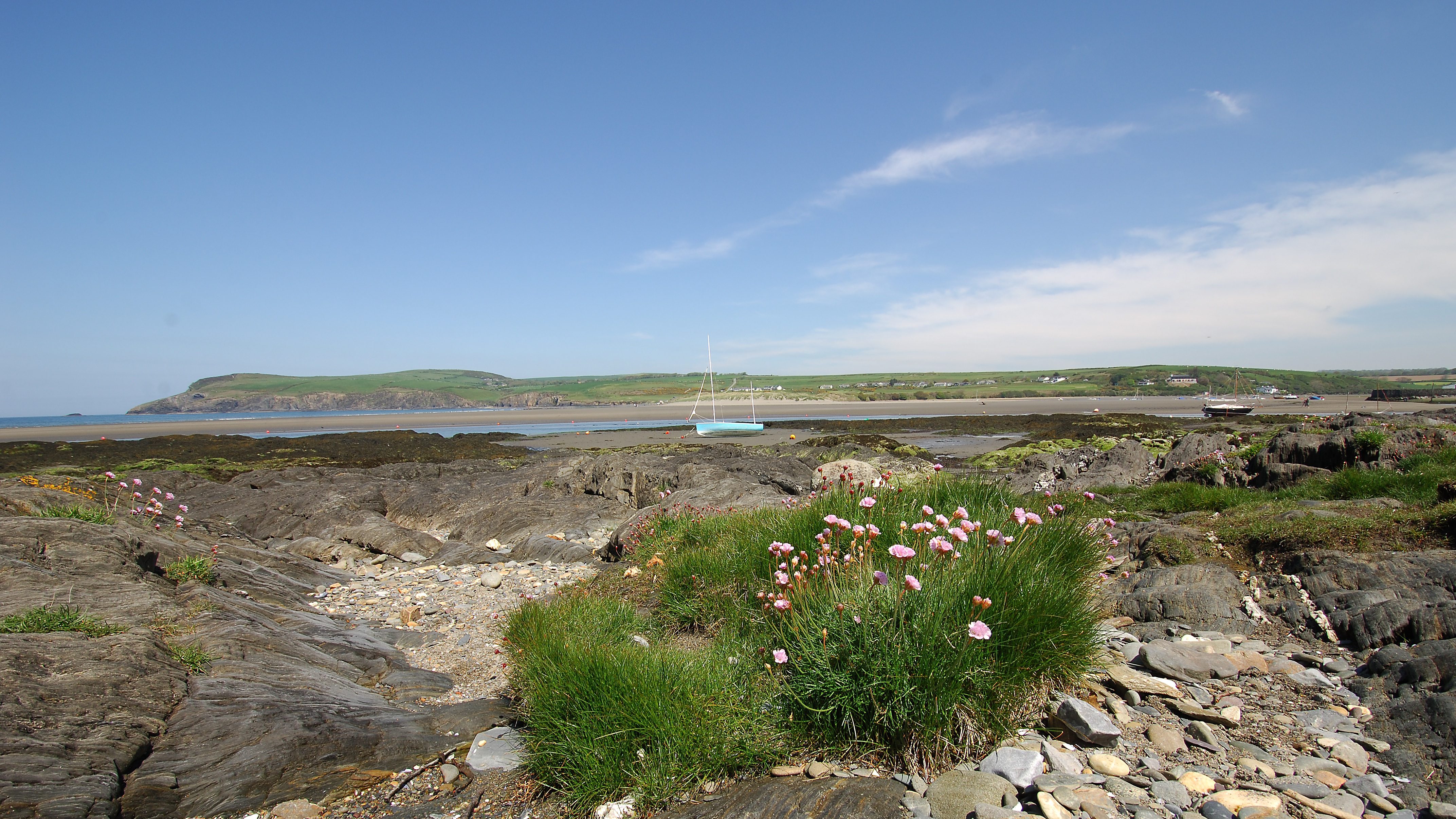
Poppit Sands Beach (Grid ref: SN151487)
Beach, cafe, radar WC and WC. Wheelchair access to large sandy beach with a blue flag award.
Worth a look
Poppit Sands Beach (Grid ref: SN151487)
This beach, at the mouth of the River Teifi, is a popular leisure spot. The dunes are important for wildlife, especially rare plants such as the bee orchid. National Park Authority staff manage over 20 hectares (50 acres) of dune, marsh and grazing land here. One of its projects is to turn the willow scrub behind the dunes back to reed bed. On the eastern side of the dunes, erosion has formed sand cliffs over four metres (13 feet) high. Take care near these, as they may collapse. New dunes are building up close to the access boardwalk.
2. Poppit Sands to Allt-y-goed cattle grid
1.3 Miles (2.1km)
Quiet, steep, single track road with good views. Joining paths give options for circular walks to inland.
Walk Difficulty: 2 out of 6. No man-made obstructions to wheelchairs, ground conditions vary.
Facilities
Poppit Sands YHA Youth Hostel (Grid ref: SN144488)
Walking Access Point
Four Footpaths linking to the wider inland area
Four joining paths give options for circular walks inland of varying lengths. At grid refs SN150484, SN147486, SN144487, SN141488.
Footpath to Cei-bach (Grid ref: SN143488)
Partly permissive footpath to small beach, also accessible from Poppit Sands at low tide.
Path to Cemaes Head (Grid ref: SN139490 and SN136492)
The first 150m or so is usually very wet and muddy. Starts as a bridleway but then footpath only to Pen Cemaes. Was originally the path to the Coastguard lookout building and makes a good circular walk.
3. Allt-y-goed cattle grid to Cemaes Head path – Inland Path Link
1.2 Miles (1.9km)
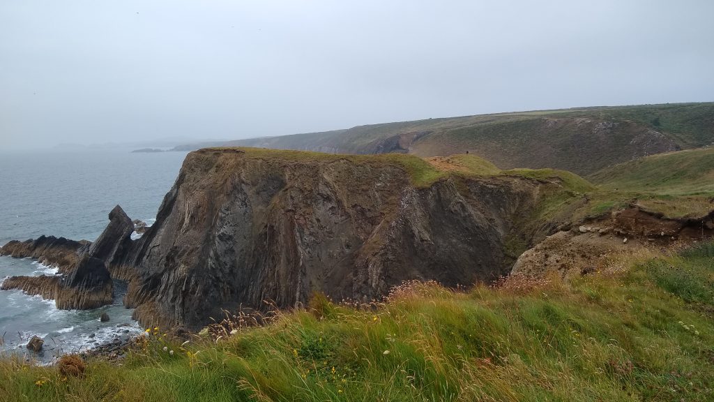
Cemaes Head is the most northerly of the many fine headlands on the Pembrokeshire Coast. Spectacularly faulted high cliffs with views across the mouth of the Teidi estuary towards Cardigan Island. The Headland is owned and managed by the Wildlife Trust of South and West Wales as a Nature Reserve. Pony’s graze the area for the benefit of the many bird to be found including Chough, Peregrines, Wheatear, Stonechar and Skylarks so please keep dogs on a lead. 1 stile with dog access (bypassed for a number of years), 9 gates, 22 steps, mostly gentle gradients. Horses graze on Cemaes Head.
Walk Difficulty: 5 out of 6 – flights of steps or steep hills, narrow cliff edge.
Caution
Cliff Edge
Eroding cliff edges for 380 metres near the Lookout. Keep to Path.
Walking Access Point
Cnwcau Footpath SN129490
Old Coastguard Lookout path joins offering a circular walk back towards Poppit. Follow the public footpath downhill until it joins a bridleway, keep straight on (don’t turn right) and it brings you to the road at Cnwcau (wet and muddy at the bottom).
Worth a look
Teifi Viewpoint
Good views across to Cardigan Island and of the estuary. Much of the headland is a nature reserve. Look out for guillemots, cormorants, fulmars and razorbills which nest on the cliffs in spring and early summer. You may also see the rare chough, feeding on the grassy slopes or performing its characteristic aerobatics. Cemaes Head is also a good spot to watch out for schools bottle-nosed dolphins and Porpoises.
Information
Pen Cemaes Lookout
Disused Coastguard lookout
4. Cemaes Head to Pwllygranant
1.1 Miles (1.8km)
High cliff path with spectacular views of sheer cliffs close up and Newport Bay in the distance. One pedestrian gate, steep descents and ascents from 574ft (175 metres) to near sea level.
Walk Difficulty: 6 out of 6 – steep gradients up to 1:1, exposed cliff top.
Caution
Path close to edge
Take care in windy weather. Quite long sections of Path fairly close to the cliff edge.
Pwllygranant Shore
Don’t be tempted to attempt the scramble to the shore here, the rocks are very slippery and steep.
Walking Access Point
Pwllygranant Footpath SN122478
A National Trust permissive footpath joins offering a circular walk back towards Poppit or Ceibwr links to a public footpath, rising steeply through a wooded valley. Turn left at either the lower footpath, or higher bridleway, junctions for a cross-country return to Poppit. Alternatively, climb up to the road and turn right then right at the next bridleway to return to Ceibwr. No room to park at the roadside (huge tractors turning).
Worth a look
Cemaes Geology
The geology of this section of coast is spectacular. The cliffs are made up of thin layers of sandstone alternating with mudstone. The layers were produced by underwater landslides, which swept sand from the coastal shelf into the mud of the deep sea-bed, around 440 million years ago in the late Ordovician period. Some 50 million years later, these layers were compressed by the collision of two continents, forming the remarkable folds visible in the cliffs between Cemaes Head and Ceibwr Bay. There’s a particularly good view of these folds from the western headland of Ceibwr Bay, looking back towards Cemaes Head.
5. Pwllygranant to Ceibwr
2 Miles (3km)
Open cliff with steep descents and ascents from 400ft to near sea level. Near Pencastell the Path has fewer hills, there is one stile on this stretch with provision for dog access. Sheep graze most of this section and sometimes ponies between Foel Hendre and Pencastell.
Walk Difficulty: 6 out of 6. Stiles, 11 steps, long steep gradients up to 1:1, exposed cliff top.
Caution
Cliff edge
Eroding cliff edges. Keep to Path. Take care in windy weather. Quite long sections of Path fairly close to the cliff edge.
Facilities
Penrallt Ceibwr
Take the footpath nearest Gaerwen and you can follow a steep wooded path to the tearooms and nursery.
Moylgrove
Moylgrove is 0.8 miles inland from Ceibwr. Bus stop with limited service between Cardigan and Fishguard. For more information click here. Small car park. WC. Small B&Bs and some self-catering options – book early.
Walking Access Point
Pencastell Bridleway
Circular routes join; above Pencastell follow the track northwards for a mostly off-road route to Poppit (or Pwllygranant).
Ceibwr Bridleway
Between Ceibwr and Pencastell follow the bridleway signs for a gentler route into the bay. Four public footpaths join the bridleway offering various circular walks.
Information
Pencastell
Pencastell (situated on private land) is the site of an Iron Age fort, one of 50 or so on the route of the Coast Path.
6. Ceibwr to Pwll-y-wrach (Top)
1.1 Miles (1.7km)
The Coast Path along this section has gentle gradients and, although the surface is uneven, there are neither stiles or steps. Just one short section of exposed rock slope and one wet patch where seeps have created a muddy area. This has not been drained for conservation reasons so is crossed by three stepping stones which can be bypassed in dry weather. Making this a splendid short section for the less mobile walker, one needs to be aware of the sudden drop to seaward. The Coast Path follows a minor road for about 43m at Ceibwr, then the route follows the southern bank of Ceibwr Bay before another 18m of minor road.
Walk Difficulty: 4 out of 6 – No stiles or flights of steps, gradients less than 1:6.
Caution
Cliff edge at Careg Wylan
Eroding cliff edges. Keep to path. Take care in windy weather. Some sections of Path fairly close to the cliff edge.
Car Park / Public Transport Access
Ceibwr
Roadside parking for about six cars. Bus stop at Moylgrove (0.8 miles inland) Limited service between Cardigan and Fishguard. For more information click here.
Information
Ceibwr Bay
Ceibwr Bay was once the port serving Moylegrove and the surrounding agricultural community, much of the land here is owned by the National Trust (not the area at the back of the beach). At the mouth of the stream is a ruined lime kiln. There are a number of benches and access to rocky beach. Seals likely between 1st August and end of November do not disturb them and keeps dogs on lead. The rocky cove of Ceibwr contains evidence of a more recent geological past. Cwm Trewyddel, the valley down which the Nant Ceibwr stream runs, was deepened by glacial meltwater in the Ice Age, and the lower part of the valley is partly blocked by glacial debris. The level platform near the base of the cove’s western headland is an ancient ‘raised beach’, with naturally cemented beach pebbles. This was formed about 125,000 years ago when the sea level was 5 metres (16 feet) higher than now.
Pwll-y-wrach
The Witches’ Cauldron (Pwll-y-Wrach), is a blow-hole caused by the collapse of a cave roof. A narrow passage connects it to the sea. The stream flowing down the nearby valley disappears underground and empties into the ‘cauldron’. On the opposite side of the valley is Castell Trerufydd, one of many Iron Age forts to be encountered along the Coast Path. No formal access to the beach, beware of undercut cliff and strong underground currents. Seals likely between 1st August and end of November do not disturb them and keeps dogs on lead.
7. Pwll-y-wrach to Newport Sands
6 Miles (9.66km)
A remote and challenging section with three stiles with provision for dogs to cross, 163 steps and many steep gradients. High cliff path with stunning views. Carpets of bluebells and orchids in late spring. Horses and sheep graze the coastal slopes above Cell Howell, near Blaenmeni and cattle near Treriffith.
Walk Difficulty: 6 out of 6. Stiles, long flights of steps, long and steep gradients up to 1:1, exposed cliff top.
Caution
Pen Pistyll
The tempting descent to the beach from the Pen Pistyll footbridge, although not very far, is not advised, being over almost vertical, slippery rocks.
High cliff
Eroding cliff edges. Keep to Path. Take care in windy weather. Some sections of Path fairly close to the cliff edge.
Car Park / Public Transport Access
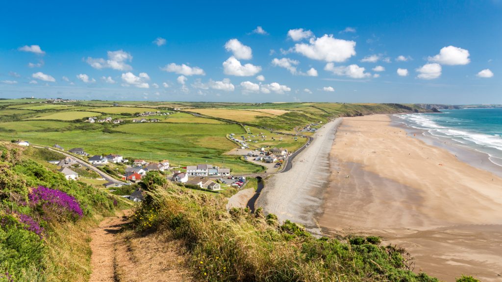
Newport Sands
Bus stop – limited service between Cardigan and Fishguard. For more information click here. Large National Park car park, for charging details click here.
Facilities
Newport Sands
Newport Sands Beach is gently sloping sandy bathing beach backed by dunes. Good cooling off spot after walking from Poppit!
Accessible WC. Refreshment kiosk in season. and café by the Golf Club
Walking Access Point
Castelltreruffydd Footpath SN100449
Junction with inland path. From the rapidly eroding Castell Treruffydd (Iron Age Fort), a steep, often muddy ascent through Fferm y Cadno to join the coast road. This is the only escape path between Ceibwr and Newport Sands.
8. Newport Sands to Newport Parrog
1.9 Miles (3km)
This section follows the banks of the river Nevern 1km or so inland to cross the river at the Iron Bridge. This is a shady walk through young woodland, the estuary is important for waders and wildfowl. The southern section of Path has a surface prepared for wheelchairs. The northern section has no introduced obstructions and in good weather may be passable by cross-country wheelchairs; this section is well used by families with pushchairs.
Walk Difficulty: No man-made obstructions to wheelchairs, ground conditions vary, one section approximately 10 metres close to cliff edge.
Caution Bryncyn SN062396
Tidal Crossing
A short length of this section is flooded on the highest spring tides. It is probably best to wait this out (about 1-2 hours), rather than walk the extra three miles on the road. The tide sometimes deposits piles of seaweed and debris here.
Car Park / Public Transport Access
Iron Bridge
Limited roadside parking (about eight cars), three seats.
Facilities
Newport Town
Newport has shops, hotels, pubs, post office etc and is about a quarter mile inland of the Coast Path. Newport is a fascinating little town. It was founded around 1200 as Novus Burgus, by William Fitzmartin, Lord of Cemaes. Its streets still follow the Norman grid pattern. The castle and lordship were fought over by the Normans and the Welsh, and changed hands several times. From the 16th century onwards, Newport was an important trading centre, exporting wool, herrings and slate and importing bricks, limestone, tiles and coal. Shipbuilding was another major industry. At the Parrog there were several cargo warehouses, one of which is now the Newport Boat Club. Nearby is a limekiln, where limestone was burned to produce lime for use in farming and building, and beside it the kiln-keeper’s cottage.
Walking Access Point
Newport Sands to Iron Bridge 1.4km
Park at Newport Sands car park. First section of Path crosses golf course so the surface is mostly short grass. The last 900m has a rolled stone surface which will re-vegetate in time, two gates with difficult latches. Most of the Path is level, or has gradients of less than 1 in 25 but there are four sections, each less than 50m long, with steeper gradients – all less than 1 in 8. During spring tides, occurring once a fortnight, the Iron Bridge end of the path is flooded at high tide. Nearest accessible toilets at Long Street car park, Newport. Easy Access 1.4km.
Iron Bridge to Newport Parrog
Newport Parrog SN 052397 to Iron Bridge SN 063395. From Newport Parrog car park, turn left back towards Newport, then left again onto the Coast Path. Purpose made rolled stone path to BT standard; cross fall is negligible. Path surface can flood in winter; repaired each spring. Although path predominantly level, it has slight gradients and is much used by cyclists. Landowner allows youngsters to ride horses on this path but such use is infrequent. Some seats, gate at east end. Toilets at Long Street car park, Newport. Wheelchair 1.1 km.
Information
Newport Sand Dunes
The dunes here suffered in the past from human trampling, but have been stabilised with marram grass planted by the National Park Authority.
Nevern Estuary
The sheltered estuary of the River Nevern is a favourite haunt of waders, ducks and seabirds. Look out for herons near the Iron Bridge. A Neolithic burial chamber, Carreg Coetan, stands just off the road leading from the bridge to Newport. A number of benches can be found along this route.
View this section on Street View
St Dogmaels (Grid ref: SN162460)
Follow the Coast Path Safety Code
- Take care on the Coast Path - it's rugged, natural terrain.
- Keep to the path, away from cliff edges and overhangs.
- Always supervise children, especially near cliff edges.
- Walking surfaces can vary considerably with the weather. Always wear strong footwear with a good grip and ankle support.
- Wear or carry warm and waterproof clothing.
- Cliff-top walking can be dangerous in high winds.
- Beware of taking shortcuts across beaches - you may be cut off by the tide. Swimming can also be dangerous.
- Do not sit under cliffs or climb them.
- Keep dogs under close control.
- The Coast Path is for walkers. It is not safe or lawful to ride horses or cycle along most of the Coast Path.
- Leave gates and property as you find them.
- Note that mobile phone coverage is unreliable on the coast.