This section is close to the accommodation, shops and amenities of St Davids and Solva. The many access points and a good bus service makes this a popular area for short and circular walks. There are now no stiles to cross between Porth y Dwfr (north of Whitesands) and Pembroke Dock.
1. Whitesands to St Justinian 2.2 Miles (3.22Km)
Quite low cliffs – up to 30m, good views of Ramsey Island. One gate, no stiles, 30 steps, gentle gradients.
Walk Difficulty: Stiles or flights of steps or steep hills
Car Park / Public Transport Access
Whitesands Car Park (Grid ref: SM734271)
Bus stop (Celtic Coaster – hourly Shuttle service around St David’s Peninsula). Large car park, but full up for much of the summer. Run by St Davids City Council, charge in season. WC.
Facilities
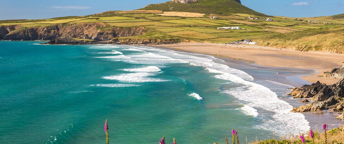
Whitesands
Cafe and shop.
Beach
Whitesands Beach (Grid ref: SM731271)
Popular surfing and bathing beach. Power boat trips to the Islands.
Caution
Whitesands Tides and Currents (Grid ref: SM731268)
It is possible to walk on the beach between Whitesands and Porthselau, but to do this safely a good understanding of the tides is needed. Swimmers should beware of the powerful currents if they swim too far out. Dog restrictions apply.
Walking Access Point
Whitesands Easy Access (Grid ref: SM733271)
Whitesands cross country wheelchair access. To the north, St Patrick’s Field is fairly flat for 150m before Path rises very steeply towards Penmaenddewi, wet in winter. To the south the Path rises more gently, but after 200m the surface is subject to water gullying and very rough, 5five seats. Both paths have sand surface. Toilets at car park. Easy Access Path 350m in total.
Walking Access Point
Whitesands South Footpath (Grid ref: SM733266)
0.5km south of Whitesands offers a short circular walk, (with road return) from Whitesands, or cross country footpath to St Davids.
Walking Access Point
Porthselau Footpaths (Grid ref: SM727259)
Two footpaths. One offers an inland return to Whitesands, partly along a sometimes muddy bridleway. The other is a track to the minor road, use this to make a circular walk via St Justinian or Porth Clais.
Beach
Porthselau Sand (Beach) (Grid ref: SM726260)
Small, sheltered beach much used by the nearby caravan / camp site.
Caution
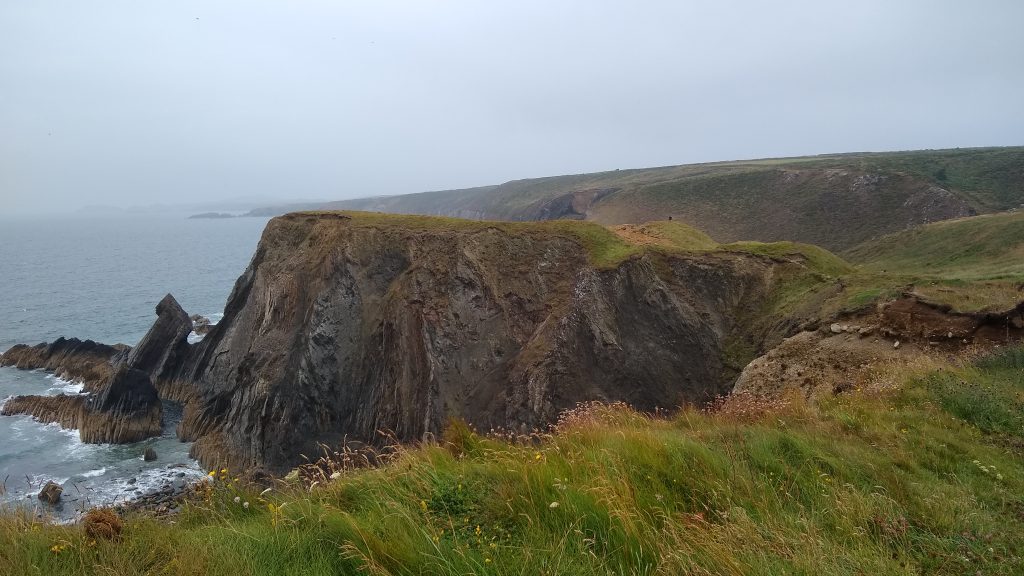
Unguarded Cliff Edge (Grid ref: SM721260)
Eroding cliff edges. Keep to Path. Take care in windy weather. Quite long sections of Path fairly close to the cliff edge.
2. St Justinian to Treginnis 0.7 Miles (1.61Km)
Cliff top plateau, the route of the Coast Path has very gentle gradients. Banks of thrift and other wild flowers in early summer, some sheer, solid looking cliffs. two kissing gates, one wicket gate, no stiles, three shallow stone steps. Sheep graze parts of this section.
Walk Difficulty: No stiles or flights of steps, gradients less than 1:6
Car Park / Public Transport Access
St Justinian Car Parking (Grid ref: SM724252)
Bus stop (Celtic Coaster – hourly Shuttle service around St David’s Peninsula). Car parking is very limited, the roads narrow. No WC.
Information
St Justinian (Grid ref: SM723252)
St Justinian is named after the 6th century saint who lived on Ramsey Island. Legend recounts that his followers, vexed by his strict regime, beheaded him, but he picked up his head and walked across to the mainland before dying. The ruined chapel, on private land, marks his original burial place. The lifeboat station was built in 1911 and, since then, lifeboats based here have saved countless lives. In summer there are boat trips from here to Ramsey Island, a nature reserve run by the Royal Society for Protection of Birds and an important stronghold for grey seals, choughs and seabirds.
Caution
Unguarded Cliff Edge (Grid ref: SM723252)
Unguarded cliff edge. Keep to Path. Take care in windy weather. Short sections of Path fairly close to the cliff edge.
Worth a look
Castell Heinif Iron Age Promontory Fort (Grid ref: SM723246)
An Iron Age promontory fort, one of over 50 Neolithic settlement sites to be found along the Pembrokeshire Coast Path National Trail.
3. Treginnis to Porth Clais 3.7 Miles (6.44Km)
Four short quite steep hills, including two that are a bit of a scramble. There is a long steep hill just west of Porth Clais. A wild section with a feeling of remoteness. Seven kissing gates, three wicket gates, no stiles, 25 steps. Sheep and horses graze parts of this section.
Walk Difficulty: Stiles, long flights of steps, gradients up to 1:1
Walking Access Point
Treginnis Footpath (Grid ref: SM722241)
Offers circular walks based on St Justinian or Porth Clais. Or a variety of loops and short cuts. There is no public parking on the roadside, farms or access tracks around Treginnis.
Information Ramsey Sound. Looking across towards Ramsey Island, you may see porpoises as well as seabirds such as gannets, kittiwakes and cormorants. They come here to feed on the plentiful fish brought to the surface by the rushing tides of the Sound, which can reach a speed of seven knots.
Caution
Strong current (Grid ref: SM716239)
No matter how hot you get, resist the temptation to swim in Ramsey Sound, the powerful current will whisk you off to Ireland!
Information
Penmaenmelyn Copper Mine (Grid ref: SM715235)
Fenced off mine shaft. In use during the 19th century.
Walking Access Point
Penmaenmelyn to Treginnis Footpath (Grid ref: SM715235)
National Trust permissive footpath. Offers circular walks based on St Justinian or Porth Clais, or a variety of loops and short cuts. There is no public parking on the roadside, farms or access tracks around Treginnis.
Caution
Sheep Trails (Grid ref: SM717231)
Mostly rounded cliffs to seaward – this area is grazed by sheep, so be cautious of following narrow contour paths that may go nowhere. If in doubt take the best defined more inland route.
Walking Access Point
Porth Henllys to Treginnis Footpath (Grid ref: SM725236)
National Trust Permissive footpath. Offers circular walks based on St Justinian or Porth Clais. Or a variety of loops and short cuts. There is no public parking on the roadside, farms or access tracks around Treginnis.
Walking Access Point
Porthlysgi to Treginnis Footpath (Grid ref: SM730237)
National Trust Permissive footpath. Offers circular walks based on St Justinian or Porth Clais. Or a variety of loops and short cuts. There is no public parking on the roadside, farms or access tracks around Treginnis.
Beach
Porthlysgi Beach (Grid ref: SM730236)
On a hot day Porthlysgi can be pleasant place to swim, the water is always bracing. Medium-sized remote beach with some sand. the eastern half gets cut off as the tide comes in.
Walking Access Point
Porthlysgi Farm Easy Access (Grid ref: SM737236)
This new permissive access from the farm may be passable by cross country wheelchairs.
4. Porth Clais to Caerbwdy 2.5 Miles (3.22Km)
Although there are steep hills at each end of this section, the Path has gentle gradients between. The section can be accessed from St Non’s or Caerfai to avoid the hills. No stiles, one kissing gate just east of St Non’s, one wicket gate, 15 steps just East of Porth Clais, five steps at Caerbwdy. Grand views open up across St Brides Bay to Skomer Island. Good changing perspectives as you walk around the S-bend of the bays.
Walk Difficulty: No stiles or flights of steps, gradients less than 1:6.
Walking Access Point
Treginnis Peninsula (Grid ref: SM740242)
Minor road, often very congested in the main season. Use the road to return to St Justinian or Porthselau, good short day peninsula walks. Also footpath return to St Davids / St Non’s.
Car Park / Public Transport Access
Porth Clais Bus Stop (Grid ref: SM740242)
Bus stop (Celtic Coaster – hourly Shuttle service around St David’s Peninsula). Free 20 car National Trust car park. Charged 15 car Harbour Trust car park. Small coffee / ice cream kiosk. Accessible WC.
Walking Access Point
Porth Clais Easy Access Path (Grid ref: SM740242)
The upper harbour sides are accessible – about 80m on each side. Surface is compacted stone. Views of picturesque little harbour. Seats. Radar WC at National Trust car park. 160m.
Information
Porth Clais (Grid ref: SM741241)
This narrow inlet was a valley carved out by glacial meltwater in the Ice Age and then flooded by rising sea levels as the ice retreated, 10,000 to 5,000 years ago. From the 16th century onward, this was a busy trading port. Limestone was shipped in and processed in the lime kilns by the harbour. The kilns and quay have been restored by the National Trust. According to tradition, St David was baptised here. Porth Clais also features in the Mabinogion, a medieval collection of Welsh legends, as the place where the giant boar Twrch Trwyth came ashore, pursued by King Arthur and his knights.
Caution
Red Wall – Climbers’ Paths (Grid ref: SM743238)
The sandstone slab cliffs provide training sites for local outdoor activity centres and cliff climbers, whose use has developed some distinct paths leading to the drop – if in doubt take the best defined more inland route.
Caution
Unguarded Cliff Edge (Grid ref: SM744239)
Eroding cliff edges. Keep to Path. Take care in windy weather. Short sections of Path fairly close to the cliff edge.
Information
St Non’s (Grid ref: SM751243)
This little bay, traditionally St David’s birthplace, is renowned for its magical atmosphere. The ruined chapel dates from around 1300 and is dedicated to David’s mother, St Non. The stones surrounding it may be the remains of a Bronze Age circle, a reminder of the legend that standing stones protected Non while she gave birth. A spring is said to have arisen on the spot where David was born, and has since become a holy well. The modern chapel and nearby St Non’s Retreat were built in the 1930s.
Walking Access Point
St Non’s Access (Grid ref: SM751242)
Two short footpath links to dead-end road with no formal parking.
Walking Access Point
Footpath Ffordd Aaron (Grid ref: SM752243)
St Non’s The eastern footpath, called Ffordd Aaron provides the shortest footpath link from the Coast Path to St David’s, (Stiles were removed from the route in 2006 making it easier for access) also offers field and green lane footpath return to Porthclais and (part-road) return to Caerfai.
Car Park / Public Transport Access
Caerfai Road Access (Grid ref: SM760243)
Minor road, small (25 car), free National Park car park, often very congested in the main season. Bus stop, main car park, cafe and WC are at the Visitor Centre 0.6 miles along the road.
Facilities
City of St Davids (Grid ref: SM753253)
Small city with a full range of services.
Car Park / Public Transport Access
Bus Stop and Visitor Centre (Grid ref: SM757252)
Bus stop (Celtic Coaster – hourly Shuttle service around St David’s Peninsula and Puffin Shuttle thrice daily return to Milford Haven) Catch the Strumble Shuttle at the Grove car park. Large National Park charged car park and the Authority’s Oriel y Parc Gallery and Visitor Centre. Accessible WC.
Beach
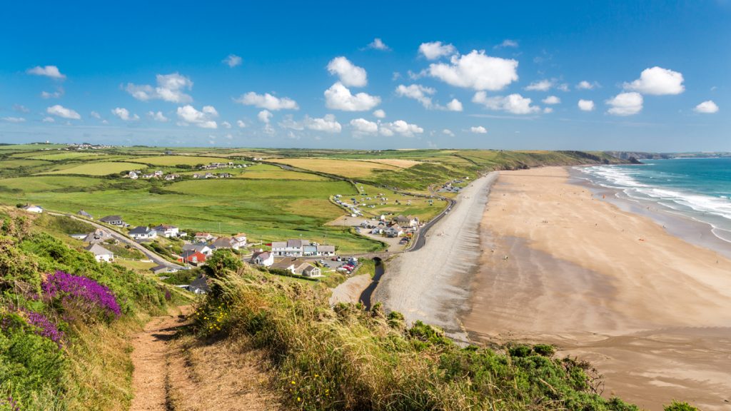
Caerfai Beach (Grid ref: SM760242)
The closest bathing beach to St Davids. A small to medium sandy beach with a steep descent nestles beneath high cliffs.
Caution
Caerbwdy and St Non’s Cliffs (Grid ref: SM762243)
Unguarded cliff edge. Eroding cliff edges. Keep to Path. Take care in windy weather. Some sections of Path fairly close to the cliff edge.
Worth a look
Penpleidiau Iron Age Promontory Fort (Grid ref: SM762240)
An Iron Age promontory fort, one of over 50 Neolithic settlement sites to be found along the Pembrokeshire Coast Path National Trail. Note the impressive triple ditches and banks dug in solid rock.
5. Caerbwdy to Porth y Rhaw 1.6 Miles (3.22km)
Steep hills at each end, this section can be accessed on paths with gentle gradients. A wide level path, set back from the cliff, on open common. 0 stiles, 1 wicket gate, 45 steps at Porth y Rhaw. Horses graze parts of this section.
Walk Difficulty: No stiles or flights of steps, gradients less than 1:6
Information
Caerbwdy Quarry
The purple sandstone (jasper) of Caerbwdy was laid down 540 million years ago in the Cambrian period. It was used in medieval times to build St David’s Cathedral. The quarry was recently re-opened to provide stone for restoration work.
Walking Access Point
Caerbwdy Footpath (Grid ref: SM767245)
Footpath access from a very small National Trust parking area 200m inland.
Beach
Caerbwdy Beach (Grid ref: SM766243)
A small to medium sand and boulder beach with interesting rock formations.
Walking Access Point
Trelerw Gentle Access Footpath (Grid ref: SM772243)
Short footpath links to minor road linking to main road, lay-by parking on main road. (Also links to Ffoss y Mynach.)
Walking Access Point
Foss y Mynach Footpath (Grid ref: SM776244)
Morfa Common (one mile west of Nine Wells A route called The Foss y Mynach joins. This route offers an option to walk the St David’s Peninsula as a two-day circular. The route is maintained by the National Park Authority, following public footpaths, bridleways and some minor roads to link with the Coast Path again at Penberry on the north coast of the St David’s Peninsula.
Walking Access Point
Nine Wells Gentle Access Footpath (Grid ref: SM784244)
The western (high) footpath to Nine Wells descends gently to the valley. Four car National Trust car park.
6. Porth y Rhaw to Lower Solva 1.8 Miles (3.22km)
Gentle gradients except for the steep hill at Solva that has 50 steps. The walk can be accessed on the fairly level footpath from Solva Post Office. Three wicket gates, no stiles, 50 steps.
Walk Difficulty: No stiles or flights of steps, gradients less than 1:6
Walking Access Point
Nine Wells Gentle Access Paths (Grid ref: SM786244)
Two footpaths offer either a high link to the main road or a low valley path with wetland interest. Standing for about four cars near the main road. These paths offer a very short loop with some good views, or a longer field edge circuit from Solva using National Trust permissive paths that are not shown on the maps, but well marked on the ground.
Beach
Porth y Rhaw Beach (Grid ref: SM785242)
A small shingle and rock beach with little sand. The access is quite steep.
Worth a look
Porth y Rhaw Iron Age Promontory Fort (Grid ref: SM786242)
A large Iron Age promontory fort, one of over 50 Neolithic settlement sites to be found along the Pembrokeshire Coast Path National Trail. This spectacular Scheduled Ancient Monument is best viewed from the western headland above.
Walking Access Point
Llanunwas Footpath (Grid ref: SM790239)
Level green lane links to the main road, no parking, no pavement. Bisects the field edge circuit from Solva on National Trust permissive paths that are not shown on the maps, but well marked on the ground.
Caution
Porth y Rhaw to Solva Cliffs (Grid ref: SM794237)
Unguarded cliff edge. Eroding cliff edges. Keep to the Path. Take care in windy weather. Short sections of Path fairly close to the cliff edge.
Walking Access Point
Upper Solva Footpath (Grid ref: SM794238)
Solva, Harbour High. Short footpath to minor road link to Upper Solva (little or no parking except at lay-by on main road).
Walking Access Point
Solva Quayside Wheelchair Path (Grid ref: SM805243)
Solva Quayside SM 805243 From Lower Solva car park to Yacht Club. Part smooth stone track, part asphalt, on unguarded sea wall. Gradients to Fieldfare standard; cross fall is negligible. Seats. Radar WC at car park. Wheelchair 0.8km.
Facilities
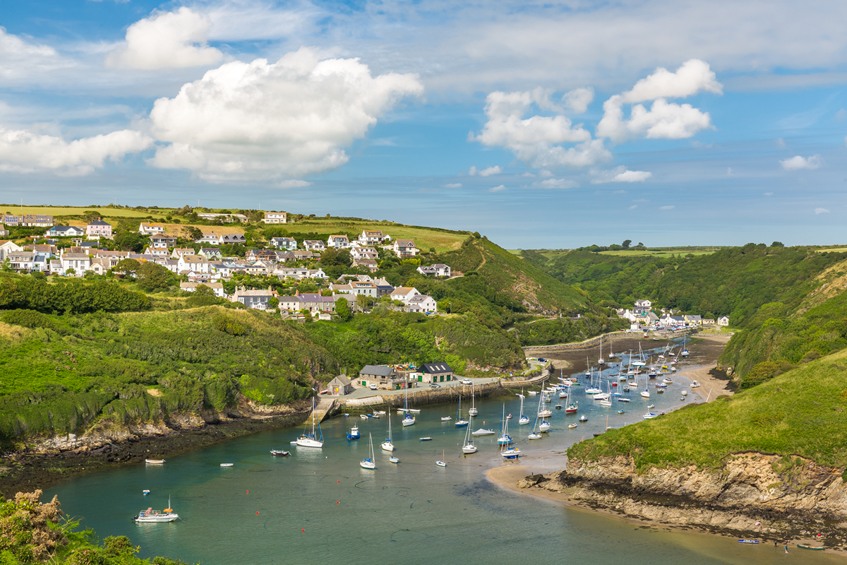
Solva (Grid ref: SM805243)
Solva Community Council Car Park (charges apply), village shops, accommodation, pubs.
Facilities
Harbour Inn (Grid ref: SM806243)
Beer and food with seats outside for the summer, a log fire for the winter.
Information
Solva (Grid ref: SM806244)
Solva, with its colourful cottages, shops and inns, is one of Pembrokeshire’s prettiest villages. Today it’s a popular boating centre but from the early 17th century it was a busy commercial port. By 1900, some 30 ships were registered here and there were nine warehouses for cargo. Limestone was shipped in and processed in the kilns. Trade declined after 1850, when the railway reached Pembrokeshire. The Solva valley and adjacent Gwadn valley were carved out by glacial meltwater during the Ice Age. When the ice retreated and the sea level rose, both valleys were flooded. The Gwadn has subsequently silted up. The valleys are separated by the knife-edged Gribin ridge, topped by an Iron Age fort.
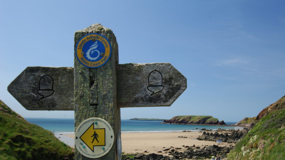
VIEW THIS SECTION ON STREET VIEW
Whitesands (Grid ref: SM734271)
Follow the Coast Path Safety Code
- Take care on the Coast Path - it's rugged, natural terrain.
- Keep to the path, away from cliff edges and overhangs.
- Always supervise children, especially near cliff edges.
- Walking surfaces can vary considerably with the weather. Always wear strong footwear with a good grip and ankle support.
- Wear or carry warm and waterproof clothing.
- Cliff-top walking can be dangerous in high winds.
- Beware of taking shortcuts across beaches - you may be cut off by the tide. Swimming can also be dangerous.
- Do not sit under cliffs or climb them.
- Keep dogs under close control.
- The Coast Path is for walkers. It is not safe or lawful to ride horses or cycle along most of the Coast Path.
- Leave gates and property as you find them.
- Note that mobile phone coverage is unreliable on the coast.