Section 14 (11 miles/17.7km). This section really typifies why this coast is worthy of National Park status. It contains Barafundle beach which has been voted one of the top ten beaches in the world! It also fringes the famous Lily Ponds at Bosherston which are a National Nature Reserve. The Path is quite undulating, but you're never far from a beach, village pub or toilet!
1. Broad Haven South to Stackpole Quay 3.1 Miles (4.83km)
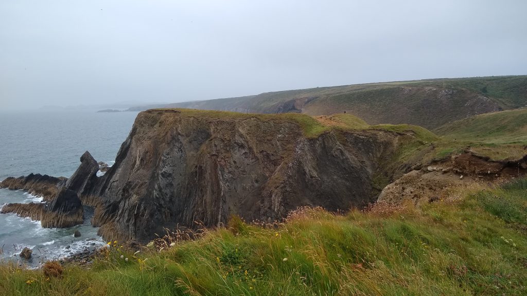
This stretch has four long flights of steps, wide and not steep. Total 173 steps, four kissing gates, one wicket gate, no stiles. Limestone cliffs at their best, blowholes, caves, arches etc. There are short cut paths across both Saddle Head and Stackpole Head. Razorbills and guillemots nest on the ledges, and choughs like this place; indeed, they are a common sight between West Angle Bay and Lydstep.
Walk Difficulty: Stiles or flights of steps or steep hills
Car Park / Public Transport Access
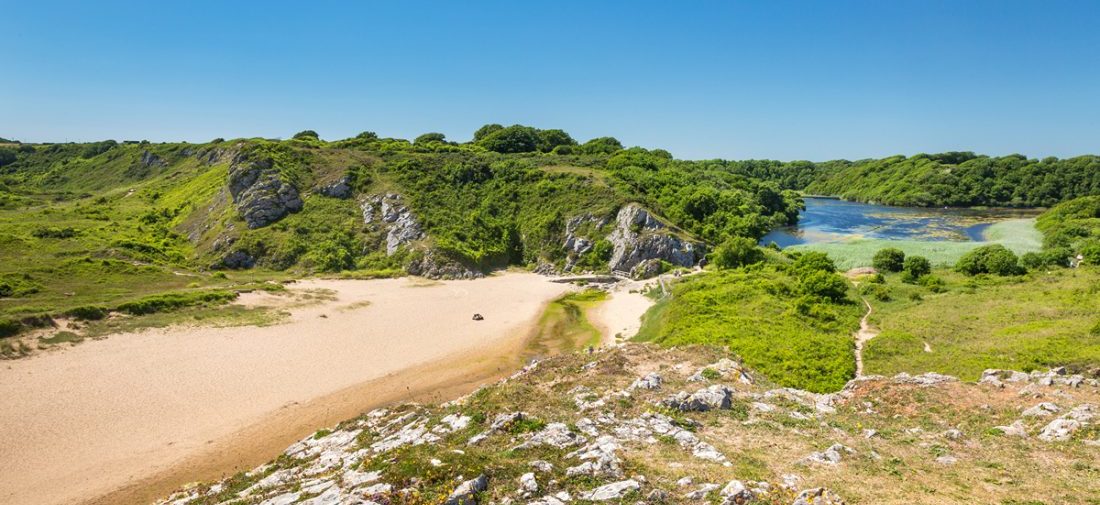
Broad Haven South (Grid ref: SR97559387)
Bus stop (Coastal Cruiser – thrice daily return – Pembroke – Freshwater East – Bosherston – Angle – Pembroke). Large, National Trust car park, charge in season. WC.
Beach
Broad Haven South Beach (Grid ref: SR97829396)
Large sandy beach backed by extensive dune system.
Caution
Stackpole Cliffs (Grid ref: SR98059402)
Beware of unguarded and eroding cliff edges. The cliffs look strong but the edges crumble! Beware of blowholes and sudden drops. The Coast Path is mostly well inland of the cliff.
Caution
Sandy Pit Beach (Grid ref: SR98299427)
Resist the temptation to try to get down to the first beach at Sandy Pit. The path has fallen away in places – this one is for rock climbers or boats only.
Worth a look
Stackpole Head (Grid ref: SR99549422)
This headland is a famous breeding ground for kittiwakes, razorbills, fulmars and guillemots. You may also see chough and puffins. There are a number of blowholes (collapsed cave roofs) through which the sea spouts on stormy days. Some of these were originally sea caves but others were cave systems formed by underground streams.
Beach
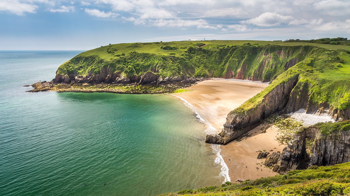
Barafundle Bay (Grid ref: SR99099504)
Large sandy beach backed by sand dunes. Easier to walk across barefoot! Broad Haven South is a pleasant spot for a swim, but Barafundle is idyllic, cool water that deepens quite quickly at some states of the tide. This was quite a quiet beach until it was voted the best beach in the multiverse! Now managed by the National Trust, it was formerly part of the Stackpole Estate. The steps down to the beach were once lined with ornamental columns and trees. The wall was built to keep deer inside the estate grounds. From the steps you can see a ‘smugglers’ cave’ in the cliff opposite. The natural arches on the southern headland are known as the Lattice Windows.
Caution
Stackpole Cliffs (Grid ref: SR99389558)
Beware of unguarded and eroding cliff edges. The cliffs look strong but the edges crumble! Beware of blowholes and sudden drops. The Coast Path is mostly well inland of the cliff.
2. Stackpole Quay to Freshwater East. 2.9 Miles (4.83km)
A demanding section with a series of steep hills, no stiles, two kissing gates, five wicket gates, 119 steps. Colourful Old Red Sandstone cliffs streaked with yellow algae. Views towards Manorbier and Stackpole Head limestone plateau.
Walk Difficulty: Long flights of steps, gradients up to 1:1
Car Park / Public Transport Access
Stackpole Quay Car Park (Grid ref: SR99139578)
Bus stop (Coastal Cruiser – thrice daily return – Pembroke – Freshwater East – Bosherston – Angle Pembroke), National Trust car park, charge in season. WC.
Walking Access Point
Eight Arch Bridge Path (Grid ref: SR99139578)
A permissive path joins here, offering a large circular walk via the Eight Arch Bridge and Stackpole Quay (1.7 miles). The Eight Arch Bridge and Stackpole Quay Section is owned privately – access is by permission and on occasions this path is closed.
Facilities
Stackpole Quay Tea Room (Grid ref: SR99249572)
Cream teas and lunches.
Information
Stackpole Quay (Grid ref: SR99329564)
The quay was built in the 18th century, to ship out limestone from the nearby quarry and bring in luxury goods for Stackpole Court. The National Trust has converted the nearby farm buildings into holiday cottages, while the quarry is now used for outdoor educational activities. The small offshore island shows a spectacular fold in the layers of Carboniferous Limestone, caused by continents colliding 290 million years ago. In the next bay, the limestone gives way to the multicoloured mudstones, siltstones and sandstones of the Old Red Sandstone. From the bay’s northern headland you can see the impressive profile of Greenala Point. Here the multi-coloured rock layers are covered with bright orange Xanthoria lichens.
Worth a look
Greenala Iron Age Promontory Fort (Grid ref: SR00679657)
Here the Coast Path passes through the outer ramparts of a large Iron Age fort. Two banks and ditches protect the headland, though it is likely that most of the inhabitants lived outside the walls and retreated inside only in times of danger.
3. Freshwater East Beach 0.7 Miles (1.61km)
A long beach backed by extensive sand dunes. The route of the Coast Path is behind the first rank of dunes, but many walkers use the beach when the tide is partly out. The ascent from the beach at the north east end is a short scramble just before the cliffs start to rise. Use the slipway at the south end. A steep hill with 51 steps connects the sand dune path with the upper cliff path to/from Manorbier.
Walk Difficulty: No stiles or flights of steps, gradients less than 1:6
Car Park / Public Transport Access
Freshwater East Car Park (Grid ref: SS01589775)
Bus stop at the beach access (Coastal Cruiser – thrice daily return – Pembroke-Freshwater East-Bosherston-Angle-Pembroke). Large National Park car park, charge in season. WC on path to beach.
Walking Access Point
Freshwater East Beach Access (Grid ref: SS01589776)
Freshwater East Beach access and viewpoint. SS 015977 short boardwalk/rolled stone surfaced path to viewpoint overlooking beach, joins similar path to beach. Wheelchair 160m.
Beach
Freshwater East Beach (Grid ref: SS01939788)
Big popular sandy beach backed by extensive sand dunes.
Walking Access Point
Freshwater East Footpaths (Grid ref: SS01929807)
GR SS 019980 to SS 025983 some half dozen footpaths join and cross the Coast Path, most were recently registered as public and not shown as such on most maps. These paths link the village with the beach. The easternmost high path (permissive link) is partly surfaced, offering wheelchair access to a viewpoint and an access to the Coast Path that avoids the very steep hill from the dunes (also the easiest route to and from the pub).
Information
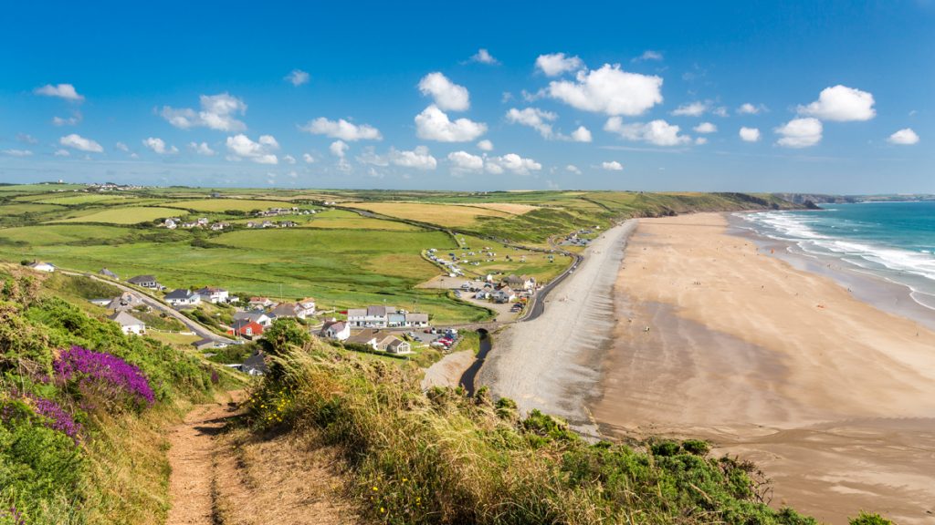
Freshwater East (Grid ref: SS01619803)
This superb sandy beach has long been a popular leisure spot, and in past centuries was a favourite haunt of smugglers. On one side of the bay is a holiday village built in the 1970s under the then-prevailing policy of allowing a few places to develop as ‘honeypot’ resorts. The dunes have been extensively restored and replanted to counter the effects of human trampling, and there are pathways through them to the beach. The National Park is developing a management plan for the dunes and scrub woodland, to improve opportunities for wildlife and for public access. The dunes are a particularly good place to see glow-worms, if you’re here at dusk.
Facilities
Freshwater East Village (Grid ref: SS02029840)
B&B. No shops. Freshwater Inn.
4. Freshwater East to Manorbier 3.4 Miles (4.83km)
Level sections at each end, short quite steep hills between. No stiles, 10 wicket gates, six steps.
Walk Difficulty: Stiles, long flights of steps, gradients up to 1:1
Car Park / Public Transport Access
Freshwater East – East Car Park (Grid ref: SS02409838)
Small free car park at east boundary of village.
Walking Access Point
East of Freshwater East (Grid ref: SS02469822)
East of Freshwater East SS023983. From small formal parking area just before the speed limit signs towards the cliff top, with views of Trewent and the bay. Asphalt path to Fieldfare standard. Beware – the path ends on the crest of a steep slope. Seats. Toilets at Freshwater East, on beach access path. Wheelchair 220m.
Walking Access Point
West Moor Footpath (Grid ref: SS04259820)
West Moor, Swan Lake. Cross-field and farm track link to the minor coast road, tearoom at the farm. This path offers an inland return to Freshwater East along roads – after 150m of the B4139 turn left (this road is very, very minor).
Facilities
West Moor Tea Rooms (Grid ref: SS04129849)
Seasonal.
Walking Access Point
East Moor Footpath (Grid ref: SS04609804)
East Moor, Swan Lake: This field-edge footpath links to the minor coast road, to make a short circular walk from Manorbier.
Beach
Swan Lake Beach (Grid ref: SS04539795)
Medium-sized sand/gravel beach. (No swans, no lakes). A lovely secluded beach for a dip, the particular wave action sorts the small stones into drifts of the same sized pebbles.
Caution Old Red Sandstone cliffs. The Old Red Sandstone cliffs are vertically faulted and the sea has exploited week points to develop very deep fissures on the headlands – keep to the waymarked route and supervise children and dogs closely on this section.
Car Park / Public Transport Access
Manorbier Parking (Grid ref: SS05999767)
Limited roadside parking with a view. A good spot in winter storms.
5. Manorbier to Skrinkle Haven 1.7 Miles (3.22km)
There are three short steep hills (two are stepped) and a long steady hill west of Presipe. East of Presipe is quite flat but there are two stiles (near Skrinkle), four wicket gates, 50 steps. The stile (at the NW corner of the rocket range fence) has no provision for dog access. A sudden wild and remote feeling to this section between Presipe and Manorbier headland (Priest’s Nose). Grand views of the Bay and across towards Stackpole, then towards the Range and Caldey Island.
Walk Difficulty: Stiles, long flights of steps, gradients up to 1:1
Information
Manorbier Youth Hostel (Grid ref: SS08009763)
The Manorbier YHA is at Skrinkle Haven, not Manorbier.
Worth a look
Manorbier Castle (Grid ref: SS06399778)
Manorbier was the home of the great 12th century churchman, traveller and writer Giraldus Cambrensis (Gerald of Wales). One of his books, The Journey Through Wales, is still in print today. The castle, where he was born, is perched on a spur of rock with streams on either side. The north-western stream was dammed to create fishponds and mill leats. The oldest part of the castle, overlooking the beach, dates from the 12th century and was built by Gerald’s family, the de Barris, who lived here until 1336. Described by Gerald as ‘the pleasantest spot in Wales’, the village is a perfect example of a Norman manor, complete with church, mill and dovecote.
Facilities
Manorbier Village (Grid ref: SS06719788)
Manorbier village for pub, shop, B&B.
Car Park / Public Transport Access
Manorbier Car Park (Grid ref: SS06249768)
Large National Park car park, charge in season (and ice cream van). WC in the car park.
Walking Access Point
Manorbier Beach Wheelchair Path (Grid ref: SS06189766)
Manorbier beach access. From main beach car park below castle a gravel surfaced path leads to beach. To BT standard, last section is over a timber boardwalk, ending at a seat. Views of beach and castle. Beach itself is soft sand. Toilets in car park. Wheelchair 210m.
Beach
Manorbier Beach (Grid ref: SS06019748)
Medium sandy beach, popular with surfers.
Caution
Old Red Sandstone Cliffs (Grid ref: SS05909723)
The Old Red Sandstone cliffs are vertically faulted and the sea has exploited weak points to develop very deep fissures right up to the Path on the approaches to the headlands – keep to the waymarked route and supervise children and dogs closely on this section.
Walking Access Point
King’s Quoit Footpath (Grid ref: SS05999733)
King’s Quoit/Parson’s Piece and SS05959712. These two junctions with the same path offer 0.6 mile circuits with fine views via the Medieval church. Watch out for the very deep sudden fissures 120 feet deep.
Worth a look
King’s Quoit (Grid ref: SS05939728)
South-east of the beach, the Coast Path passes the King’s Quoit, a Neolithic burial chamber dating from around 3,000 BC.
Caution
Manorbier Cliffs (Grid ref: SS06119710)
Unguarded cliff edges. Narrow path. Keep to Path. Take care in windy weather. Quite long sections of Path fairly close to the cliff edge.
Beach
Presipe Beach (Grid ref: SS06949698)
Medium sandy beach. The descent to Presipe Beach is very steep, with many steps. This is a secluded beach, take care, as the beach bed has deep hollows.
Walking Access Point
Hill Farm Footpath (Grid ref: SS06949709)
Presipe A path crosses from Hill Farm to Presipe Beach, the beach access is very steep. This Path presents the option for a circuit from Manorbier (0.7 miles to the village).
Information
Skrinkle Missile Range (Grid ref: SS07399677)
The MOD Range ahead is one where they fire guided missiles towards targets towed by model planes; if you hear a faint drone of a plane circling out to sea, be prepared for a very loud double bang.
Information
Conigar Pit Footpath (Grid ref: SS07279702)
Maps show a path heading towards Conigar Pit – this goes nowhere, as the remainder was extinguished when the Range was built.
Information
Skrinkle Old Path (Grid ref: SS07469755)
The path shown on most maps just north of the Skrinkle camp gates as Coast Path is an old route of the Pembrokeshire Coast Path. This path now goes to the playground further north.
VIEW THIS SECTION ON STREET VIEW
Broad Haven South (Grid ref: SR975938)
Follow the Coast Path Safety Code
- Take care on the Coast Path - it's rugged, natural terrain.
- Keep to the path, away from cliff edges and overhangs.
- Always supervise children, especially near cliff edges.
- Walking surfaces can vary considerably with the weather. Always wear strong footwear with a good grip and ankle support.
- Wear or carry warm and waterproof clothing.
- Cliff-top walking can be dangerous in high winds.
- Beware of taking shortcuts across beaches - you may be cut off by the tide. Swimming can also be dangerous.
- Do not sit under cliffs or climb them.
- Keep dogs under close control.
- The Coast Path is for walkers. It is not safe or lawful to ride horses or cycle along most of the Coast Path.
- Leave gates and property as you find them.
- Note that mobile phone coverage is unreliable on the coast.