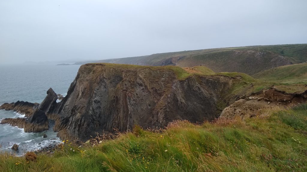
An exhilarating, and in places, rugged section of Path above high cliffs and beneath the dramatic craggy volcanic outcrops of Pen Beri, Carn Lleithyr and Carn Llidi. Make time to linger on the wild and rocky peninsular of St David's Head which abounds with archaeology. Keep an eye out too, for seals in the rocky coves below the Path and gannets diving for fish out to sea; you may be lucky enough to see the grey dorsal fins of porpoises hunting for fish beneath the gannets. The section between Abereiddi and Whitesands feels wild and remote with hardly a building to be seen, making the cafe at Whitesands or the refreshment van at Abereiddi, if walking south to north, welcome sights for the weary walker!
1. Porthgain to Abereiddi 2 miles (3.2km)
Once on the cliff top plateau, the route of the Coast Path has very gentle gradients; the steep fight of 66 concrete steps at Porthgain may be avoided by using the Ynys Faen footpath. The slope above Abereiddi is steep, although the western few hundred yards shares the route of a surfaced wheelchair path to the Blue Lagoon. No stiles, four gates, 66 steps (Grade 2, if using the footpath to avoid the Porthgain steps). Sheep and horses graze parts of this section.
Walk Difficulty: Stiles or flights of steps or steep hills.
Car Park / Public Transport Access
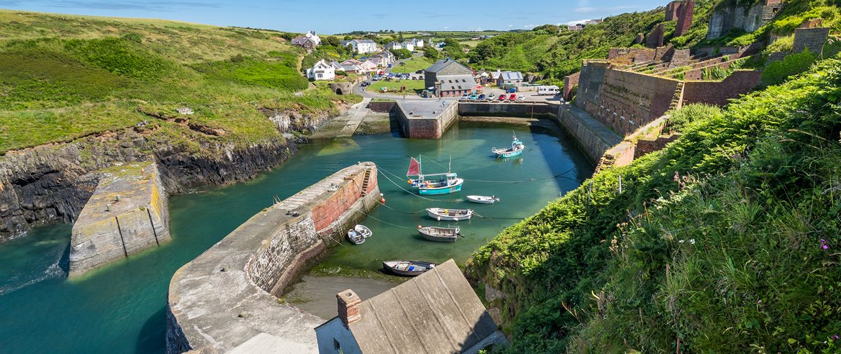
Porthgain (Grid ref: SM813323)
Bus stop (Strumble Shuttle – thrice daily return – St David’s to Fishguard). Medium-size, free National Park car park, often full. WC.
Walking Access Point
Porthgain Quarry Easy Access (Grid ref: SM815324)
From the car park go back up the road towards Llanrhian and turn right after the terrace of little cottages up a steep grassy slope (soft when damp) and around the big house [Ynys Faen] (some adverse camber on a bend) follow the footpath through two accessible gates (the second is tight for a Tramper off-road wheelchair, but doable) and up onto the cliff. Access is possible towards Abereiddi but you need to pick your route across sections of rough ground. Access is also possible down the old incline to the granite quarry near Porthgain. Spectacular views towards St David’s Head and Strumble Head. No seats. Toilets at Porthgain. Also a very nice pub, but it is inaccessible, although they say that they will carry people up the steps, or serve on the grass or car park below. Easy Access Path up to 2km depending on cross country capability.
Caution
Unguarded Cliff Edge. (Grid ref: SM812326)
Unguarded cliff edge. Keep to Path. Take care in windy weather. Although there is plenty of room to stay away from the cliff on this section, the cliffs are sheer.
Information
Porthgain Industry (Grid ref: SM812325)
In the 19th and early 20th centuries, Porthgain was a thriving industrial port. The local stone, a hard igneous rock known as diorite, was quarried for use as a building stone and for surfacing roads. Crushed and graded, it was stored in the great hoppers which still loom over the harbour, before being exported by sea. There was also a brickworks which used local clay, and much of the slate quarried at Abereiddi was shipped from here. Trade declined after World War I and the stoneworks finally closed in 1932. The National Park Authority is now responsible for conserving the harbour and industrial remains. The Row, a terrace of cottages on the west side of the village, was recently re-roofed using Abereiddi slates recovered from a cargo which had sunk in the 19th century.
Information
Coastal Grazing (Grid ref: SM802321)
This section is owned by the National Trust, one of the many coastal sections where grazing is being reintroduced to improve the habitat diversity.
Beach
Traeth Llyfn Beach (Grid ref: SM801320)
Wide sandy beach with a 90 foot steel staircase for access. Access is cut off at the top of spring tides. Despite its remote location this is a very popular beach.
Walking Access Point
Traeth Llyfn Footpath (Grid ref: SM801317)
Offers a short circular walk from Abereiddi.
Caution
Sheer Cliff Edges (Grid ref: SM795314)
Beware of standing too close to the edge viewing the Blue Lagoon.
Walking Access Point
Blue Lagoon Easy Access (Grid ref: SM797314)
Abereiddi – Blue Lagoon, part concrete, part hard earth and rock path leading to low viewpoint across stunning Blue Lagoon – a deep flooded quarry. Steepest gradient is 1:8 on rough concrete – two 5m sections, 1:10 for 50m on concrete, but also a stone section at 1:15 for 60m. Cross fall is negligible. One seat. The car park has a very rough surface, especially after winter storms. Toilets at Porthgain.
Information
Abereiddi Industry (Grid ref: SM796313)
Slate was quarried at Abereiddi even before the development of Porthgain. At first, the slate was loaded on to ships alongside the quarry, though later it was taken by tramway to Porthgain. The old quarry, now flooded, is known as the Blue Lagoon and is connected to the sea by a narrow channel. Further along are the remains of quarry buildings and slate-workers’ cottages. A section of Path suitable for wheelchairs links the Blue Lagoon to the car park. Near the road are some fine traditional cottages. Many have grouted roofs, with the slates held down by rope or barbed wire and covered with cement wash. This traditional method of protection from storm damage was once widespread in Pembrokeshire, but grouted roofs are now a rarity. Abereiddi and its environs are managed by the National Trust.
2. Abereiddi to the east side of Aber-pwll 1.3 Miles (1.61km)
Two quite steep hills, otherwise fairly even gradients, with sheer, crumbling cliffs to seaward. Sheep graze parts of this section. No stiles, five gates, 10 steps. The section near Abereiddi is on a narrow road with no pavement (400m).
Walk Difficulty: Stiles or flights of steps or steep hills
Car Park / Public Transport Access
Abereiddi Car Park (Grid ref: SM796313)
Bus stop (Strumble Shuttle – thrice daily return – St David’s to Fishguard). Privately-owned car park that is shrinking as 2014 winter storms removed the sea defences; roughly surfaced and often very rough during the winter from storm damage. WC. Seasonal ice cream van.
Beach
Abereiddi Beach (Grid ref: SM796312)
Medium sand and shingle beach. Very popular with coasteering groups and fossil hunters. Geologists – please do not hammer the outcropping rocks for fossils.
Caution
Eroding cliff edges. (Grid ref: SM795309)
Eroding cliff edges. Keep to Path. Take care in windy weather. Quite long sections of Path fairly close to the cliff edge.
Information
Iron Age Settlement of Caerau. (Grid ref: SM788307)
The Coast Path passes through the Iron Age settlement complex of Caerau. A Scheduled Ancient Monument with dramatic ditches and banks.
Walking Access Point
Aber Pwll (Grid ref: SM785306)
Offers a farmland circular walk from Abereiddi.
3. Aber-pwll to Porth y Dwfr 2.2 Miles (3.22km)
A rugged, challenging and wild section. In places the path surface is a rock scramble, including the route down to and up from the charming cove of Aber-pwll. Five stiles, 54 steps, two kissing gates, five wicket gates. Sheep, cattle and horses graze parts of this section.
Walk Difficulty: Stiles, long flights of steps, gradients up to 1:1.
Caution
Rocky Slopes. (Grid ref: SM784305)
Some steep rocky slopes – take particular care in wet weather.
Beach
Aber-pwll Beach (Grid ref: SM784305)
Small secluded rocky cove, the sort of place where two people seem like a crowd.
Information
Castell Coch (Grid ref: SM775302)
One of three Castell Cochs – yet another Iron Age fort. in late summer and autumn the inaccessible beaches below are popular nurseries for seal pups.
Walking Access Point
Ffos y Mynach Footpath (Grid ref: SM764292)
A route called The Ffos y Mynach joins here. Firstly, this offers an option to lunch on the top of Carn Penberry with all of West Pembrokeshire laid out before you. Secondly, this route offers an option to walk the St David’s Peninsula as a two-day circular. The route is maintained by the National Park Authority, following public footpaths, bridleways and some minor roads to link with the Coast Path again one mile west of Nine Wells. Thirdly, use this footpath to make a short day circular walk based on Whitesands. Note the contrast between the modern farming practices of the inland lowlands with the Medieval village farmsteads that you walk through, Dark Ages at Maes y Mynydd and the Iron Age near St David’s Head.
Information
Carn Penberry (Grid ref: SM766292)
Penberry is the first in a sequence of dramatic rocky tors along the northern coast of the St Davids peninsula. The others are Carn Treliwyd, Carn Perfedd, Carnedd Lleithr and Carn Llidi. These tors are formed of hard igneous rock. About 70 million years ago, when the sea-level was much higher, they were islands. The sea which surrounded them wore away the softer rocks to create the plateau that now covers much of Pembrokeshire.
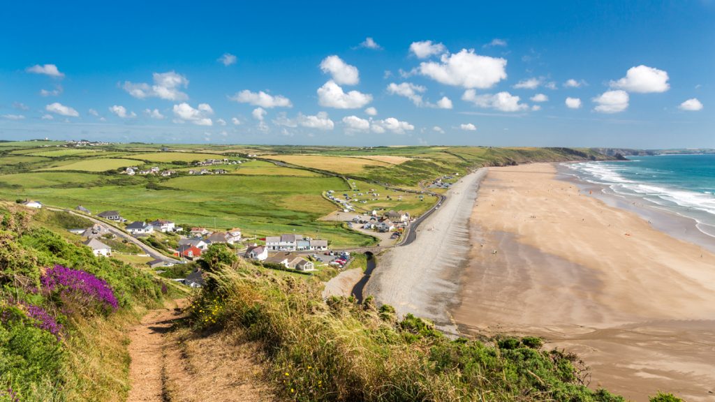
4. Porth y Dwfr to Whitesands 3.9 Miles (6.44km)
Wild open views, mountain type vegetation on the mostly rounded cliffs of volcanic origin. The steepest gradient on this section is the descent to Whitesands, the rest is gentler, but in places the surface is rough. No stiles, six gates, 77 steps. Sheep, cattle and horses graze parts of this section.
Walk Difficulty: Stiles or flights of steps or steep hills
Walking Access Point
Porth Gwyn Footpath (Grid ref: SM749287)
National Trust permissive footpaths. These two steep paths offer options to divert to a high level route around Carnedd Lleithr, or take short cuts to St Davids avoiding St David’s Head.
Walking Access Point
Porth Coch Footpath (Grid ref: SM743287)
National Trust permissive footpaths. These two steep paths offer options to divert to a high level route around Carnedd Lleithr, or take short cuts to St David’s avoiding St David’s Head.
Walking Access Point
Dar y Cadno (Grid ref: SM736287)
National Trust permissive footpath. This steep and rough path offers an option to divert to a high level route, taking in the views from Carn Llidi. Shortest route to St Davids YHA.
Facilities
St Davids Youth Hostel (Grid ref: SM740277)
The Youth Hostel nestles beneath Carn Llidi and is 0.9 miles from the Coast Path, two miles from St David’s.
Walking Access Point
St David’s Head Footpaths (Grid ref: SM729283)
Many footpaths crisscross St David’s Head giving a number of choices for circular walks.
Information
St David’s Head (Grid ref: SM722279)
The end of the headland lies within an Iron Age fort. Traces remain of three parallel stone ramparts and the foundations of six roundhouses. To the east, you can see the low boundaries of a field system which may date from the same period. A much earlier human presence is represented by Coetan Arthur, a Neolithic burial chamber dating from 4,000 to 3,000 BC. The stone slabs would have been covered with earth, which has long since worn away. The lowland heath in this area is now an internationally-rare habitat, which conservation organisations are working to protect.
Beach
Porthmelgan Beach (Grid ref: SM727728)
A small to medium sandy beach. A quiet and pleasant spot to cool off before busy Whitesands. Beware of powerful currents offshore!
Caution
Unguarded Cliff Edge (Grid ref: SM732274)
Eroding cliff edges. Keep to Path. Take care in windy weather. Quite long sections of Path fairly close to the cliff edge.
Information
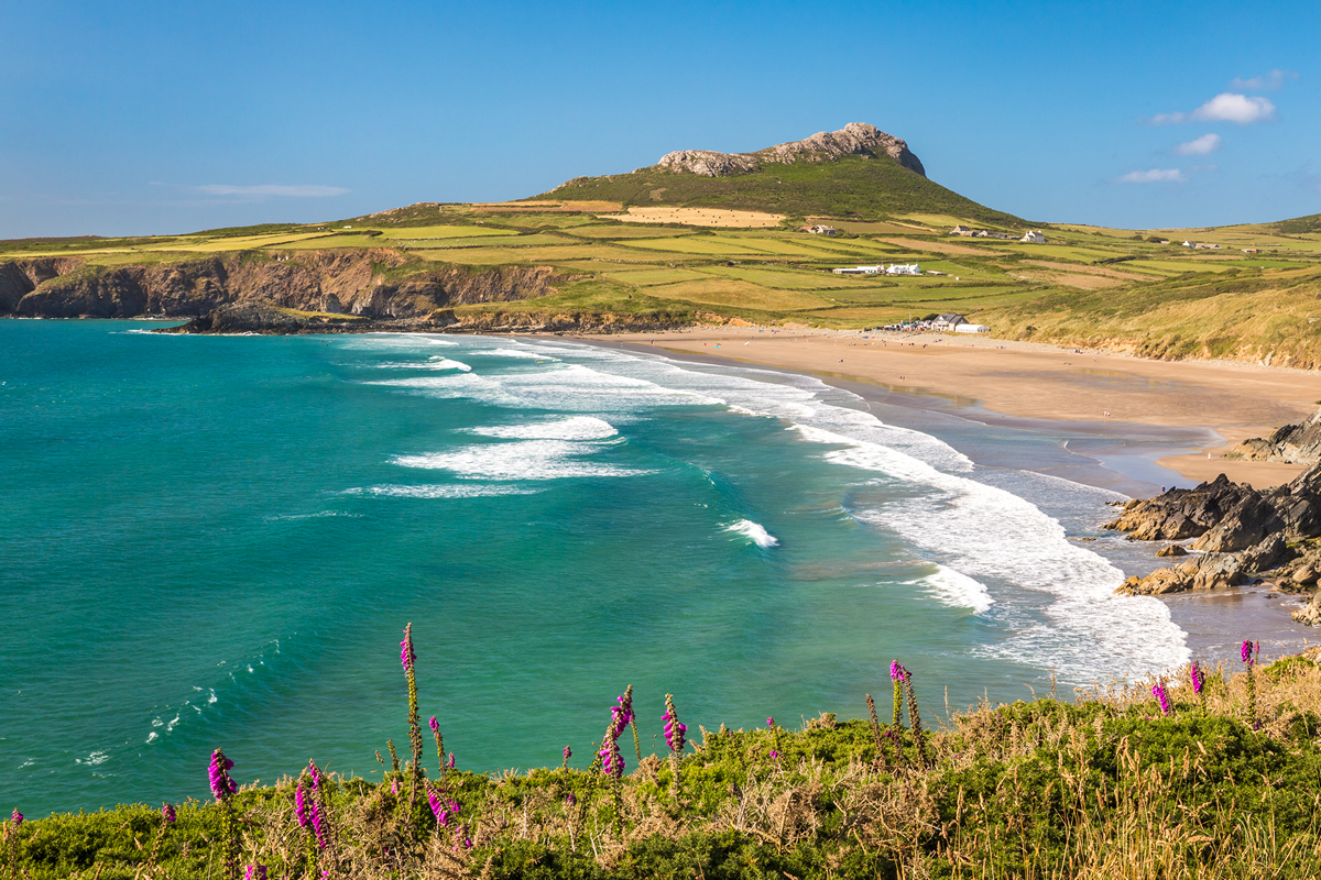
Whitesands Bay (Grid ref: SM733272)
Today, the beach at Whitesands is popular with holidaymakers and surfers. From the Bronze Age onwards it was the meeting point for land and sea routes to Ireland, used by traders, travellers, pilgrims and saints. Traces of a 6th century chapel to St Patrick are buried beneath the dunes at the north end of the beach. The dunes extend for some distance inland and have been restored by the National Park Authority.
View this Section on Street View
Porthgain (Grid ref: SM815324)
Follow the Coast Path Safety Code
- Take care on the Coast Path - it's rugged, natural terrain.
- Keep to the path, away from cliff edges and overhangs.
- Always supervise children, especially near cliff edges.
- Walking surfaces can vary considerably with the weather. Always wear strong footwear with a good grip and ankle support.
- Wear or carry warm and waterproof clothing.
- Cliff-top walking can be dangerous in high winds.
- Beware of taking shortcuts across beaches - you may be cut off by the tide. Swimming can also be dangerous.
- Do not sit under cliffs or climb them.
- Keep dogs under close control.
- The Coast Path is for walkers. It is not safe or lawful to ride horses or cycle along most of the Coast Path.
- Leave gates and property as you find them.
- Note that mobile phone coverage is unreliable on the coast.