Strikingly red low cliffs. Coastal slopes and cliff tops rich in wildflowers. In places the red of the Old Red Sandstone is brightly streaked with yellow algae. There are now no stiles on this section.
1. Broad Haven to Little Haven 1 Miles (1.61km)
The designated route is along the road. This is wide with a pavement through Broad Haven. But narrow with no pavement between Little Haven and Broad Haven. Many people use the beach at low tide. There is a danger of being cut off – knowledge of the tides is needed.
Walk Difficulty – Road.
Facilities
Broad Haven Youth Hostel (Grid ref: SM862140)
Car Park / Public Transport Access
Broad Haven North Car Park (Grid ref: SM862140)
Large National Park car park, charge in season. WC.
Beach
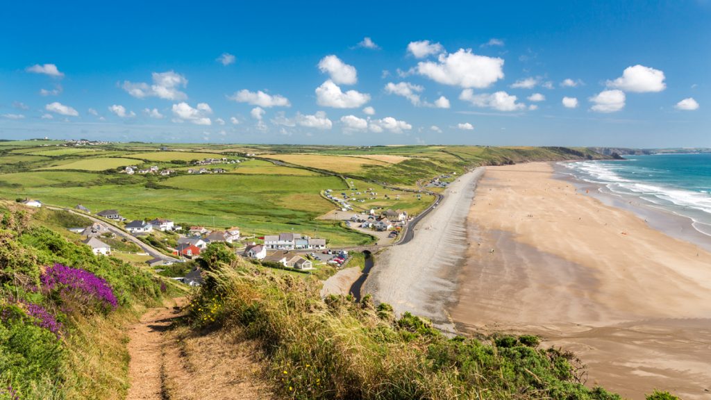
Broad Haven Beach (Grid ref: SM859138)
Large gently shelving sandy beach with rock pools at each end. There is occasionally an area of quicksand on this beach.
Facilities
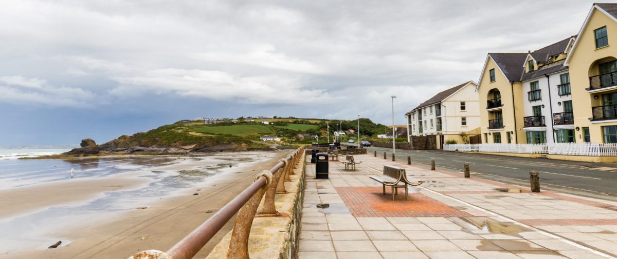
Broad Haven Town (Grid ref: SM861137)
Small seaside town with all the usual services.
Information
Broad Haven (Grid ref: SM861137)
The beach at Broad Haven has been popular since 1800, when there were bathing machines on the sands. The artists Gwen and Augustus John spent childhood holidays at Rocks Drift, a house built by their father, now converted into holiday apartments. Coal was mined on the cliffs north of the beach, where collapsed pits are visible beside the path. The original village nestles under the lee of the hill at the south end of the beach.
Car Park / Public Transport Access
Broad Haven Bus Stop (Grid ref: SM861137)
Bus stop – Puffin Shuttle – thrice daily return – St David’s to Milford Haven.
Facilities
Galleon Inn (Grid ref: SM860136)
Food and beer.
Car Park / Public Transport Access
Broad Haven Car Park (South) (Grid ref: SM860135)
20 car car park. WC.
Caution
Settlands Beach Route (Grid ref: SM856133)
Many people use the beach, but there is a danger of being cut off – knowledge of the tides is needed. The particular danger is that although it looks like there is one headland to pass, in fact there are two and the tide reaches one before the other.
Facilities
The Castle Hotel (Grid ref: SM857129)
B&B, Beer & Food
Facilities
Little Haven (Grid ref: SM857129)
Village services, B&Bs, 3 pubs, bistro, cafe.
Information
Little Haven (Grid ref: SM857129)
This charming village, with its narrow lanes, cottages, inns and tiny bay, is a popular holiday spot. Like Nolton Haven, it was formerly an export point for local coal, which was loaded aboard sailing coasters on the beach at low tide.
Car Park / Public Transport Access
Little Haven Car Park (Grid ref: SM857128)
Medium National Park car park – charge in season. WC.
2. Little Haven to Strawberry Hill 0.8 Miles (1.61km)
The first few hundred meters are surfaced (Grade 1). Thereafter there are some steep hills. High crumbling cliffs to seaward, views northward along the beaches to Broad Haven. 0 stiles, 2 gates, 35 steps.
Walk Difficulty – Stiles or flights of steps or steep hills.
Car Park / Public Transport Access
Little Haven Bus Stop (Grid ref: SM857129)
Bus stop – Castle Hotel (Puffin Shuttle – thrice daily return – St David’s to Milford Haven). Medium National Park car park: charge in season. WC.
Beach
Little Haven Beach (Grid ref: SM856130)
Small sandy cove.
Walking Access Point
The Point Wheelchair Path (Grid ref: SM856129)
The Point Path, Little Haven SM 856129 Gradients to Fieldfare standard; cross fall is negligible. Brick type surface. Seats. WC at Little Haven car park. Wheelchair 300m.
Caution
Falling Cliff (Grid ref: SM852126)
Unguarded cliff edge. Keep to path. Take care in windy weather. Short sections of path fairly close to the cliff edge.
Information
Foxes’ Hole (Little Haven) (Grid ref: SM849123)
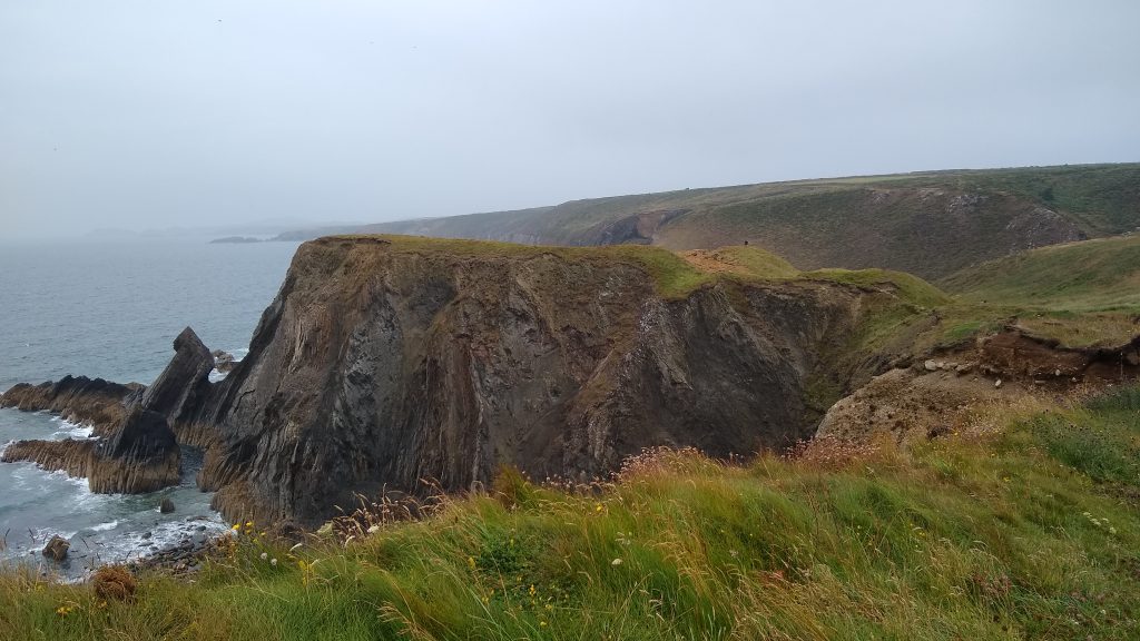
About 1 km (0.6 miles) south of Little Haven, the rock type changes. From here, the imposing cliffs are made up of Precambrian igneous rocks, about 650 million years old. Due to movements of the Earth’s crust, these ancient rocks lie alongside the Coal Measures which are only 300 million years old. At Foxes’ Hole, a narrow inlet just north of Mill Haven, the cliffs change again to the distinctive Old Red Sandstone. The difference is noticeable in the rich red-brown soil of nearby fields.
3. Strawberry Hill to St Bride’s 4.5 Miles (6.44km)
The southern section is almost flat apart from the short hills at each end. The northern section is a long steady hill but not very steep. Wide open views across St Bride’s Bay. 0 Stiles, 4 kissing gates, 3 wicket gates, 8 steps.
Walk Difficulty – No stiles or flights of steps, gradients less than 1:6.
Walking Access Point
Strawberry Hill Parking (Grid ref: SM851124)
Junction with the minor coast road. Limited roadside parking for 3 cars, seat. No WC.
Walking Access Point
Strawberry Hill Wheelchair (Grid ref: SM851124)
Strawberry Hill, Little Haven. Very short path to viewpoint from small roadside car park on the road towards Dale. Views of Goultrop Roads and St Bride’s Bay. Seat. WC at Little Haven car park. Wheelchair 20m.
Walking Access Point
Goultrop (East) Footpath (Grid ref: SM846123)
A short footpath link to the minor coast road, no parking space
Caution
Goultrop (West) Footpath (Grid ref: SM840124)
Danger!! A footpath is shown on the maps that leaves from the seaward side of the Coast Path to the site of an old lifeboat station. As a result of a series of landslides affecting the seaward end of this path, it now terminates at a sheer unstable cliff, therefore its use is not recommended.
Walking Access Point
Mill Haven Footpath (Grid ref: SM856123)
This footpath offers an inland return to Little Haven along very minor country roads. It also offers an inland return for a circular walk based on St Bride’s Haven. Limited roadside parking at Talbenny Cross.
Beach
Mill Haven Beach (Grid ref: SM816123)
A small rocky remote beach.
Worth a look
Mill Haven Sculptures (Grid ref: SM816123)
An ancient lime kiln and the surviving wall of an old boat house are complimented by ‘the womb of the sea’ – a modern (early 1990s) sculpture commissioned by the Arts Council and the landowner. Carved stones on the three approaches to the cove are part of the same display.
Caution
St Bride’s to Mill Haven Cliffs (Grid ref: SM809122)
Unguarded cliff edge. Eroding cliff edges. Keep to path. Take care in windy weather. Quite long sections of path fairly close to the cliff edge.
Worth a look
St Bride’s to Mill Haven (Grid ref: SM809122)
Spectacular drifts of Thrift (Sea Pinks) and other flowers in season.
4. St Bride’s Haven to Tower Point 1 Miles (1.61km)
Two short hills (1:10) and 250 metres of rolled stone surface just west of St Bride’s. A long almost imperceptible hill between St Bride’s and Tower Point. 2 accessible gates, 0 stiles, 0 steps.
Walk Difficulty – No man made obstructions to wheelchairs, ground conditions vary.
Car Park / Public Transport Access
St Bride’s Bus Stop (Grid ref: SM805108)
The bus stop is 250 metres inland of the car park at the road junction. (Puffin Shuttle – thrice daily return – St David’s to Milford Haven)
Car Park / Public Transport Access
St Brides Haven Parking (Grid ref: SM80291089)
Limited, free informal parking, WC.
Worth a look
St Bride’s Pump House (Grid ref: SM80321088)
Old Pump House restored by The Friends of the National Park and full of useful interpretation about the area. The pump that is still in place once supplied St Bride’s Castle with water.
Information
St Brides (Grid ref: SM80261084)
St Bride was probably St Brigid of Kildare, who lived in the late 5th to early 6th centuries. The present medieval church is thought to have replaced an older chapel. The large house overlooking the bay, known as St Brides Castle, was once the home of the Edwardes family, Barons of Kensington, but now contains holiday apartments. Some of the former estate, including the cove itself, is now owned by the National Park Authority.
Walking Access Point
St Bride’s Church Path (Grid ref: SM80251088)
A footpath starting beside the church offers a field-edge inland route to Marloes village.
Beach
St Brides Haven (Grid ref: SM80191092)
A small sandy cove with rock pools, popular with scuba divers when the visibility under-water is good.
Walking Access Point
St Bride’s Wheelchair Path (Grid ref: SM80221089)
Short rolled stone path from the car park to a viewpoint, slight downhill at 1:20. Views of St Bride’s Haven. Seat. Accessible WCs at Dale and Little Haven. Wheelchair 15m.
Walking Access Point
St Brides to Tower Point Easy Access (Grid ref: SM80221089)
The rolled stone section and footbridge have been damaged by the 2014 storms and may not be reinstated; awaiting reassessment. After a short rolled stone path to the picnic site there is a steep slope down at 1:10 for 20m then 1:8 for 20m, no landings. Then another 230m of surfaced path through a field and to a viewpoint on the cliff path with a 1:10 slope for 40m. From then on the path is rough and unimproved, muddy when wet, with a steady rising gradient around 1:20. One seat near the start, one seat at halfway. 2 gates that may need assistance for users of long wheelchairs. Accessible WCs at Dale and Little Haven. Easy Access Path 1.8 km.
Caution
St Brides Haven Cliffs (Grid ref: SM79861107)
Unguarded Cliff Edges. Keep to path. Short sections of path fairly close to the cliff edge.
Worth a look
The Nab Head Iron Age Sites (Grid ref: SM79081105)
This headland was occupied by hunting-and-gathering people in the Mesolithic period, about 9,000 years ago, probably as a seasonal camp. Excavations in 1979 recovered nearly 40,000 items, including a large number of beads, which may have been the site’s speciality. Further along, on Tower Point, there is a fine Iron Age promontory fort. Castle Head Iron Age promontory fort lies half way between The Nab Head and St Bride’s.
5. Tower Point to Musselwick Sands 2.84 Miles (4.83km)
Again an undemanding section. The only steep hill being at Musselwick, can be avoided by taking the inland and higher path. 0 stiles, 5 gates, 0 steps. Coastal slopes rich in wild flowers. In places the red of the Old Red Sandstone is brightly streaked with yellow algae.
Walk Difficulty – Stiles or flights of steps or steep hills.
Caution
Old Red Sandstone Cliffs (Grid ref: SM78820917)
Unguarded cliff edges. Keep to path. Short sections of path fairly close to the cliff edge.
Beach
Musselwick Sands Beach (Grid ref: SM78420888)
Good sized very tidal, sandy beach, sheltered from south west winds.
Caution
Musselwick Sands (Grid ref: SM78420888)
Musselwick Sands are good for a swim, but it’s easy to get cut off here. The tide comes in at the access point long before it covers the rest of the sand. The informal escape routes are dangerous and not advised.
Walking Access Point
Marloes Village Footpath (Grid ref: SM78720885)
This footpath offers the shortest route to the shop and pubs in Marloes, and also the opportunity for shorter or longer circuits of the Marloes peninsula.
6. Musselwick to Martin’s Haven 2 Miles (3.22km)
Quite a rugged feel – not a very strenuous section, but four short steep hills push the grade up to five. The last or first views across St Bride’s Bay, right across to St David’s and Ramsey. 0 stiles, 5 gates, 60 steps.
Walk Difficulty – Stiles, long flights of steps, gradients up to 1:1.
Car Park / Public Transport Access
Musselwick Sands Parking (Grid ref: SM78660854)
Hail and Ride – Puffin Shuttle – thrice daily return – St David’s to Milford Haven. Limited roadside parking for about 10 cars. WC in the village.
Facilities
Trailside Campsite (Grid ref: SM7640911)
West Hook Farm
Caution
Musselwick to Martin’s Haven Cliffs (Grid ref: SM76140920)
Unguarded cliff edge. Keep to path. Short sections of path fairly close to the cliff edge.
Information
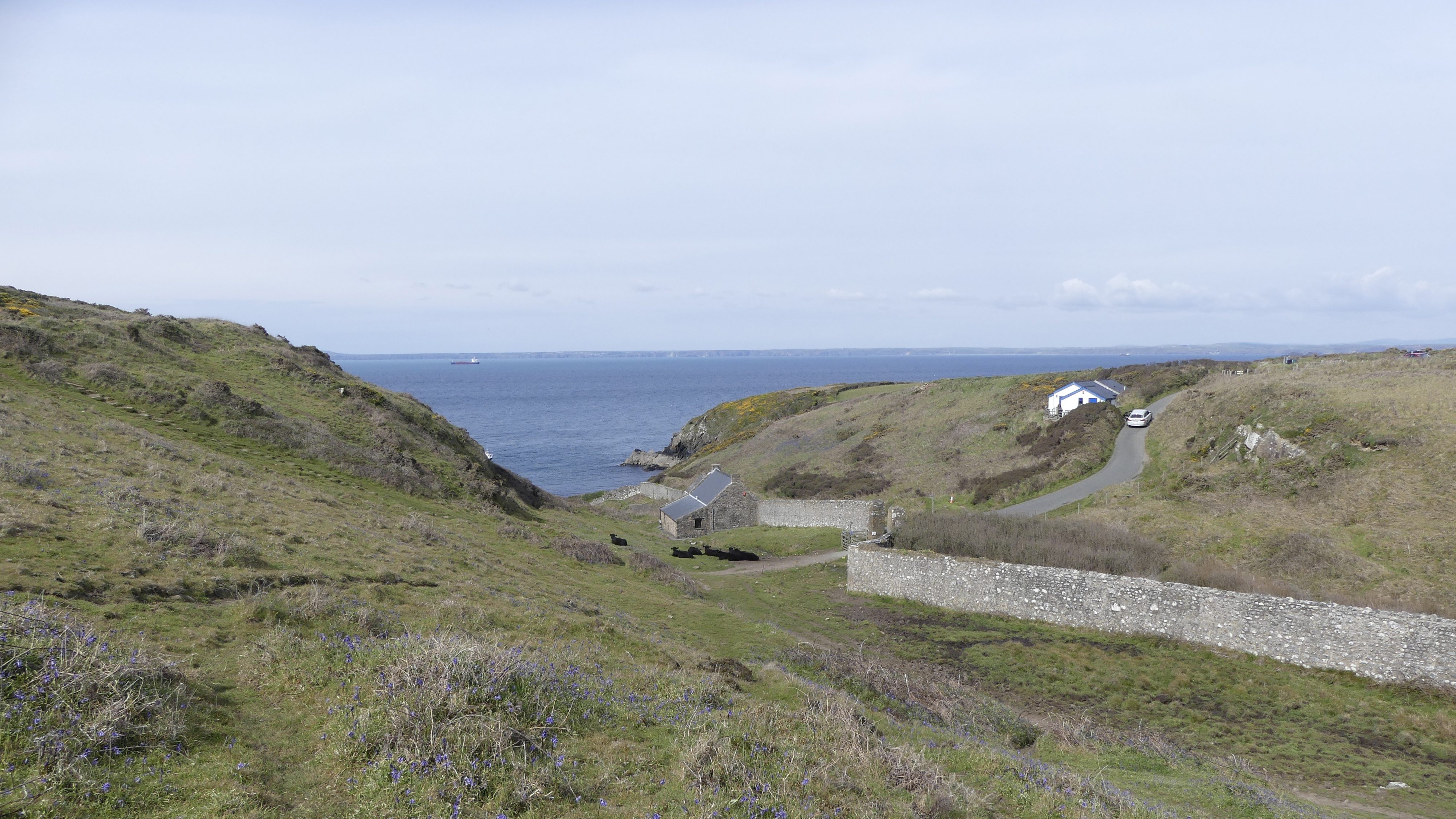
Martin’s Haven (Grid ref: SM76060916)
This sheltered bay is the embarkation point for Skomer and Skokholm islands, both internationally famous for their wildlife. They’re managed by the Wildlife Trust West Wales, which has an information centre perched on the hillside overlooking the bay. Martin’s Haven is also popular with divers. The sea-bed in this area is one of only three designated marine nature reserves in Britain. There’s an exhibition about it in the converted cottage near the beach provided by the Countryside Council for Wales who manage the reserve.
Beach
Martin’s Haven Beach (Grid ref: SM76060916)
Small stony beach. Not good for swimming because of the boats.
Facilities
Martin’s Haven WC (Grid ref: SM76030901)
Not at the car park – on the track to the beach. Park in the car park and walk to the toilet- turning on the roadside is difficult and in summer is crowded.
VIEW THIS SECTION ON STREET VIEW
Broad Haven (Grid ref: SM860135)
Follow the Coast Path Safety Code
- Take care on the Coast Path - it's rugged, natural terrain.
- Keep to the path, away from cliff edges and overhangs.
- Always supervise children, especially near cliff edges.
- Walking surfaces can vary considerably with the weather. Always wear strong footwear with a good grip and ankle support.
- Wear or carry warm and waterproof clothing.
- Cliff-top walking can be dangerous in high winds.
- Beware of taking shortcuts across beaches - you may be cut off by the tide. Swimming can also be dangerous.
- Do not sit under cliffs or climb them.
- Keep dogs under close control.
- The Coast Path is for walkers. It is not safe or lawful to ride horses or cycle along most of the Coast Path.
- Leave gates and property as you find them.
- Note that mobile phone coverage is unreliable on the coast.